|
|
|
|
||||||||||||||||||||||||||||||
|---|---|---|---|---|---|---|---|---|---|---|---|---|---|---|---|---|---|---|---|---|---|---|---|---|---|---|---|---|---|---|
|
1999 PRELIMINARY
REPORTS |
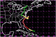
Dennis was a larger-than-average western Atlantic hurricane that was erratic in both track and intensity. Although it never made landfall as a hurricane, it affected the North Carolina coast with hurricane force winds, heavy rains, prolonged high surf, and beach erosion. Dennis also produced tropical storm force winds over portions of the Bahamas. a. Synoptic HistoryThe origin of Dennis can be traced to a tropical wave that moved off the coast of Africa on 17 August. The system moved westward with little significant weather until 21 August, when associated shower activity increased a few hundred miles northeast of the Leeward Islands. A low- level circulation developed over the next two days as convective organization increased. An investigative flight by the Air Force Reserve Hurricane Hunters failed to find a surface circulation on the 23rd. However, the aircraft data indicated a circulation was present at 850 mb. Later surface observations showed a closed circulation, and it is estimated that Tropical Depression Five formed at 0000 UTC 24 August about 190 nautical miles east of Turks Island. Reconnaissance data and ship reports indicated further intensification, and the depression became Tropical Storm Dennis at 1200 UTC the same day. The initial structure was unusual. Dennis was at the east-southeast end of an elongated trough that extended to southern Florida. This and upper-level westerly shear caused an asymmetric pattern of convection and tropical storm force winds, with both confined to the eastern semicircle on 24-25 August. Despite the shear, the cyclone intensified unsteadily and reached hurricane strength early on the 26th. The unusual structure may have also affected the cyclone's motion. Dennis initially moved at 10 to 14 mph, but slowed to an erratic 3 mph on 25 August as steering currents weakened due to a mid-latitude trough passing to the north. At one time that day, the center appeared to re-form eastward along the trough axis. Once Dennis reached hurricane strength, it began a more steady northwestward motion near or over the eastern Bahamas. This motion continued into the 28th. Westerly shear persisted, preventing significant strengthening until late on 27 August. After the shear decreased, Dennis reached a peak intensity of 104 mph on the 28th and maintained that intensity until early on the 30th. Even at peak intensity, Dennis never consolidated into a classic tightly-wound hurricane. The eye was 30 to 40 miles wide, and on several center fixes the Hurricane Hunters did not report an eye. The radius of maximum winds was as large as 70 to 85 nm on the 29th and 30th. A second mid-latitude trough caused Dennis to turn gradually northward on 28-29 August, which was followed by acceleration to the east-northeast on 30th and 31th. This turn kept the center about 60 miles south of the North Carolina coast. The east-northeast motion continued until the trough passed Dennis on the 31st. At that time, steering current collapsed and the cyclone slowed to an erratic drift about 110 nautical miles east of Cape Hatteras, North Carolina. The erratic motion would last into 2 September. During this time, Dennis became involved with the cold front associated with the mid-latitude trough. A combination of vertical shear and cool dry air entraining into the circulation decreased the convection and weakened the cyclone. Dennis weakened to a tropical storm on 1 September, and on the 1st and 2nd may have been as much a subtropical or extratropical cyclone as a tropical cyclone. Despite the lack of convection, surface observations indicate maximum sustained winds were near 52 mph during 2 September. Some of these winds were due to the combination of Dennis and a strong surface ridge north of the front, which caused 39 mph or greater winds as far north as the New Jersey coast. A large westerly ridge over the eastern United States forced
Dennis southward late on 2 September. This motion toward warmer water
probably aided a deep convective burst on the next day. Later that day,
Dennis turned northwest toward the North Carolina coast as the ridge moved
east into the Atlantic. This motion continued on the 4th along with re-intensification.
Dennis was just below hurricane strength when it made landfall over the
Cape Lookout National Seashore just east of Harkers Island, North Carolina
at 2100 UTC that day. Dennis continued inland and weakened to a depression
on the 5th over central North Carolina. Even in dissipation, Dennis continued
to move erratically. Figure 1 shows that the cyclone followed a zig-zag
course northward for the rest of its life. Dennis became extratropical
on the 7th and was absorbed into a larger low on the 9th.
b. Meteorological Statistics
| |||||||||||||||||||||||||||||
| Date/Time (UTC) |
Position | Pressure (mb) |
Wind Speed (mph) |
Stage | |
|---|---|---|---|---|---|
| Lat. (°N) | Lon. (°W) | ||||
| 30/0600 | 32.8 | 77.6 | 962 | 105 | Category 2 Hurricane |
Landfall
for Hurricane Dennis
24 August - 08 September, 1999
| Date/Time (UTC) |
Pressure (mb) |
Wind Speed (mph) |
Stage | Landfall |
|---|---|---|---|---|
| 28/0700 | 976 | 85 | Category 1 Hurricane | Abaco Islands, Bahamas |
| 04/2100 | 984 | 70 | Tropical Storm | Cape Lookout, North Carolina |