|
|
|
|
|||||||||||||||||||||||||||||||||||||||||||||
|---|---|---|---|---|---|---|---|---|---|---|---|---|---|---|---|---|---|---|---|---|---|---|---|---|---|---|---|---|---|---|---|---|---|---|---|---|---|---|---|---|---|---|---|---|---|
|
1999 PRELIMINARY
REPORTS |
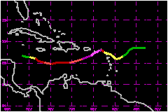
Hurricane Lenny was the fifth category-four hurricane on the Saffir/Simpson Hurricane Scale (SSHS) of the 1999 season - a record. This hurricane had a major impact on numerous land areas in the Caribbean Sea. Moreover, Lenny was the first storm to have an extended west-to-east track across the central and eastern Caribbean Sea in the 113-year Atlantic tropical cyclone record. a. Synoptic HistoryA broad area of low pressure was first identified in the southwest Caribbean Sea early on 8 November. Later that day, there was sufficient convective banding to warrant a T1.0 Dvorak satellite-based intensity classification from the Tropical Analysis and Forecast Branch (TAFB) at TPC. Although thunderstorm activity associated with the low remained poorly organized, locally heavy rains and strong gusty winds occurred over the northwest Caribbean Sea and adjacent portions of Central America and Mexico for several days. On 12 November, a U.S. Air Force Reserve (USAFR) Hurricane Hunter aircraft investigated the disturbance but failed to find a well-defined surface circulation center. Early on the 13th, satellite imagery showed that the system was gradually becoming better organized. Later that afternoon the Hurricane Hunters found 35 mph surface winds and a 1003 mb central pressure. Tropical Depression Sixteen formed about 150 nautical miles south of the Cayman Islands at 1800 UTC 13 November. By mid morning of the 14th, the overall organization of the depression was improving and the depression was estimated to have become Tropical Storm Lenny at 1200 UTC 14 November. A USAFR reconnaissance mission the afternoon of the 14th found maximum flight-level (1500 ft) winds of 97 mph and a central pressure of 988 mb. Lenny became a hurricane at 0000 UTC 15 September while centered about 150 miles southwest of Kingston, Jamaica. DMSP SSM/I imagery near this time showed a banding-type eye 15-20 nautical miles in diameter. During the next 12 hours, the central pressure fell 10 mb and Lenny strengthened to a 98-mph, category two hurricane on the SSHS. By the evening of the 15th, the eye was no longer discernible in satellite imagery, the overall cloud pattern became less organized, and Lenny weakened to 86 mph. One of the most interesting aspects of Lenny was its extended west-to-east motion through the Caribbean, unprecedented in the 113-year Atlantic basin tropical cyclone record. For its first 48 hours, Lenny moved on a east to east-southeast course. This motion was induced by the flow around the southern portion of a deep-layer trough located over the western Atlantic. Several shortwave troughs helped to amplify the mean western Atlantic trough through the period which increased the westerly steering flow. From 1200 UTC 15 November to 1800 UTC 16 November, Lenny's mean forward motion was 16 mph. The weakening on the 15th was temporary and Lenny re-intensified early on the 16th. During a 24 hour period beginning about midday on the 16th, the central pressure dropped 34 mb. Lenny's maximum sustained surface winds of 155 mph and minimum central pressure (933 mb) occurred at 1800 UTC 17 November when the hurricane was centered about 18 nautical miles south of St. Croix in the U.S. Virgin Islands. However, the 155-mph winds were confined to the southeast quadrant of the hurricane and these strongest wind speeds did not occur over land. Lenny moved into a col point between two mid-level ridges late on the 17th and its forward motion slowed. The hurricane drifted east-northeastward before turning southeastward early on the 19th. Despite what appeared in satellite imagery as a favorable upper-level outflow pattern, Lenny weakened, perhaps due to upwelling. Lenny was gradually weakening when its center passed very slowly over St. Maarten during the afternoon of the 18th, Anguilla later that evening, and St. Barthelemy early on the 19th. Lenny weakened to a tropical storm on the 19th just south of St. Barthelemy. The storm made its final landfall in Antigua late on the 19th. Lenny continued to move southeastward and the forward motion
increased to near 9 mph. The motion turned again toward the northeast
as Lenny weakened to a depression at 0000 UTC 21 November. The depression
turned back to the east early on the 21st and Lenny dissipated on the
morning of the 23rd about 600 nautical miles east of the leeward islands.
b. Meteorological StatisticsThe majority of the aerial reconnaissance flights into Lenny were done by the USAFR "Hurricane Hunters". The Hurricane Hunters flew 17 reconnaissance missions, and made 46 center fixes while NOAA aircraft performed two missions contributing four center fixes. Lenny also featured the first utilization of the new USAFR WC130-J model aircraft for reconnaissance. Figure 5 is a radar image from the new J model at 0321 UTC 18 November right before it penetrated the eye for a fix. The peak intensity of Lenny, 155 mph, is based on 90% of the 171 mph flight-level (700 mb) wind speed reported at 1702 UTC 17 November. The GPS dropsonde from this fix operationally measured 207 mph at 891 mb. Post-flight processing corrected this value to 210 mph, a record dropsonde wind speed in a hurricane. The lowest pressure recorded by the aircraft was 934 mb at 1929 UTC 17 November. However, the minimum central pressure of 933 mb was assigned based on the lower 700 mb height on the 1702 UTC fix. The 929 mb pressure from the 2134 UTC fix was an extrapolated value and has been discounted. The highest official sustained surface wind speed (gust) observed over land was 84 mph (104 mph) at the St. Maarten Meteorological Office in Phillpsburg at 0200 UTC 19 November. However, the meteorological antenna fell down during the strongest winds. Hamilton Airport on St. Croix recorded sustained 1-minute winds of 69 mph, with a gust to 92 mph, at 1933 UTC 17 November. The lowest official pressure observed in the northern Leeward Islands was 972.1 mb at the St. Maarten Meteorological Office at 0200 UTC 19 November. The maximum sustained surface wind speed reported via amateur
radio operators was 93 mph on St. John in the U.S. Virgin Islands at 1900
UTC 17 November. During the peak of the hurricane, Saba recorded a gust
of 167 mph (2600 ft elevation) before the anemometer blew away. The highest
measured gust on St. Croix was 112 mph at 2000 UTC 17 November, two hours
after Lenny reached its peak intensity. This gust measurement coincides
with Lenny's closest approach to the island. The minimum central pressure
at St. Croix, 980 mb, was also recorded at this time.
1. Storm Surge DataFredericksted in St. Croix was inundated by an estimated 15 to 20 ft storm surge. However, a complete storm surge survey has not been completed at this time. The maximum recorded storm tide was 2.9 feet at the NOAA National Ocean Service (NOS) gage in Lime Tree Bay on St. Croix. NOAA NOS gages recorded 1.8 feet on St. Thomas and in Puerto Rico (San Juan). There was also considerable coastal erosion reported on St. Croix. Lenny's approach from the west produced unprecedented wave and storm surge impact on westward-facing coasts and harbors. The meteorological service in Dutch St. Maarten reported that southern and western coastal areas were significantly impacted by wave action. The Metro-France meteorological station in Gustavia on St. Barthelemy estimated waves of up to 16 feet in the harbor on 17 November. A platform near La Desirade, just east of Grande-Terre Guadeloupe, recorded a significant wave height of 9.8 ft at 2300 UTC 20 November. Estimates range up to 13 ft in the harbor. Lenny generated large waves and swells that propagated across
much of the southern and eastern Caribbean, affecting the Guajira Peninsula
of Colombia, Aruba, Bonaire, Curacao, and much of the remainder of the
Leeward and Windward Islands.
2. Rainfall DataLenny's slow drift across the northern Leeward Islands for a 36-hour period resulted in some very high rainfall amounts. For many locations heavy rains over several days was the primary impact of Lenny. Portions of French St. Martin, St. Barthelemy, and Guadeloupe received record rains. The highest reported storm-total rainfall was 34.12 inches on St. Martin at Gendarmerie. This included a 24-hour record of 18.98 inches on the 18 November. St. Martin Marigot D.D.E. recorded 26.10 inches. Of this total, a record 22.64 inches fell in a 24-hour period beginning around midday on the 17th. Rainfall totals on St. Barthelemy were about 15 inches while 6 to 12 inch totals were typical on Guadeloupe. The highest rainfall total in Dutch St. Maarten was 27.56 inches recorded at the meteorological office in Phillpsburg resulting in mud slides in the area. V.C. Bird International Airport in Antigua reported 18.32 inches in association with Lenny. A little over 25 inches was recorded in the southern portion of the island. There were reports of mud slides from St. Kitts. Rainfall totals averaged 3 to 4 inches across the U.S. and
British Virgin Islands. Hamilton Airport in St. Croix measured 8.05 inches
of rain, resulting in widespread flooding around the island inundating
many homes. The highest official rainfall total in Puerto Rico was 9.39
inches on Magueyes Island, Lajas. Co-op observer rainfall totals across
Puerto Rico averaged 4 to 8 inches with the highest value, 12.39 inches,
reported in Toro Negro Orocovis. Landslides and mud slides were reported
in interior and west sections of Puerto Rico.
| ||||||||||||||||||||||||||||||||||||||||||||
| Date/Time (UTC) |
Position | Pressure (mb) |
Wind Speed (mph) |
Stage | |
|---|---|---|---|---|---|
| Lat. (°N) | Lon. (°W) | ||||
| 17/1800 | 17.4 | 64.8 | 933 | 155 | Category 4 Hurricane |
Landfall
for Hurricane Lenny
13 - 23 November, 1999
| Date/Time (UTC) |
Pressure (mb) |
Wind Speed (mph) |
Stage | Landfall |
|---|---|---|---|---|
| 17/1800 | 933 | 155 | Category 4 Hurricane | St Croix, U.S Virgin Islands |
| 18/1800 | 966 | 125 | Category 3 Hurricane | St. Martin |
| 19/0000 | 975 | 100 | Category 2 Hurricane | Anguilla |
| 19/0600 | 979 | 85 | Category 1 Hurricane | St. Barthelemy |
| 20/0000 | 994 | 65 | Tropical Storm | Antigua |