|
|
|
|
|||||||||||||||||||||||||
|---|---|---|---|---|---|---|---|---|---|---|---|---|---|---|---|---|---|---|---|---|---|---|---|---|---|
|
1999 PRELIMINARY
REPORTS |
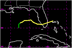
Tropical Storm Harvey, which formed in the eastern Gulf of Mexico and moved across southern Florida, produced heavy rainfall over portions of southwest Florida. a. Synoptic HistoryThe tropical wave that produced Harvey moved off the west coast of Africa late on 4 September with little fanfare. From the 4th through the 14th, the wave's trek across the tropical Atlantic into the eastern Caribbean Sea was uneventful. This was due, in part, to the disruptive effects of the upper-level outflow from Hurricane Floyd. By 16 September, with the influence of Floyd's circulation abating, convective activity in association with the wave began to increase over the western Caribbean Sea and a broad area of low pressure formed. Upper-air observations from the northwest Caribbean showed an associated mid-level circulation near the Cayman Islands. The system drifted northwestward during the next two days and by the morning of the 18th, the broad area of low pressure was over the south central Gulf of Mexico. Early on the 19th, satellite imagery showed increasing deep convection near and east of the broad surface circulation center. This, coupled with a sustained 35 mph wind report from the National Data Buoy Center (NDBC) buoy 42003, located in the eastern Gulf of Mexico, is the basis for initiating Tropical Depression Ten at 0600 UTC 19 September, at which time the circulation center was located about 350 nautical miles west-southwest of St. Petersburg, Florida as shown in the post-storm "best track". Upper-tropospheric outflow improved over the depression throughout the 19th, indicative of gradual strengthening . Surface observations and reconnaissance data from the U.S. Air Force Reserve "Hurricane Hunters" (USAFR) indicated that by 0000 UTC 20 September surface winds were near 46 mph and the system became Tropical Storm Harvey, while located about 300 nautical miles west-southwest of St. Petersburg, Florida. Over the next 24 hours, Harvey's central pressure dropped a modest 7 mb and the storm is estimated to have reached a peak intensity of 58 mph from 1800 UTC 20 September to 1800 UTC 21 September. Satellite images showed that the system did not become better organized during this period because of westerly vertical wind shear. Data from the NOAA G-IV synoptic flow mission over the Gulf of Mexico on the afternoon of the 20th showed 29 to 40 mph westerly upper-level winds over the cyclone. This resulted in the displacement of Harvey's center to the northwest edge of the deep convection along with restricted outflow over the western semicircle. Satellite imagery also suggested that dry air was being entrained into the circulation from the northwest. After turning from a north to a northeast heading on the
afternoon of the 19th, Harvey moved slowly eastward on the 20th. By early
on the 21st, the system turned southeast and the forward speed increased
to 10 mph in response to mid-level northwesterly flow depicted in NOAA
G-IV synoptic flow data. Harvey's track bent back to the east by mid morning
of the 21st and the cyclone accelerated in advance of a mid-latitude trough
approaching from the west. Harvey made landfall near Everglades City,
Florida around 1700 UTC 21 September with maximum sustained winds of 58
mph and a minimum central pressure of 999 mb. Later that afternoon, the
center of Harvey became elongated while becoming absorbed by a developing
extratropical cyclone located just off the coast of South Carolina with
an associated front extending into south Florida. Harvey lost its identity
over the western Atlantic early on the 22nd as it merged with the extratropical
cyclone. b. Meteorological StatisticsThe USAFR Hurricane Hunters flew five reconnaissance missions into Harvey and made 14 center fixes. The highest wind speed reported in Harvey was 67 mph, at 1500 feet, at 1554 UTC 21 September; the lowest central pressure was 994 mb at 0813 UTC 21 September.The maximum sustained wind of 58 mph at 1800 UTC 20 September was based on an observation of 54 mph from ship WCOB; The C-MAN buoy at Molasses Reef (MLRF1) recorded a maximum wind of 54 mph, with a gust to 68 mph, at 1743 UTC 21 September while Fowey Rocks Light (FWYF1) reported 52 mph sustained winds, with a gust to 59 mph at 1800 UTC, and the aircraft data, all support the continuation of the 58-mph maximum sustained wind speed in the best track through 1800 UTC 21 September. The highest official sustained surface wind observed over land was 37 mph at the Key West Airport at 1956 UTC 21 September. The Turkey Point Nuclear Power Plant recorded a 10-minute 53 mph wind, at a 9 meter elevation, at 1610 UTC 21 September while the highest gust, 55 mph, was recorded at Tenraw in the Everglades in Dade County (25.6N/81.9W) at 1700 UTC. The lowest pressure observed in south Florida was 999.4 mb at the Fort Lauderdale Airport at 1953 UTC 21 September. A Carnival Cruise Line vessel provided two
observations on 20 September of tropical storm-force winds. These reports
were used to help define the tropical storm-force wind and the 12-foot
sea radii. 1. Rainfall DataThe highest storm-total rainfall recorded in Harvey was 10.03
inches at the Naples Conservancy in Collier County. Naples Lakewood measured
10 inches of rainfall while Naples/Collier County Emergency Management
estimated a similar amount at their operations center. These
measurements are consistent with NWS doppler radar estimates. Substantial
street flooding was reported in the Naples area. Street flooding was also
reported in portions of Lee County, with two homes flooded in Bonita Springs.
Rainfall totals of 5.53 and 6.72 inches were observed at Immokalee and
Everglades City, respectively. Storm total rainfall across Miami-Dade,
Broward, and Palm Beach counties ranged from 0.75 inches (West Palm Beach
Airport) to 2.85 inches (Coral Springs). 2. Storm Surge DataThe maximum recorded storm surge was 2.41 feet at Fort Myers
with estimates of 2 to 3 feet common elsewhere in Charlotte County. Storm
surge values ranged from 1 to 2 feet elsewhere in southwest Florida and
in the Florida Keys. Tidal flooding was reported in Everglades City including
the county airport where a portion of the runway was flooded resulting
in the closure of the airport. Minor coastal flooding was also reported
along the south-facing portions of the Florida Keys and the west-facing
shores of Florida Bay. Sections of Highway A1A in the Keys were closed
due to the flooding. The combined effect of wave action and the storm
surge resulted in minor beach erosion in Sarasota County, along the south-facing
shores of the Keys, and in the back country of Everglades National Park. 3. TornadoesHarvey resulted in two confirmed tornadoes. One tornado,
an F0, touched down briefly in Collier County near Paradise Point taking
the roof off one house, while the other touched down in Dade County with
no reported damage. c. Casualty and Damage StatisticsNo reports of casualties due to Harvey have been received at the National Hurricane Center. Property damage estimates supplied by the Property Claims Services Division of the American Insurance Services Group indicate that Harvey caused about $7.5 Million in insured losses in southern Florida. This estimate excludes storm surge damage. To determine the total estimated damage, a ratio of 2:1 is applied to the insured property damage; this is based on comparisons done in historical hurricanes. Thus, the total estimated damage from Harvey is $15 Million.
Maximum Intensity For Tropical Storm Harvey
Landfall
for Tropical Storm Harvey
| ||||||||||||||||||||||||