|
|
|
|
|||||||||||||||
|---|---|---|---|---|---|---|---|---|---|---|---|---|---|---|---|
|
1999 PRELIMINARY
REPORTS |
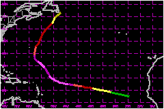
a. Synoptic HistoryGert originated from a tropical wave. When it moved from west Africa to the Atlantic on 10 September, there was already convective banding and some evidence of a low-level cloud circulation. The developing tropical cyclone's path was toward the west-northwest from the 10th to the 16th as it moved to the south of the subtropical high pressure ridge. The best track starts on the 11th, south of the Cape Verde Islands. This is when the system is estimated, using satellite imagery, to have reached tropical depression status. Gert reached tropical storm strength on the 12th and became a hurricane on the 13th. It continued to strengthen to 150 mph by the 16th. There was a weakness in the ridge downstream ahead of Gert,
an area over which intense Hurricane
Floyd had just moved. While intensifying, Gert's movement
responded to the weakness and slowly turned north and then north-northeastward
during 16th through 21st. Its center remained about 300 nautical miles
to the northeast of the Leeward Islands of the Caribbean during this turn.
With some fluctuations in intensity, winds remained near 132 mph through
the 19th, after which weakening commenced. Gert weakened to 69 mph by
the 23rd, having moved to near southeastern Newfoundland. It then became
extratropical and merged with another extratropical low pressure system. b. Meteorological StatisticsThe best track pressure and wind speed time series curves are shown in Figs. 2 and 3, along with plots of the data on which the curves are based. U.S. Air Force Reserve Unit Hurricane Hunter aircraft monitored Gert on the 16th and 17th, while there was a potential threat to the Leeward Islands, and again on the 20th and 21st, while it threatened Bermuda. Subjective Dvorak satellite wind speed estimates puts the time of Gert's peak intensity of 150 mph near 0000 UTC on the 16th. About 24 hours of reconnaissance data starting about 0800 UTC on the 16th indicates that the wind speed weakened to 138 mph and then reached 144 mph based on a GPS dropsonde measurement early on the 17th. The center of Gert passed about 115 nautical miles east of Bermuda on the 21st. The maximum 10-minute wind speed reported from airport at Bermuda was 45 mph with a peak gust to 74 mph. A gust to 87 mph was reported from an exposed coastal location. There were three instances of one-min mean winds speeds between 76 and 81 mph from a harbour location during the period 1032 - 1135 UTC on the 21st. The rainfall total for Gert was 0.53 inches. Gale conditions were also experienced on the Avalon Peninsula
on southeast Newfoundland as Gert passed close by. c. Casualties and damagesThere were 2 deaths attributed to Gert; 2 in Maine. There were news reports of 27-foot high waves sweeping over the coast near the southeast tip of Newfoundland. Three persons were swept into the water while trying to secure their boast. All were rescued. Two persons drowned on 20 September, when a large and unexpected wave swept them out to sea. They had been standing at the water's edge at Schoodic Point in Acadia National Park, Maine. The local Marine Patrol described the wave as a "rogue wave". This event is believed to be related to large swells generated by Gert, even though the hurricane was located more than 1000 nautical miles south-southeast of Maine at the time.
Maximum
Intensity For Hurricane Gert
| ||||||||||||||