|
|
|
|
||||||||||||||||||||||||||||||||||||||||
|---|---|---|---|---|---|---|---|---|---|---|---|---|---|---|---|---|---|---|---|---|---|---|---|---|---|---|---|---|---|---|---|---|---|---|---|---|---|---|---|---|
|
1999 PRELIMINARY
REPORTS |
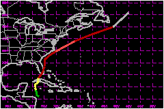
Irene was a typical wet October tropical cyclone that moved over the Florida Keys and southeast Florida dumping from 10 to 20 inches of rain. This resulted in severe flooding conditions. This type of tropical cyclone was a common phenomena during the 30's and 40's. a. Synoptic HistoryA broad area of low pressure prevailed over the southwestern Caribbean from the 8th to the 10th of October, accompanied by disorganized clouds and thunderstorms. This system did not show signs of tropical cyclone development until a tropical wave reached the western Caribbean Sea on 11 October. On the 12th, a U.S. Air Force Reserve reconnaissance plane was dispatched to the region and found an incipient low-level circulation and a broad low pressure area of 1006 mb just to the northeast of the coast of Honduras. However, the circulation was too disorganized to be classified as a tropical depression. Satellite imagery during the night showed that the thunderstorm activity increased and both banding features and upper-level outflow became quite distinct. Post -analysis of surface and upper-air dataa from Grand Cayman, and satellite Dvorak T-numbers indicate that Tropical Depression Thirteen formed in the northwestern Caribbean Sea about 0600 UTC 13 October. It reached tropical storm status by 1200 UTC on the 13th. Data from a reconnaissance aircraft later in the day confirmed Irene was a strengthening tropical storm. Irene moved on a general northward track and slowed down considerably before curving to the north-northeast just to the southwest of the Isle of Youth, Cuba, where it made its first landfall at 1200 UTC 14 October. Radars from Cuba and Key West showed the center of Irene moving on a north-northeast track over western Cuba. The center of the tropical cyclone then crossed the Havana and Ciudad Havana provinces between 2100 and 2300 UTC on the 14th. Irene reached hurricane status over the Florida Straits and the calm of the center moved over Key West near 1300 UTC 15 October. Most of the hurricane force winds were confined to the east of Irene's center over the lower to middle Florida Keys. Irene made its 4th landfall near Cape Sable, Florida and then moved across southeast Florida bringing tropical storm conditions (sustained 39-73 mph winds) and torrential rains (10 to 20 inches). During the period while Irene was crossing Florida, sustained hurricane force winds appeared to be limited to squalls offshore the east coast of Florida, as reported by reconnaissance aircraft and indicated by available National Weather Service (NWS) surface observations and Doppler radar. Irene moved back over water in northern Palm Beach County near Jupiter a little after 0000 UTC on the 16th. It retained hurricane strength and moved on a general northward track paralleling the Florida east coast heading for the Carolinas. An upper-level trough, sweeping eastward across the eastern United States, forced Irene on a fast northeast track. The core of Irene missed the mainland Carolinas but produced very heavy rains inland. It then brushed North Carolina's Outer Banks before moving out to sea. During a 12-hour period beginning on the evening of the 18th, Irene went through a rapid intensification phase. The central pressure dropped from 978 to 958 mb and the winds increased from 81 to 109 mph. This may be attributable to a combination of a trough interaction and the tropical cyclone moving over very warm water. These two factors together have been known to be the cause of explosive deepening. Hurricane Opal (1995), while located in the Gulf of Mexico, was an example. Thereafter, Irene continued to accelerate and finally became
absorbed by a much larger extratropical low near Newfoundland. The system
as a whole became an intense extratropical storm over the North Atlantic. b. Meteorological StatisticsIrene was under constant surveillance by three Cuban Weather Radars located at Havana, Isle of Youth and Pinar del Rio, respectively. Radar fixes were relayed to the National Hurricane Center by the Cuban Weather Service and then combined with fixes from Key West radar. Irene was upgraded to tropical storm status based on a satellite intensity estimate from TAFB and upper-air data from Grand Cayman, which reported 44 mph at the 5,000-feet level and 36 mph near the surface when the tropical cyclone was about 150 nautical miles from that island. Operationally, Irene was upgraded to hurricane status just before landfall over the Isle of Youth. However, numerous observations from Cuba and a post-analysis of satellite imagery indicate that Irene was most likely a tropical storm while crossing Cuba. Peak winds reported from Cuba were 78 mph at Havana forecast office. In addition to National Hurricane Service (NWS) reports, observations from the South Florida Water Management District, shown in Table 2, indicate that gusts to hurricane force were experienced near Lake Okeechobee. Based on the Miami WSR-88D (Weather Surveillance Radar -1988 Doppler) signatures, these gusts were likely produced by small-scale meso-cyclone induced downbursts. Four weak tornadoes occurred in Broward and Palm Beach counties. The rapid intensification of Irene on the 18th off the North
Carolina coast was documented by by a reconnaissance plane investigating
the hurricane during that period. The report indicated a very small closed
eyewall of about 3 nautical miles in diameter and 131 mph winds at 850-mb.
A dropsonde in the eyewall measured 148 mph at the 902-mb level. The wind
field was very small and highly asymmetric. c. Casualty and Damage StatisticsThere were 8 indirect casualties associated with Irene. They were five people electrocuted (four in Broward and one in Dade counties). There were three drowning in vehicles driving into canals (one in Palm Beach and two in Broward). In addition, there were three injured by tornadoes in Broward. Irene caused considerably damage due to flooding in South Florida. In some residential areas. Flooding lasted for a week displacing several hundred people and isolating thousands more. The total losses (agricultural and property) were estimated near $600 Million mostly in Dade, Broward and Palm Beach counties. Additional losses to near $200 Million occurred in the rest of the state of Florida. An estimated 700,000 costumers lost electricity.
Maximum Intensity For Hurricane Irene
Landfall
for Hurricane Irene
| |||||||||||||||||||||||||||||||||||||||