TROPICAL STORM BERYL 1988

Tropical Storm Beryl 1994

Preliminary Report
Tropical Storm Beryl
08 - 10 August 1988


1988 PRELIMINARY REPORTS

Tropical Storm Alberto (TS)
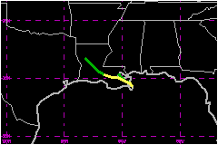
Tropical Storm Beryl (TS)
Tropical Storm Chris (TS)
Hurricane Debby (1)
Tropical Storm Ernesto (TS)
Hurricane Florence (1)
Hurricane Gilbert (5)
Hurricane Helene (4)
Tropical Storm Isaac (TS)
Hurricane Joan (4)
Tropical Storm Keith


The tropical depression which was to become Tropical Storm Beryl formed over southeastern Louisiana on the the evening of 7 August. After drifting southeastward over the Mississippi Sound during the following twenty-four hours with major portions of the system remaining over land, the depression strenghened to a storm and buffeted the immediate coastal sections and offshore oil rigs with minimal tropical storm force winds. Beryl made a clock wise loop and headed northwestward by the evening of 08 August, passing over the New Orleans area shortly before daybreak on 9 August. The short-lived tropical storm was downgraded to a depression by that evening, and the remnants became a major rain producerover northeast Texas by 11 August.


a. Synoptic History

On 1 August a weak surface low pressure center moved off the Mid-Atlantic Coast with a trailing surface through extending southwestward into the extreme northeast Gulf of Mexico. During the next several days, the northern portion of the trough dissipated. However, the portion that extended over the northeast Gulf persisted and by 3 August it began to drift slowly toward the west. Upper air analysis at 0000 UTC 3 August indicated cyclonic circulation had developed from 850 millibars upward through the 500-millibar level and a 200-millibar cut off low had formed over eastern Texas. The first sign of a surface circulation (1015-millibar) was observed at 0000 UTC 4 August on the Mississippi Coast. During the next several days, the weak broad circulation remained quasi-stationary over the Mississippi Sound. Meanwhile the middle and upper atmosphere gradually became better organized as the cyclonic circulation increased and aligned in the vertical. At the 200-millibar level the cold low drifted toward the southwest and a 200-millibar anticyclone developed over the budding storm.

By 0000 UTC 7 August the surface low had drifted toward the northwest and was centered over southeastern Louisiana. Visible satellite imagery during the day of 7 August showed a well organized system. By 0000 UTC 8 August the low center had begun to drift southeastward toward the Gulf waters, and an initial tropical depresison advisory was issued by the National Hurricane Center. Based opon ship reports and observations from oil rigs, the depression was upgraded to a tropical storm at 1000 UTC 8 August.

At this time all meteorological variables appeared favourable for development. The upper air pattern provided excellent difluence, the mid-level cyclonic circulation was well established and the surface circulation had moved back over the warm Gulf waters. However, by 0000 UTC 9 August a digging 200-millibar trough from the northeast destroyed the 200-millibar anticyclone which had recently formed over the storm. A frontal trough approaching from the northwest then caused the storm to begin moving toward the northwest, over land. As a result within the next several hours Beryl ceased to strengthen.

The lowest central pressure of 1001 millibars occured near 0600 UTC on 9 August. Note that maximum observed winds did not occur during the time of lowest pressure. Mesoscale analysis indicates the difference between Beryl's central pressure and ambient pressure decreased during the time of Beryl's minimum pressure. Perhaps the reason the strongest winds occured on the day before the lowest central pressure was observed could be attributed to the stronger pressure gradient.

By 0700 UTC Beryl began to weaken and the storm was downgraded to a depression by 2200 UTC while moving on a west northwest track over southeast Louisiana. Weakening continued on 10 August and the surface circulation dissipated on 11 August over eastern Texas.


b. Meteorological Statistics

Tropical Storm Beryl produced minimal tropical storm force winds over the open waters of the Gulf and tropical storm force Gusts over the coastal sections of southeast Louisiana, Mississippi and Alabama. A maximum sustained winds of 46 mph at Gulfport was the strongest reported from a land station, while the ship Primula DHOU and the offshore oil rig P21(MP73) each observed a maximum sustained wind of 53 mph.


1. Storm Surge Data

Higest tides, in excess of 5 feet, were observed along the east coast of extreme southeastern Louisiana. Onshore winds pushed tides to more than 4 feet above normal along the Mississippi Coast, while tides of only 1 to 2 feet above normal were observed along the coastal sections of Alabama and the extreme western Florida Panhandle.


2. Rainfall Data

Heaviest rainfall from the system occured over eastern Texas on 11 August as the remnants of Beryl dumped up to 12.5 inches of rain during the day. Storm totals of over 11 inches were reported at Dauphine Island, Alabama while close to 10 inches fell at Foley, Alabama and Bay St. Louis, Mississippi. Elsewhere, storm totals of 3 to 5 inches were received over the southern portions of Louisiana, Mississippi and Alabama


c. Casualty and Damage Statistics

There was 1 deaths attributed to Beryl; 1 in Alabama.

The only know death directly caused by the storm occured in Mobile Bay when a fifteen year old boy drowned due to an overturned shrimp boat. The boy's father was rescued by Coast Guard after spending twenty-four hours in the water.

Overall damage from the tropical storm was light. Estimates from $2 Million to $4 Million. Most of the damage occured along the immediate coast and can be attributed to erosion or flood damage due to surge and wave action.

The immediate coastal parishes of southeast Louisiana had some wind damage to trees, minor power outrages and some coastal flooding due to the storm surge. There was some voluntary evacuation in St Bernard Parish. There was no significant flooding in Louisiana due to rains. However, the heavy downpours on 11 August over portions of eastern Texas produced some flash flooding.

There was severe beach erosion along portions of the Alabama coast while considerable beach erosion occured along portions of the Mississippi coast. Dauphin Island, Alabama, had 60 to 70 feet of public beach severely damaged and man-made sand dunes washed away. Damage Estimated for the western Florida Panhandle were nil.


Maximum Intensity For Tropical Storm Beryl
08 - 10 August, 1988

Date/Time
(UTC)
Position Pressure
(mb)
Wind Speed
(mph)
Stage
Lat. (°N) Lon. (°W)
09/0600 29.6 89.5 1001 50 Tropical Storm