1988 PRELIMINARY
REPORTS
Tropical Storm Alberto (TS)
Tropical Storm Beryl (TS)
Tropical Storm Chris (TS)
Hurricane Debby (1)
Tropical Storm Ernesto (TS)
Hurricane Florence (1)
Hurricane Gilbert
(5)
Hurricane Helene (4)
Tropical Storm Isaac (TS)
Hurricane Joan (4)
Tropical Storm Keith
|
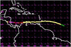
The 1988 hurricane season was unusual in a variety
of ways and Joan, the last hurricane of the season, made its contribution.
It's extremely rare that a tropical storm or hurricane hugs the north
coast of South America passing directly over Curacao in the Netherland
Antilles and over the Guajira Peninsula of Colombia. Previously in this
century only a June tropical storm in 1933 did so, although the tracks
of Edith 1971 and the depression track of Irene 1971 were only a little
to the north of that area. Usually, close proximity to land inhibits development
of tropical cyclones, but Joan reached hurricane strength just 30 nautical
miles north of the coast of Colombia. Moreover, Joan was only the second
hurricane to strike the southeast coast of Nicaragua south of Bluefields
since 1911...and by far the strongest. No other hurricane of record reached
category 4 strength south of 12°N.
a. Synoptic History
Joan formed in an ITCZ disturbance that moved off the northwest
coast of Africa south of latitude 10°N on 5 October 1988. The low-latitude
cloud cluster remained poorly organized until 9 October when satellite
pictures indicated the presence of a banding pattern with the convection
detaching from the ITCZ. By 1800 UTC, 10 October, the system had reached
tropical depression status based on satellite classifications.
Tropical Depression Seventeen continued developing and based
on satellite imagery it is estimated that it reached tropical storm status
near 0600 UTC, 11 October, with a Dvorak current intensity of 2.5. Twelve
hours later ship SNJG had 46-mph sustained wind essentially verifying
the satellite classification maximum sustained wind estimate of 52 mph
at that time.
Tropical Storm Joan continued moving westward for the next two days. Reconnaissance
aircraft reports at 1114 UTC, 13 October, verified that the system had
weakened somewhat while approaching the Windward Islands. There was little
change in the strength of Joan while passing directly over the island
of Grenada but reconnaissance reports and satellite pictures verified
gradual strengthening as the system continued westward under the influence
of a pronounced ridge of high pressure to the north. Joan hugged the Caribbean
coast of Venezuela, as well as the Guajira Peninsula of Colombia. Joan
reached hurricane strength just west of the Guajira Peninsula and only
30 nautical miles north of the coast of Colombia. It is unusual for tropical
systems to strengthen that close to the coast. Perhaps the close proximity
of the 18,648 foot Sierra Nevada de Santa Marta Mountains to the south
help to focus the low-level inflow.
Hurricane Joan continued strengthening while moving westward under the
persistent ridging to the north. The hurricane weakened while making a
tight cyclonic loop 130 nautical miles north of Panama City, Panama on
20 October but resumed strengthening upon emerging from the loop. It is
not known whether the proximity of trailing Tropical Depression Eighteen
north of the Guajira Peninsula contributed to the weakening and/or looping
process. Moreover, weakening may have resulted from upwelling associated
with the nearly stalled hurricane. In any event, Tropical Depression Eighteen
gradually dissipated while Joan was experiencing rapid strengthening just
prior to its arrival at the coast of Nicaragua. The last pressure reported
by reconnaissance aircraft prior to landfall was 936 mb at 0055 UTC, 22
October, which was determined via a dropsonde on the edge of the 15-20
nautical mile diameter eye. Based on differences between satellite/reconnaissance
estimations of pressure during the previous several hours and the objective
Dvorak T-Number of 6.5, it is estimated that the lowest pressure probably
was 932 mb just prior to landfall at Bluefields, Nicaragua. The highest
measured wind at the 850 mb flight level was 143 mph. Based on that it
is estimated that the highest sustained wind speed at the time of minimum
pressure was near 144 mph.
Joan remained well-organized as it continued moving westward across the
lowlands of Nicaragua, across the northern portion of Lake Nicaragua,
over Managua, and off the Pacific coast south of Leon, Nicaragua. While
there were no official surface observations near the center as the tropical
cyclone crossed Nicaragua, based on satellite pictures it is estimated
that Joan weakened to a minimal tropical storm before emerging over the
Pacific Ocean on 23 October.
Joan was renamed Miriam upon entering the Eastern Pacific Ocean basin
and hugged the coast of El Salvador and the Pacific coast of Guatemala
before turning southwestward under shearing conditions and initially dissipating
300 nautical miles south of Acapulco, Mexico on 28 October. Miriam did
re-generate again to a tropical depression but did not reach tropical
storm status. It finally dissipated on 2 November 1988.
b. Meteorological Statistics
Very scanty meteorological information is available from the
areas affected by Joan. Heavy rainfalls and mudslides were responsible
for most of the damage and deaths in Venezuela, Combia, Panama and Costa
Rica.
1. Rainfall Data
Heavy rainfalls of 5-10 inches (up to 15 inches in mountainous
areas)
c. Casualty and Damage Statistics
There were 216 deaths attributed to Joan; 148 in Nicaragua,
28 in Costa Rica, 25 in Colombia, 11 in Venezuela, and 4 in Panama.
Joan slammed into Bluefields, Nicaragua, a city of 46,000 with explosive
impact. Based on newspaper acticles and reports from the Nicaraguan Embassy
in Washington, D.C., a large percentage of the city's 6,000 house were
blown apart or lost roofs, and most of the main buildings were destroyed.
Throughout Nicaragua and the offshore islands, there were 148 people killed,
184 persons seriously injured, 100 missing and 187,000 homeless. About
23,000 homes were destroyed and 9,000 others damaged. Approximately 15,700
cattle, 20,000 pigs, and 456,000 perished. Raging floodwaters tore out
30 bridges and left 36 others serious damaged. Some 404 miles of road
sections were washed out. Nearly 70,000 were evacuated from Managua. Evacuations
in Bluefields were met with resistance.
In Costa Rica, the Rio Corredores burst through a dike at Ciudad Neily.
Twenty rivers overflowed and 75 towns were flooded ranging from hamlets
to Quetos, a pacific coast city of 15,000. A total 28 people were killed,
75 were injured, 18 missing, and 7,500 were homeless. About 55,000 Costa
Ricans were evacuated.
Four people were killed in Panama, 25 in Colombia and 11 in Venezuela.
Some 27,000 were left homeless in Colombia.
The Nicaraguan Embassy in Washington, D.C., estimated the damage in Nicaragua
to be $840 Million. Damage estimates are
not available from the other affected countries but the total damage produced
by Hurricane Joan likely approached $1.5 Billion.
Maximum Intensity For Hurricane
Joan
10 - 23 October, 1988
Date/Time
(UTC) |
Position |
Pressure
(mb) |
Wind Speed
(mph) |
Stage |
| Lat. (°N) |
Lon. (°W) |
| 22/0600 |
11.9 |
83.2 |
932 |
145 |
Category 4 Hurricane |
Landfall for Hurricane
Joan
10 - 23 October, 1988
Date/Time
(UTC) |
Pressure
(mb) |
Wind Speed
(mph) |
Stage |
Landfall |
| 15/0100 |
1003 |
50 |
Tropical Storm |
Grenada |
| 17/0600 |
997 |
65 |
Tropical Storm |
Guajira Peninsula,
Colombia |
| 22/1000 |
932 |
145 |
Category 4 Hurricane |
Bluefields,
Nicaragua |
|