1988 PRELIMINARY
REPORTS
Tropical Storm Alberto (TS)
Tropical Storm Beryl (TS)
Tropical Storm Chris (TS)
Hurricane Debby (1)
Tropical Storm Ernesto (TS)
Hurricane Florence (1)
Hurricane Gilbert
(5)
Hurricane Helene (4)
Tropical Storm Isaac (TS)
Hurricane Joan (4)
Tropical Storm Keith
|
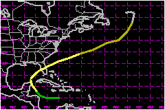
Tropical Storm Keith, a late season storm, was the
fourth named tropical cyclone of the season to affect the Caribbean. Forming
in the central Caribbean, Keith nearly reached hurricane strength as it
passed over the northeastern tip of the Yucutan Peninsula on 21 November.
Keith then became only the second (Floyd
'87) late-season tropical cyclone to strike the southwest Florida coast
since Tropical Storm Jenny in October 1969. After crossing the Florida
peninsula, Keith accelerated to the northeast and became a major north
Atlantic extratropical storm.
a. Synoptic History
Based upon satellite imagery and upper-air soundings, the system
that became Tropical Storm Keith moved westward off the African coast
on 5 November as a tropical wave. The system moved through the Lesser
Antilles on 12 November and slowed as it continued westward into the Caribbean.
A large well-defined 200-mb anticyclone covered the Caribbean and provided
an excellent outflow mechanism for the budding tropical cyclone. On 17
November, ship reports confirmed that a cyclonic circulation seen in the
animation of satellite imagery was indeed on the surface, and the tropical
depression advisories were initiated.
The poorly-organized depression moved slowly westward. On 18
November, satellite imagery revealed a diffuse center removed from the
deep convection. However, synoptic and upper-air data from the western
Caribbean indicated the environment surrounding the depression had become
more supportive for development to occur. By 20 November, deep convection
had developed close to the center of circulation, and the depression began
to move toward the northwest around 12 mph in response to pressure falls
created by an eastward moving trough over the Gulf of Mexico.
As the depression moved toward the northwest, gradual strengthening occurred;
and based upon satellite estimates, the depression was upgraded to Tropical
Storm Keith at 1600 UTC on the 20th. However, in retrospect, the system
probably reached tropical storm strength by 0600 UTC.
The upper-level trough, which had turned Keith to the northwest, had moved
rapidly northeastward by the 21st and failed to capture Keith. As a result,
the storm slowed its forward speed as it crossed the extreme northeast
tip of the Yucutan Peninsula. Keith turned nnorthward and then northeastward
acoss the central Florida peninsula by the morning of 21 November.
Keith maintained tropical storm strength as it crossed central Florida,
with the center moving onshore in the vicinity of Sarasota near 0700 UTC
on 23 November and exiting just north of Melbourne near 1500 UTC. The
storm then accelerated rapidly toward the northeast under the influence
of strong upper flow which surrounded an extremely large upper-level low
centered near Newfoundland. Keith lost its tropical characteristics on
the 24th while passing to the north of Bermuda. On the 26th, Keith became
an intense north Atlantic extratropical storm with sustained hurricane-force
winds while located well to the east of the Canadian Maritime Provinces.
b. Meteorological Statistics
Tropical Storm Keith strengthened to near hurricane force as
it approached the northeast tip of the Yucutan Peninsula. The ship XCMH
located just west of Cozumel reported wind gusts to 92 mph and a surface
pressure of 985 mb on the 21st between 0000 and 0600 UTC. A Second ship
in Puerto Morelos recorded sustained winds of 69 mph with a gust to 92
mph. Numerous reports from Cozumel indicated continuous lightning and
torrential rain occurred during the time of maximum winds.
Keith weakened slightly as its center passed over the extreme northeastern
tip of the Yucutan Peninsula. Due to the increasing westerly shear and
environment of cooler drier air from north of the frontal trough into
the storm's circulation it never regained its former strength. Keith's
central pressure remained near 993 mb on the 22nd as the storm made a
turn toward the northeast. By the time the storm made landfall on the
Florida west coast near Sarasota most of the deep convection had been
sheared to the north of the center.
The central pressure at landfall was near 995 mb and the maximum sustained
winds were near 63 mph with gusts to 81 mph. However, the 81-mph gust
was recorded at an elevation of 250 feet above the ground.
Keith weakened only slightly to 999 mb as it crossed the central Florida
peninsula and immediately began to accelerate toward the northeast as
it emerged into the Atlantic waters. By the time Keith passed within 125
nautical miles north of Bermuda, it had already lost its tropical characteristics.
Bermuda reported a maximum sustained wind of 46 mph from the southwest
and a peak gust of 79 mph from the northwest behind a cold frontal passage
in the wake the the now-extratropical storm.
Extratropical Storm Keith accelerated to a forward speed of near 52 mph
on the 25th as it raced northeastward toward a large Newfoundland low.
On the 26th, in combination with the Newfoundland low, the central pressure
of the extratropical storm deepened to 945 mb. Several ships in the area
reported sustained winds of 69 to 75 mph.
1. Storm Surge Data
Storm surge data indicated a maximum surge of nearly 6 feet
occurred at isolated locations from point of landfall to as far south
as the Fort Myers area. The storm surge observed was generally in the
range of 3 to 4 feet. Little if any surge was experienced north of the
point of landfall and a minimal surge (1 to 2 feet) occurred along the
northeast Florida and Georgia coasts.
2. Rainfall Data
A maximum rainfall amount of slightly more than 11 inches
was recorded in Largo, Florida, with several other amounts in the 9-10
inch range just to the north of the point of landfall. Elsewhere to the
north of the storm's track across the state amounts ranged from 4 to 7
inches. Rainfall to the south of the track was generally less than 1.5
inches.
3. Tornadoes
Two tornadoes were reported in St. Petersburg at 0532 and
0550 UTC, a few hours prior to the center of Keith making landfall.
c. Casualty and Damage Statistics
There were no reported deaths due to Tropical Storm Keith.
Total damage estimates in Florida were near $3 Million,
most of which can be attributed to storm surge action along the immediate
west coast. Lee County officials estimated total damages for Lee County
alone would be near $1.5 Million. Inland
away from the immediate coast, damage was mostly in the form of isolated
fresh-water flooding, power outages and downed trees.
No casualty or damage information was received from Mexico. Flooding in
western Cuba did considerable damage to the tobacco and vegetable crops
but no dollar figures were available.
Maximum Intensity For Tropical
Storm Keith
17 - 26 November, 1988
Date/Time
(UTC) |
Position |
Pressure
(mb) |
Wind Speed
(mph) |
Stage |
| Lat. (°N) |
Lon. (°W) |
| 26/0600 |
52.0 |
42.0 |
945 |
75 |
Extratropical Storm |
Landfall for Tropical
Storm Keith
17 - 26 November, 1988
Date/Time
(UTC) |
Pressure
(mb) |
Wind Speed
(mph) |
Stage |
Landfall |
| 21/0800 |
993 |
70 |
Tropical Storm |
Cancun,
Mexico |
| 23/0700 |
995 |
65 |
Tropical Storm |
Sarasota,
Florida |
|