1988 PRELIMINARY
REPORTS
Tropical Storm Alberto (TS)
Tropical Storm Beryl (TS)
Tropical Storm Chris (TS)
Hurricane Debby (1)
Tropical Storm Ernesto (TS)
Hurricane Florence (1)
Hurricane Gilbert
(5)
Hurricane Helene (4)
Tropical Storm Isaac (TS)
Hurricane Joan (4)
Tropical Storm Keith
|
a. Synoptic History
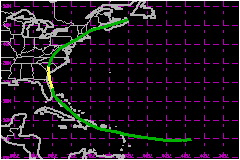
Chris was first detected as a tropical wave near the west
coast of Africa on 15 August. It became a tropical depression on the 21st
in the tropical Atlantic midway between Africa and the Lesser Antilles
when a low level cloud circulation was identified on satellite imagery.
The track is a smooth parabola in the shape of the periphery of the Atlantic
subtropical surface high pressure ridge. Chris remained a depression for
seven days as it moved from the tropical Atlantic across portions of the
Lesser and Greater Antilles and over the Bahamas. It became a tropical
storm for only twelve twelve hours, during which time it moved inland
near Savannah, Georgia.
Satellite analyes indicated that a tropical cyclone was being tracked
from the 21st until landfall on the 28th. However, 13 seperate investigative
reconnaissance flights on the 23rd through the 27th were usable to fid
a well defined low level circulation during this time. Also, even though
many of the satellite intensity estimates were for tropical storm status,
surface and reconnaissance observations clearly showed that surface wind
speeds were below 40 mph.
Finally, on the 28th, reconnaissance aircraft located a low level circulation
center at 0600 UTC just east of Melbourne, Florida and a ship located
about 50 nautical miles northeast of the center reported 46 mph sustained
winds and the system was upgraded to Tropical Storm Chris on this basis.
At 1000 UTC, a tropical storm watch was issued from Edisto Beach, South
Carolina to Cape Hatteras, North Carolina and tropical storm warnings
were issued at 1200 UTC from Savannah, Georgia to Cape Hatteras, North
Carolina.
The system had been moving at about 14 mph for the several days prior
to becoming a tropical storm. However, when it came abeam of Florida,
its motion for the next 24 hours averaged 21 mph and for the period
from 0600 UTC to 1200 UTC on the 28th, its speed of motion was 31 mph.
Perhaps the apparent rapid acceleration was due to the reformation of
the circulation center.
b. Meteorological Statistics
The center of Chris made landfall at 1500 UTC on the 28th
near Savannah, Georgia. The highest observed sustained wind speed was
43 mph at the Savannah Light Tower with an anemometer elevation of 70
feet.
1. Storm Surge Data
Storm surge tides range up to 1.5 feet above normal astronomical
tide levels.
2. Rainfall Data
Rainfall storm totals near the coast were less than 3 inches.
c. Casualty and Damage Statistics
There was 1 deaths attributed to Chris; 1 in South Carolina.
Chris weakened to a depression over South Carolina and then merged with
a front. The surface low pressure system was tracked across the northeastern
U.S. and over to Nova Scotia on the 30th. Inland rainfall amounts ranged
from 3 to 5 inches in a swath from South Carolina to through Pennsylvania
and into Vermont. Strong thunderstorms also accompanied the low center.
One death and one injury resulted from a tornado that destroyed a number
of mobile homes in Clarendon County, South Carolina. Otherwise, in general,
wind damage was minor. The total U.S. damage for this storm is estimated
at $1.5 Million. While near Puerto Rico on
the 24th, the depression dumped 4.5 inches of rain on the island and three
deaths were attributed to the weather.
Maximum Intensity For Tropical
Storm Chris
21 - 30 August, 1988
Date/Time
(UTC) |
Position |
Pressure
(mb) |
Wind Speed
(mph) |
Stage |
| Lat. (°N) |
Lon. (°W) |
| 28/1200 |
30.8 |
80.8 |
1005 |
50 |
Tropical Storm |
Landfall for Tropical
Storm Chris
21 - 30 August, 1988
Date/Time
(UTC) |
Pressure
(mb) |
Wind Speed
(mph) |
Stage |
Landfall |
| 28/1500 |
1005 |
50 |
Tropical Storm |
Savannah,
Georgia |
|