|
|
|
|
|||||||||||||||||||||||||||||||||||
|---|---|---|---|---|---|---|---|---|---|---|---|---|---|---|---|---|---|---|---|---|---|---|---|---|---|---|---|---|---|---|---|---|---|---|---|
|
1988 PRELIMINARY
REPORTS
Tropical Storm Alberto (TS) |
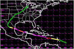
a. Synoptic HistoryOn 3 September a westward moving tropical wave showing no
signs of organization emerged from the northwest African coast over the
open waters of the North Atlantic. During the next several days a broad
low pressure area associated with the tropical wave developed over the
Atlantic midway between Africa and the Lesser Antilles with ship reports
indicating the circulation extended nearly to the equator. An organized
circulation center was not evident on satellite imagery until the system
was approaching the Windward Islands on 8 September. On 9 September the
low was classified by satellite as the 12th tropical depression of the
1988 season when it was located about 400 miles east of Barbados. The depression moved on a west northwest course around 17
mph with satellite and reconnaissance reports indicating that it had
attained tropical storm strength as it moved over the Lesser Antilles
the afternoon of 9 September. Tropical Storm Gilbert rapidly strengthened
on 10 September and was classified as a hurricane by that evening. Gilbert continued to strengthen as it brushed the south coast
of Hispaniola, then passed directly over the island of Jamaica as a category
3 hurricane on the Saffir-Simpson Scale with sustained winds of 127 mph
and minimum pressure of 960 mb. Following the passage of the center across
Jamaica, Gilbert went through a remarkable intensification period with
the pressure falling from 960 mb to 888 mb in 24 hours. The 888 mb pressure
was observed by a NOAA plane near 19.5�N and 83.3�W at 2152 UTC on 13
September and is the lowest sea level pressure ever recorded in the Western
Hemisphere. At the same time the plane measured 184 mph sustained winds
at 10,000 feet with a peak wind of 199 mph. During the period of rapid
strengthening Gilbert continued on a west northwest course at 17 mph
under the influence of a persistent high pressure to the north. The center
passed a short distance southeast of Grand Cayman Island with a wind gust
of 156 mph recorded there at 1900 UTC. The center of Gilbert crossed over the northeast of the Yucatan
Peninsula on 14 September as a category 5 hurricane, the first category
5 hurricane to make landfall in the western hemisphere since Camille in
1969. The hurricane lost strength quite rapidly as the eye moved across
the Yucatan Peninsula with the minimum pressure rising to around 950 mb
by the time the center emerged over the southwest Gulf of Mexico. Gilbert
continued on the same west northwest course around 17 mph across the
Gulf and reached the northeast Mexican coast just north of the town of
La Pesca around 2200 UTC on 16 September as a category 3 hurricane. The center of the weakening storm passed south of Monterrey,
Mexico on 17 September then turned toward the north and moved across western
Texas and into Oklahoma as a heavy rain storm on 18 September. It finally
merged with a developing frontal low pressure system over Missouri on
19 September. b. Meteorological StatisticsWeather observations in the three landfall areas were difficult
to obtain. The only weather office to measure the maximum winds in Gilbert
was Kingston, Jamaica which reported winds of 116 mph with gusts to
140 mph. An unofficial report of 121 mph with gusts to 147 mph was
measured by a ham radio operator located 17 miles northeast of Kingston.
There were no official reports of maximum winds near the center in the
landfall areas of Mexico. Along the lower Texas coast winds in the Brownsville
area gusted to 67 mph with gusts to 83 mph reported near Port Isabel
by an observer with a truck mounted anemometer. A gust of 61 mph was
observed by the National Weather Service in Corpus Christi. Likewise no minimum pressure readings in the eye of Gilbert
were reported as it moved ashore in Mexico. the weather office in Kingston
had a minimum pressure of 965 in the eye. The pressure was estimated near
900 mb when the eye of Gilbert moved over Cozumel, Mexico. 1. Storm Surge DataA 15 to 20 foot storm surge likely occured along the immediate
coast near and just to the north of where the center moved inland over
the northeast Yucatan peninsula. A surge of 8 to 13 feet struck the coast
of eastern Mexico near and just to the north of landfall. There was a
report of a 9 foot surge topped by 30 foot waves on the northeast coast
of Jamaica. Tides of 3 to 5 feet above normal were reported along the
Texas coast with a number of low-lying roads under water. There was considerable
beach erosion on Padre Island. See Table 2 for details on meteorological
statistics. 2. Rainfall DataTorrential rains accompanied the hurricane with between 5
and 10 inches falling over the coastal sections and much greater amounts
in the mountainous areas of Jamaica and Mexico. Massive flooding in the
Monterrey, Mexico area caused many of the deaths attributes to Gilbert.
Rains of 2 to 4 inches fell across south Texas with local amounts of more
than 8 inches observed near Aransas Pass. 3. TornadoesAt least 29 tornadoes were observed across south Texas with
most of the damage occurring in the San Antonio area. This total included
10 in the Lower Rio Grande Valley, 5 around Corpus Christi and at least
a half dozen in the San Antonio area. The greatest destruction there occured
at the Air Logistics Center on Kelly Air Force base where a number of
large storage hangers were destroyed with damage estimated near $22
Million. A tornado in Del Rio destroyed 15 homes and damaged 50
others with damage estimated to be nearly $2 Million. c. Casualty and Damage StatisticsThere were 318 deaths attributed to Gilbert; 202 in Mexico,
45 in Jamaica, 30 in Haiti, 12 in Guaemala, 12 in Honduras, 5 in Dominican
Republic, 5 in Venezuela, 3 in Texas, 2 in Costa Rica and 2 in Nicaragua.
Maximum Intensity For Hurricane
Gilbert
Landfall for Hurricane
Gilbert
| ||||||||||||||||||||||||||||||||||