|
|
|
|
|||||||||||||||||||||||||
|---|---|---|---|---|---|---|---|---|---|---|---|---|---|---|---|---|---|---|---|---|---|---|---|---|---|
|
1988 PRELIMINARY
REPORTS
Tropical Storm Alberto (TS) |
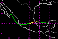
Hurricane Debby, the season's first hurricane, was also one of the shortest lived hurricanes on record. It was a hurricane for only 6 hours before moving ashore just south of Tuxpan, Mexico. The last hurricane to strike that portion of the Gulf Coast of Mexico was Hurricane Anna 1956, another short lived hurricane. In 1955, 3 hurricanes, Gladys, Hilda, Janet, struck that general area. a. Synoptic HistoryA rather strong tropical wave moved off the northwest coast of Africa on 15 August 1988. As the system moved westward across through tropical Atlantic, a detached area of convection in the northern portion of the wave became Tropical Depression Seven east of the Lesser Antilles. This system continued moving west northwestward and later became Tropical Storm Chris near the east coast of Florida. Meanwhile, the southern of the tropical wave continued moving westward across the Caribbean Sea as a disorganized area of showers. Some indications of cloud banding were evident during the night of 29 August with a low level center over the Yucutan Peninsula on the 30th. The low level center emerged over the eastern Bay of Campeche on the 31st and, based on satellite imagery, was classified as a cyclone intensity 1.5 on the Dvorak Scale at 1800 UTC on that date. Thus, it is estimated that Tropical Depression Eight formed near that time. Cloud banding became better organized and the outflow pattern improved on 1 September as the center moved in a general west northwesterly direction under the influence of high pressure centered over the eastern United States. Substantial development took place the next day and the system reached tropical storm strength near 0600 UTC on 2 September based on reconnaissance and satellite observations. Tropical Storm Debby continued moving toward the Tuxpan, Mexico area near 7 mph on 2 September. A reconnaissance report filed at 1701 UTC indicated 92 mph winds at the 1500 feet flight level with 81 mph estimated at the surface. Based on that observation, Debby was upgraded to a hurricane. Since the reported 15 nautical miles diameter center was only 30 nautical miles from the coast at that time, there were no further reconnaissance reports prior to landfall. Thus, based on satellite imagery, it is estimated that little change in strength occured prior to the center making landall about 20 nautical miles south southeast of Tuxpan, Mexico near 0000 UTC on 3 September. Hurricane Debby lost much of its punch over the Sierra Madre
Oriental Mountains of Mexico with the center passing about 45 nautical
miles north of Mexico City. The tight center continued moving toward the
Pacific coast passing offshore between Manzanillo and Puerto Vallarta,
Mexico on 5 September. Upon entering the Pacific, the system became Tropical
Depression Seventeen-E. b. Meteorological StatisticsMeteorological observations are not available from Tuxpan,
Mexico, a city of 120,000, but press reports indicated that heavy rains
produced local flooding and mud slides near the path of Debby. c. Casualty and Damage StatisticsThere were 10 deaths attributed to Debby; 10 in Mexico. About 30,000 people were forced to flee their homes; most being
in the state of Veracruz. Dozens of residents were evacuated from low
lying areas near the Tuxpan and Tecolutla Rivers, and dozens had to be
rescued from cars and flooded homes in Poza Rica.
Maximum Intensity For Hurricane
Debby
Landfall for Hurricane
Debby
| ||||||||||||||||||||||||