|
|
|
|
|||||||||||||||||||||||||||||||||||||||||||||||||
|---|---|---|---|---|---|---|---|---|---|---|---|---|---|---|---|---|---|---|---|---|---|---|---|---|---|---|---|---|---|---|---|---|---|---|---|---|---|---|---|---|---|---|---|---|---|---|---|---|---|
|
2000 PRELIMINARY
REPORTS |
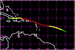
Debby struck the islands of the northeast Caribbean as a 75-mph hurricane, but the impact was not very significant. It appeared that Debby was going to be a significant threat to south Florida, but the system dissipated rather unexpectedly. a. Synoptic HistoryA strong tropical wave moved off the west coast of Africa on 16 August, accompanied by winds to near 58 mph at the 650 mb level over Dakar. The following day, a broad area of low pressure associated with this wave was noted in the vicinity of 10N 30W, but there was insufficient curvature in the associated bands of deep convection for a Dvorak classification of the system. A low-level circulation center was identified by the Tropical Analysis and Forecast Branch (TAFB) at 0000 UTC 18 August, but the system was still considered "too weak to classify". An initial classification was done by TAFB at 1145 UTC on the 18th. By that time the curvature of the convective bands had increased, however the system was still broad and poorly organized. As the disturbance continued westward around 17 mph, it gradually became better organized. By 1800 UTC 19 August the cloud pattern had become consolidated around a well-defined center and it is estimated that the fourth tropical depression of the season developed, about 900 nautical miles east of the Windward Islands. Vertical shear was weak over the area, with anticyclonic outflow developing aloft. In this environment, the cyclone strengthened and became Tropical Storm Debby around 0600 UTC 20 August. A pronounced mid-level ridge to the north of the cyclone maintained a west-northwestward motion. By midday on the 20th, microwave imagery data began to suggest some southwesterly shearing over Debby, with the low-level center displaced a bit to the southwest of the mid- to upper-level center. Nonetheless the storm strengthened further and is estimated to have become a hurricane by 0600 UTC 21 August. By this time the infrared imagery also showed the signature of a sheared system. Even though Debby was not well organized it strengthened even further, and reconnaissance data indicated that its maximum winds increased to 86 mph, which was the peak intensity, a little later on the 21st. Radiosonde data from the Lesser Antilles indicated that the southwesterly shearing may initially have been due to strong lower-tropospheric easterly flow, with the low-level center "outrunning" the mid- to upper-level center. By late on 21 August, the strengthening ceased. Debby was a 75-mph hurricane when its center moved across the extreme northern Leeward Islands from 0600 to 1200 UTC on the 22nd. Continuing west-northwestward, Debby's center moved over the British Virgin Islands around 1500 UTC on the 22nd, and passed about 30 nautical miles off the northeast coast of Puerto Rico a few hours later. By early on the 23rd, southwesterly shearing over Debby increased (dropsonde data from a two-aircraft synoptic flow mission revealed that upper-tropospheric flow was now largely responsible). Although not well organized, the system maintained minimal hurricane strength until around 1200 UTC on the 23rd when the cloud pattern became even more disorganized-looking. The weakening storm turned toward the west and moved along the northern coast of Hispaniola. Although the mountainous land mass of that island may have played some role in the weakening by restricting inflow from the south and disrupting the southern part of the cyclone's circulation, it appears that vertical shear was the main cause for weakening. Around midday on the 23rd, a distinct low-cloud circulation center was evident just to the north of Hispaniola, displaced well to the west of the main area of deep convection. The cyclone continued westward, entering the Windward Passage around 0000 UTC 24 August. It dissipated near the south coast of eastern Cuba on the morning of the 24th. Debby's remnant, a strong tropical wave, continued to track westward, spreading locally heavy showers and gusty winds over Cuba, the Straits of Florida, and southern Florida over the next couple of days.
| ||||||||||||||||||||||||||||||||||||||||||||||||
| Date/Time (UTC) |
Position | Pressure (mb) |
Wind Speed (mph) |
Stage | |
|---|---|---|---|---|---|
| Lat. (°N) | Lon. (°W) | ||||
| 21/1200 | 15.7 | 56.3 | 1004 | 85 | Category 1 Hurricane |
Minimum
Pressure For Hurricane Debby
19 - 24 August, 2000
| Date/Time (UTC) |
Position | Pressure (mb) |
Wind Speed (mph) |
Stage | |
|---|---|---|---|---|---|
| Lat. (°N) | Lon. (°W) | ||||
| 22/0300 | 17.1 | 60.9 | 991 | 80 | Category 1 Hurricane |
Landfall
for Hurricane Debby
19 - 24 August, 2000
| Date/Time (UTC) |
Pressure (mb) |
Wind Speed (mph) |
Stage | Landfall |
|---|---|---|---|---|
| 22/0600 | 993 | 75 | Category 1 Hurricane | Barbuda |
| 22/0915 | 993 | 75 | Category 1 Hurricane | St. Bethelemy |
| 22/1500 | 994 | 75 | Category 1 Hurricane | Virgin Gorda |