|
|
|
|
|||||||||||||||||||||||||
|---|---|---|---|---|---|---|---|---|---|---|---|---|---|---|---|---|---|---|---|---|---|---|---|---|---|
|
2000 PRELIMINARY
REPORTS |
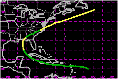
Helene made landfall as a minimal tropical storm near Fort Walton Beach, Florida and redeveloped into a strong tropical storm over the North Atlantic. a. Synoptic HistoryHelene developed from a tropical wave that emerged from the African coast on 10 September. The wave lost all of its deep convection the next day as it continued moving westward. There was little sign of redevelopment until 14 September when convection formed near the center of the system. Showers and thunderstorms continued overnight and Dvorak satellite estimates indicate that Tropical Depression Twelve formed on the afternoon of the 15th. The depression appeared to weaken before aircraft reconnaissance first flew into the system the next day. The aircraft could not find a closed circulation, indicating that the depression had degenerated into a tropical wave. It is notable that, even without any center, the plane reported winds in excess of 63 mph at 1500 ft to the north and east of the wave. The remnants of the depression moved over the Leeward Islands on the 17th, producing heavy rains and gusty winds to tropical storm force in squalls. Upper-level conditions seemed very favorable for regeneration, but the system was slow to redevelop. It was not until late on the 19th that a reconnaissance aircraft found a closed circulation northwest of Grand Cayman Island, while the system was moving more to the west-northwest. The depression was very weak with only a few thunderstorms near the center when it crossed the western tip of Cuba the next day. However, convection redeveloped near the center and it became Tropical Storm Helene early on the morning of the 21st in the southeast Gulf of Mexico. The storm moved northwestward, strengthening under marginally favorable conditions. However, the vertical wind shear increased, preventing Helene from attaining hurricane status. The system became very asymmetric as a result of the shear, with most of its deep convection, winds, and heavy rainfall displaced to the east of the center. It peaked at a maximum intensity of 69 mph about twelve hours before landfall. The shear increased further and weakened Helene to an intensity of 40 mph during landfall near Fort Walton Beach, Florida around 7 am CDT on the 22nd. Helene then moved toward the northeast over the southeastern states as a tropical depression. Even with strong westerly shear, deep convection began to intensify over the coastal waters of North Carolina when the system approached the east coast. Tropical storm force winds were measured at stations off the coast of North Carolina. A post-analysis of buoy data and satellite imagery indicates that Helene had developed enough tropical characteristics to be considered a tropical cyclone as it emerged from the coast of Virginia. The cyclone began to race northeastward away from the United States toward decreasing shear. Ship observations and satellite images indicate the system was very compact over the Atlantic, no more than 120 nautical miles wide with the strongest winds in the south and east quadrants. An intense burst of convection formed over the center on the 24th, and it is estimated that Helene reached a second peak intensity of 69 mph early on the 25th before merging with a cold front later that day.
| ||||||||||||||||||||||||
| Date/Time (UTC) |
Position | Pressure (mb) |
Wind Speed (mph) |
Stage | |
|---|---|---|---|---|---|
| Lat. (°N) | Lon. (°W) | ||||
| 25/0600 | 41.6 | 62.2 | 986 | 70 | Tropical Storm |
Landfall
for Tropical Storm Helene
15 - 25 September, 2000
| Date/Time (UTC) |
Pressure (mb) |
Wind Speed (mph) |
Stage | Landfall |
|---|---|---|---|---|
| 22/1200 | 1006 | 40 | Tropical Storm | Fort Walton Beach, Florida |