|
|
|
|
|||||||||||||||
|---|---|---|---|---|---|---|---|---|---|---|---|---|---|---|---|
|
2000 PRELIMINARY
REPORTS |
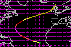
Isaac was a Cape Verde hurricane that followed a long, parabolic path over the eastern half of the Atlantic. Its maximum sustained winds reached an estimated 138 mph, tying it with Keith for the strongest hurricane of the season. a. Synoptic HistoryA strong tropical wave emerged from western Africa on 20 September with some curvature in the associated deep convective clouds. The system produced a very well-defined lower-tropospheric wind shift in the time section from Dakar, Senegal. Later that day, the system was given an initial Dvorak classification. On the following day, the cloud pattern became better organized and a tropical depression (Thirteen) formed, a couple hundred miles to the south of the Cape Verde Islands. A mid-tropospheric ridge was present over the eastern Atlantic to the north of the tropical cyclone, and this provided a west-northwestward steering for several days. Vertical wind shear was weak, and this allowed the system to gradually strengthen into Tropical Storm Isaac by 0000 UTC 22 September. Strengthening continued, and Isaac became a hurricane around 1200 UTC on the 23rd, when a faint eye was evident on visual satellite imagery. Soon thereafter, the eye became much better defined on the images, and the hurricane quickly strengthened to 121 mph by 0000 UTC 24 October. Afterwards on the 24th, the cloud pattern became less organized; core convection became less symmetric and the eye was not as well-defined as it had been the day before. This appeared to be mainly the result of internal fluctuations, as the large-scale atmospheric environment remained favorable. Isaac's winds decreased to about 104 mph on the 25th, when west-southwesterly vertical shear became more evident over the system; slightly cooler ocean waters may have also played a role in the weakening of the hurricane. By around 1200 UTC on the 26th, the low-cloud center of Isaac was near the southwest edge of the main area of deep convection, and the hurricane's winds had decreased to an estimated 86 mph. Later on the 26th, the shear relaxed somewhat, and deep convection became organized more symmetrically around the center. Isaac re-strengthened on the 27th. A distinct eye again became visible, and Isaac re-attained category three status around 0000 UTC 28 September. The hurricane turned toward the northwest about that time. Isaac continued to intensify, and reached its peak strength of 138 mph, category four on the Saffir-Simpson Hurricane Scale, around 1800 UTC on the 28th. Not long after reaching its maximum intensity, the hurricane turned north-northwestward. Continuing its movement around the western periphery of a mid-tropospheric anticyclone, Isaac turned northward and then north-northeastward. The center passed about 440 nautical miles east of Bermuda on the 29th. When the cyclone moved over cooler waters, the maximum winds gradually decreased, and were down to category one intensity on the 30th. By this time, Isaac was accelerating northeastward. The system weakened to a tropical storm on 1 October, and became extratropical later that same day. Isaac's remnant, a strong extratropical cyclone with winds of 63 to 69 mph, moved rapidly east-northeastward over the Atlantic. By 3 October, the cyclone turned north-northeastward, skirting the western British Isles. The system's maximum winds had decreased to near 52 mph by this time. Early on 4 October, the cyclone merged with a larger extratropical low to the north of Scotland.
| ||||||||||||||
| Date/Time (UTC) |
Position | Pressure (mb) |
Wind Speed (mph) |
Stage | |
|---|---|---|---|---|---|
| Lat. (°N) | Lon. (°W) | ||||
| 28/1800 | 26.6 | 54.2 | 943 | 140 | Category 4 Hurricane |