|
|
|
|
|||||||||||||||||||||||||||||||||||
|---|---|---|---|---|---|---|---|---|---|---|---|---|---|---|---|---|---|---|---|---|---|---|---|---|---|---|---|---|---|---|---|---|---|---|---|
|
2000 PRELIMINARY
REPORTS |
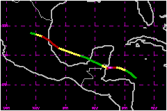
Keith was a rapidly-intensifying tropical cyclone over the northwestern Caribbean Sea, reaching Category 4 on the Saffir-Simpson Hurricane Scale as it stalled just off the coast of Belize. Keith affected the coastal islands of Belize as a Category 3 hurricane, but weakened to a tropical storm before actually making landfall in mainland Belize. After weakening to a tropical depression while crossing the Yucatan Peninsula, Keith re-intensified over the southwestern Gulf of Mexico and made landfall in northeastern Mexico as a Category 1 hurricane. a. Synoptic HistoryA tropical wave moved off the west coast of Africa on 16 September. The wave showed signs of organization over the Atlantic from 19-22 September, but strong vertical shear prevented development then. The wave continued westward into the Caribbean Sea and started to become better organized on 27 September, when the first Dvorak satellite intensity estimate was made. Development continued, and an Air Force Reserve Hurricane Hunter aircraft found that the system became a tropical depression about 60 nautical miles north-northeast of Cape Gracias a Dios, Nicaragua, around 1800 UTC 28 September. The depression moved northwestward, and a second flight around 1800 UTC 29 September indicated that the cyclone had become Tropical Storm Keith. Rapid intensification began near that time, and Keith's central pressure fell from 1000 mb at 1814 UTC on the 29th to 939 mb at 0708 UTC 1 October -- a 61 mb fall in about 37 h. A 38 mb fall occurred from 1808 UTC on the 30th to the time of minimum pressure, which qualifies as explosive deepening as defined by Dunnavan (1981). Maximum winds reached 138 mph -- Category 4 on the Saffir-Simpson hurricane scale near the time of minimum pressure. During this rapid development, Keith slowed and turned westward, with the eye moving to a position just southeast of the coastal islands of Belize. A slight weakening occurred later on the 1st, and Keith was a Category 3 hurricane when the eyewall moved over Ambergris Cay and Caye Caulker, Belize near 1800 UTC. Motion then became slow and erratic, with the eye of Keith meandering just off the Belize coast into 3 October. This was partly due to high pressure over the Gulf of Mexico blocking the hurricane's path, and partly due to formation of a tropical disturbance (later to become Tropical Storm Leslie) near western Cuba. The cyclone weakened dramatically during this time. Keith was a Category 1 hurricane when the center crossed Ambergris Cay, Belize near 2300 UTC on the 2nd and a 69-mph tropical storm when the center crossed the Belize mainland coast between Belize City and Chetumal, Mexico around 0300 UTC on the 3rd. Once inland, Keith began moving west-northwestward, and this direction of general motion continued with a gradual acceleration until its final landfall. It weakened to a depression over the Yucatan Peninsula, then re-intensified to a tropical storm over the Bay of Campeche on 4 October. Keith regained hurricane status on 5 October, and maximum winds increased to 91 mph as the hurricane made landfall about 20 nautical miles north of Tampico Mexico around 1800 UTC that day. Keith again weakened over land, and the cyclone dissipated over northeastern Mexico the next day.
| ||||||||||||||||||||||||||||||||||
| Date/Time (UTC) |
Position | Pressure (mb) |
Wind Speed (mph) |
Stage | |
|---|---|---|---|---|---|
| Lat. (°N) | Lon. (°W) | ||||
| 01/0700 | 17.9 | 87.3 | 939 | 140 | Category 4 Hurricane |
Landfall
for Hurricane Keith
28 September - 06 October, 2000
| Date/Time (UTC) |
Pressure (mb) |
Wind Speed (mph) |
Stage | Landfall |
|---|---|---|---|---|
| 02/2300 | 988 | 75 | Category 1 Hurricane | Ambergris Cay, Belize |
| 03/0300 | 990 | 70 | Tropical Storm | Belize City, Belize |
| 05/1800 | 980 | 90 | Category 1 Hurricane | Tampico, Mexico |