|
|
|
|
|||||||||||||||
|---|---|---|---|---|---|---|---|---|---|---|---|---|---|---|---|
|
2000 PRELIMINARY
REPORTS |
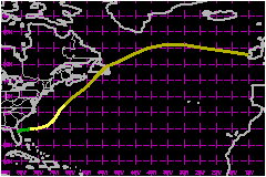
Leslie was a short-lived tropical storm that developed from Subtropical Depression One off the east coast of Florida, and subsequently moved northeastward over the western Atlantic. Although neither Leslie nor the subtropical depression was responsible for any damage or casualties, a precursor disturbance combined with a stalled frontal boundary to produce very heavy rainfall, and flood damage estimated at $700 Million in southeast Florida on 2-3 October. Three deaths in south Florida were indirectly attributable to the flooding. a. Synoptic HistoryThe immediate precursor to Tropical Storm Leslie was a subtropical depression that had formed inland near the east coast of central Florida at 1200 UTC 4 October. Ironically, the disturbance that led to the subtropical cyclone was a tropical wave that entered the eastern Caribbean Sea on 27 September. Although its signature in satellite imagery was extremely weak prior to this point, this was likely the same tropical wave that spawned Hurricane Isaac. Upon entering the Caribbean Sea, the wave was accompanied by disorganized and sporadic thunderstorm activity over northern sections of South America. On 29 September, the tropical wave and accompanying thunderstorm activity moved north-northwest off the coast of Columbia into the central Caribbean Sea. For the next two days, the disorganized cluster of thunderstorms moved to the north-northwest around the circulation of Hurricane Keith, which at that time was located in the northwest Caribbean Sea. By 1200 UTC 2 October, a distinct mid-level circulation was evident in satellite imagery just south of western Cuba, near the Isle of Youth. This circulation moved northward across western Cuba and the Straits of Florida, and by 1200 UTC 3 October it entered the extreme southeast Gulf of Mexico. Dvorak satellite classifications by the Tropical Analysis and Forecast Branch (TAFB) and the Satellite Analysis Branch (SAB) began at 0600 UTC on the 3rd. Satellite and radar images showed a large area of showers and thunderstorms that extended east of the mid-level circulation center from the Florida Straits northward across the Florida Keys into extreme south Florida. During the early afternoon of 3 October, a NOAA reconnaissance aircraft investigated the disturbance in the southeast Gulf of Mexico, and found an elongated trough of low pressure at a flight-level of 1500 ft but no well-defined surface circulation center. As the disturbance moved north towards the west coast of Florida, it interacted with a stalled frontal boundary across southern Florida. During the afternoon and evening of 3 October, a band of very heavy rainfall became stationary across southeast Florida. Widespread rainfall, with accumulations of 12 to 18 inches, occurred in a swath extending from southwest Miami-Dade county to extreme southeast Broward County, and two (F0) tornadoes touched down in Miami-Dade County. After 0000 UTC 4 October, the mid-level circulation began moving northeast and passed near Sarasota, Florida around 0600 UTC; however, the associated shower and thunderstorm activity remained well southeast of the disturbance in the frontal trough. Surface observations show the remnants of the frontal trough remaining over south Florida for several hours after the passage of the mid-level circulation center. They also show that by 1200 UTC on the 4th, as the mid-level center continued northeastward over central Florida, an associated well-defined surface low and circulation developed just east of Orlando. At this time the convection was still located well southeast of the surface low, with the strongest winds approximately 150 nm from the center. Given this structure, as well as the presence of a nearby upper-level short wave trough that may have assisted in the development, the system at this stage is considered to have been a subtropical depression. At 1800 UTC on the 4th, the depression moved just offshore near Daytona Beach, Florida (at which point it received a subtropical cyclone classification, ST 1.5, by TAFB). Reconnaissance data at this time confirmed that the strongest flight level winds (35 to 40 mph) remained well southeast of the center. Subtropical Depression One moved slightly north of east at 9 mph overnight, and early-morning satellite imagery on the 5th suggested that the low-level center was located closer to the deep convection. Reconnaissance data near 1200 UTC 5 October confirmed that the wind field had contracted, and that the maximum flight-level winds (51 mph) were within 75 nm of the center. On this basis Subtropical Depression One was upgraded to Tropical Storm Leslie, about 200 nautical miles east of St. Augustine, Florida. Leslie remained a weak tropical storm as it moved to the east-northeast on the 5th, briefly threatened Bermuda but turned to the northeast early on the 7th and passed about 250 miles to the west of the island. The circulation of Leslie began to elongate and became entangled with a cold frontal boundary, and the cyclone became extratropical by 1800 UTC on the 7th, when it was about 325 nautical miles north-northwest of Bermuda. The remnant extratropical low moved rapidly northeastward, crossing Newfoundland late on the 8th, and was tracked for another day or so as it raced east-northeastward across the North Atlantic.
| ||||||||||||||
| Date/Time (UTC) |
Position | Pressure (mb) |
Wind Speed (mph) |
Stage | |
|---|---|---|---|---|---|
| Lat. (°N) | Lon. (°W) | ||||
| 10/1800 | 53.0 | 10.0 | 973 | 70 | Extratropical Storm |