|
|
|
|
|||||||||||||||
|---|---|---|---|---|---|---|---|---|---|---|---|---|---|---|---|
|
2000 PRELIMINARY
REPORTS |
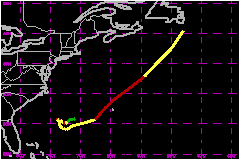
Hurricane Florence was a category one hurricane (on the Saffir-Simpson Hurricane Scale) of subtropical origins that passed within about 65 nautical miles of Bermuda. a. Synoptic HistoryDuring the first week of September a cold front edged off the North American continent and became stationary over the western subtropical Atlantic. A weak wave along the front amplified slowly on the 8th and 9th of September, and then began to deepen more rapidly on the 10th underneath an upper-level cold low. During the day the flow around the developing low became less wavelike and more circular, and it is estimated that the low had lost its surface frontal structure and become a subtropical depression by 1800 UTC on the 10th, when it was about 325 miles west-southwest of Bermuda. At this time convection was present west of and close to the circulation center, but very limited in areal coverage. It is presumed that the upper circulation was still cold-core, hence the subtropical designati on. After 0000 UTC on the 11th, the convection began to increase in depth and coverage as it rotated to the south side of the low-level circulation center. An Advanced Microwave Sounder Unit (AMSU) temperature cross-section analysis from the Cooperative Institute for Research in the Atmosphere (CIRA) suggests a weak warm core had developed by 1243 UTC on the 11th, and it is estimated that the subtropical depression had become tropical (or at least sufficiently so to warrant the designation) by 0600 UTC. The convective burst early on the 11th continued to rotate around to the east side of the low-level circulation center where it was associated with a rapid increase in wind speed. The depression reached tropical storm strength by 1200 UTC and hurricane strength by 1800 UTC that day, the latter event occurring when Florence was about 425 nautical miles west-southwest of Bermuda. However, the strong winds were confined to a very small area near the edge of the convection, and after 0000 UTC on the 12th, when the cyclone entrained some drier mid-tropospheric air and the convection collapsed, Florence's winds temporarily weakened below hurricane strength. A reconnaissance aircraft later on the 12th reported pressure falls, the development of an elliptical eyewall, and a return of hurricane force winds. On the 11th, Florence moved very slowly westward under the influence of a middle-level ridge along the mid-Atlantic coast; however, this flow was soon balanced by ridging to the southeast of the cyclone and Florence moved little from the 12th to the 14th. By 1200 UTC on the 13th central pressures began to rise and Florence again weakened to a tropical storm, due in part perhaps to local reduction of the sea-surface temperatures under the hurricane. (Sea-surface temperature analyses from Johns Hopkins University Applied Physics Laboratory show decreases of up to 6C near the cyclone center during this time.) North-northwesterly shear began to increase as well on the 14th, and the maximum winds dropped to 46 mph. An approaching short-wave trough in the westerlies broke the steering stalemate and began to accelerate Florence to the east-northeast on the 15th. With most of the convection and strong winds in its southeast quadrant, Florence strengthened late on the 15th, turned rapidly to the northeast, and attained hurricane strength for the third time at 0000 UTC on the 16th, when it was about 175 nautical miles west-southwest of Bermuda. Florence made its closest approach to Bermuda, passing about 65 nautical miles to the northwest of the island, around 0800 UTC on the 16th. Later on the 16th an eye was briefly apparent as Florence reached its peak intensity of 81 mph. Weakening ensued over cooler waters, and Florence became a tropical storm for the fourth time at 0000 UTC on the 17th, when it was about 425 nautical miles northeast of Bermuda. After 1800 UTC on the 17th, when it was about 125 nautical miles south of St. Johns Newfoundland, the circulation of Florence was absorbed by the extratropical surface low associated with the short wave trough.
| ||||||||||||||
| Date/Time (UTC) |
Position | Pressure (mb) |
Wind Speed (mph) |
Stage | |
|---|---|---|---|---|---|
| Lat. (°N) | Lon. (°W) | ||||
| 16/1800 | 36.1 | 61.8 | 985 | 80 | Category 1 Hurricane |