|
|
|
|
|||||||||||||||||||||||||
|---|---|---|---|---|---|---|---|---|---|---|---|---|---|---|---|---|---|---|---|---|---|---|---|---|---|
|
2000 PRELIMINARY
REPORTS |
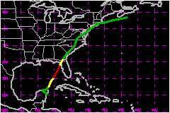
Gordon became a category one hurricane on the Saffir-Simpson Hurricane Scale over the eastern Gulf of Mexico, but eventually made landfall in the Florida Big Bend area as a weakening tropical storm. a. Synoptic HistoryA tropical wave moved off the west coast of Africa on 4 September and tracked westward across the tropical Atlantic. Little or no deep convection was associated with the wave until 8 September when the wave was located about 600 nautical miles east of the Lesser Antilles. The tropical wave moved through those islands on 9-10 September bringing locally heavy rainfall and wind gusts of 29 to 35 mph. The wave tracked west-northwestward and developed centralized convection near the vorticity center over the central Caribbean Sea on the 12th. Satellite classifications from the Tropical Analysis and Forecast Branch (TAFB) and the Satellite Analysis Branch (SAB) began around 0000 UTC 13 September. They indicated the convection was poorly organized. However, by 1800 UTC surface observations indicated a broad low pressure area had developed along the wave axis about 100 nautical miles southeast of Cozumel, Mexico. At 0000 UTC 14 September, Dvorak satellite intensity estimates from the TAFB, SAB, and the Air Force Weather Agency (AFWA) suggested the broad low pressure system was near tropical depression strength, but the overall convective pattern was still poorly organized. Tropical Depression Eleven formed about midway between Cozumel and Chetumal, Mexico on the morning of 14 September based on a U. S. Air Force Reserve (USAFR) reconnaissance aircraft report of a broad closed circulation and 36 mph flight-level (1500 ft) winds. By 2100 UTC, the depression's low-level center had moved inland over the eastern Yucatan Peninsula, while the more pronounced mid-level circulation was located about 10 nautical miles to the northeast. This decoupled pattern persisted for more than 24 hours while the depression tracked slowly northwestward across the northern Yucatan Peninsula. Late on 15 September, an Air Force Reserve reconnaissance aircraft indicated the depression had moved off the north coast of the Yucatan and over the warm waters of the Gulf of Mexico. Aircrew reported the low- and mid-level circulations had become vertically aligned, 68 mph flight-level (1500 ft) winds, and a minimum pressure of 1003 mb. At 0000 UTC 16 September, the depression had strengthened into Tropical Storm Gordon. Once over the warm Gulf waters, Gordon moved steadily northeastward toward the Florida Big Bend area and slowly intensified. A report of easterly winds of 74 mph from ship MYMX5 located about 30 nautical miles northeast of the center indicated that Gordon had become a hurricane by 0000 UTC 17 September. Only slight strengthening continued for another 6 hours and Gordon eventually peaked at 81 mph. After peaking on the 17th about 165 nautical miles southwest of Tampa, Florida, slow weakening began as moderate southwesterly upper-level winds ahead of an approaching mid-tropospheric trough began to increase the vertical shear across the hurricane. Water vapor imagery and surrounding upper-air data indicated that mid-level dry air entrainment from the south also helped the weakening process. The dry air helped erode the outer cloud and precipitation shield and gradually wrapped into the inner core of the hurricane. Within a few hours, the dry slot had worked its way counter-clockwise completely around the eye and by 1328 UTC reconnaissance reports indicated the minimum surface pressure had risen sharply to 990 mb. Gordon was downgraded to a tropical storm at 1800 UTC 17 September. It continued to track northeastward and eventually made landfall just northwest of Cedar Key, Florida, at 0300 UTC 18 September, as a tropical storm with 63 mph winds. After landfall, interaction with land and cool, stable air north of a weak frontal boundary hastened the weakening process. At 1200 UTC the same day, Gordon weakened into a tropical depression. By 1800 UTC, it merged with the front and extratropical transition occurred over southeast Georgia. Gordon's remnant low-level circulation then moved northeastward up the east coast of the United States for the next 3 days before being absorbed by a large extratropical low pressure system over eastern Canada around 1200 UTC 21 September. Owing to the lack of any significant baroclinic effects, only modest rainfall totals and no significant flooding were observed over the mid-Atlantic and northeast regions of the United States.
| ||||||||||||||||||||||||
| Date/Time (UTC) |
Position | Pressure (mb) |
Wind Speed (mph) |
Stage | |
|---|---|---|---|---|---|
| Lat. (°N) | Lon. (°W) | ||||
| 17/0600 | 26.1 | 84.9 | 981 | 80 | Category 1 Hurricane |
Landfall for Hurricane Gordon
14 - 21 September, 2000
| Date/Time (UTC) |
Pressure (mb) |
Wind Speed (mph) |
Stage | Landfall |
|---|---|---|---|---|
| 18/0300 | 991 | 65 | Tropical Storm | Cedar Key, Florida |