|
|
|
|
|||||||||||||||
|---|---|---|---|---|---|---|---|---|---|---|---|---|---|---|---|
|
1990 PRELIMINARY
REPORTS |
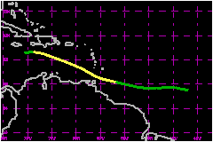
a. Synoptic HistoryThe origin of Arthur was a tropical wave that moved off the coast of Africa on 18 July. The wave consisted of a fairly concentrated area of thunderstorms centered at the low latitudes of 10°N. The wave moved westward at 17 to 23 mph. On the 22nd, near 43°W longitude, the wave was upgraded to Tropical Depression Two based on interpretation of satellite imagery. The depression continued mostly westward with minor fluctuations
in intensity and on the 24th was upgraded to Tropical Storm Arthur while
centered about 250 nautical miles east of Trinidad. This was based on
an Air Force reconnaissance flight as well as satellite imagery which
showed an increase in convection and banding. b. Meteorological StatisticsIn addition to the routine satellite intensity and position
estimates from the Tropical Satellite and Forecast Unit, the Satellite
Analysis Branch and the Air Force Global Weather Center, there were five
Air Force reconnaissance missions. The first reconnaissance mission was
on the 24th when the system was just east of the Windward Islands. This
flight reported a maximum flight level wind speed of 47 mph just northeast
of the center at an altitude of 1500 feet. A maximum surface wind of 46
mph was estimated on this same flight along with 1005 mb surface pressure.
This data in combination with satellite intensity estimates were the bases
for upgrading the depression to Tropical Storm Storm Arthur. Soon after,
at 0000 UTC on the 25th, the ship PGDS reported a 40-mph wind speed
at a location about 60 nautical miles north of the center. The storm center
passed near the island of Grenada at 0800-0900 UTC and the maximum 1-minute
wind speed reported there was 30 mph with a gust to 55 mph and the minimum
surface pressure was 1002 mb. Winds at Trinidad and Tobago, located to
the south of the center went from 340° at 3 mph to 200° at 2 mph
to 150° at 14 mph as the storm center passed by to the north. c. Casualty and Damage StatisticsNone have been reported Maximum Intensity For Tropical
Storm Arthur
| ||||||||||||||