|
|
|
|
||||||||||||||||||||||||||||||
|---|---|---|---|---|---|---|---|---|---|---|---|---|---|---|---|---|---|---|---|---|---|---|---|---|---|---|---|---|---|---|
|
1990 PRELIMINARY
REPORTS |
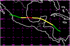
a. Synoptic HistoryDiana formed from a classical tropical wave which moved off Africa on 27 July and represented a typical example of developing disturbances over the Atlantic basin. The wave moved through the southern Windward Islands with a marked wind shift and a concentrated area of about 3.5 mb 24-hour pressure change. The wave had its maximum amplitude at the mid-levels and was accompanied by a strong upper level anticyclone reflected in the upper air data from the Lesser Antilles. The first Air Force reconnaissance plane flew into the area when the wave was in the extreme southeastern Carribean and found squalls but no low-level circulation. Satellite pictures suggested that the system continued to be accompanied by a large area of thunderstorms. Surface and satellite observations indicated that the most active area was moving along the South American coast directly over the Netherland Antilles. On 4 August, high resolution satellite images indicated cyclonic rotation in the low clouds and deep convection covering a large portion of the western Caribbean, suggesting that a tropical depression was forming near the eastern tip of Honduras. That was confirmed by limited surface observations and by an Air Force plane which indeed found an incipient 1008 mb center later that day. The depression rapidly reached tropical storm intensity while
moving northwestward, under the influence of a middle level pressure trough
in the Gulf of Mexico. Diana crossed the Yucutan peninsula and then took
a more westerly track as the trough of low pressure in the Gulf weakened.
Diana continued to intensify and reached category two hurricane status
on 7 August near 95°W prior to landfall near Tuxpan, Mexico. After
moving inland, Diana was declared dissipated by 1200 UTC on 8 August over
western Mexico. However, a post-storm analysis indicated that a low pressure
area with some convection persisted until 1200 UTC 9 August over the Eastern
Pacific northwest near Puerto Vallarta. b. Meteorological StatisticsIn addition to the constant satellite surveillance, there were
4 Air Force reconnaissance missions after the system was declared a tropical
depression. Daily checks were performed while the system traveled over
the Caribbean as a strong tropical wave. The first Air Force plane center
fix was on 5 August when the system was in the Gulf of Honduras. The plane
reported 1003 mb and a maximum flight level wind of 53 mph northeast of
the center. Ship observations over the northwest Caribbean indicated that
Diana was becoming better organized and that the storm had a large circulation.
Ship H9UM traveling from Puerto Cortes, Honduras to Las Minas,
Panama reported 35 to 40 mph, 8-feet swells from the east-southeast and
numerous showers and thunderstorms on 5 August when Diana was in developing
stage. Merida, on the northwest tip of Yucutan, reported sustained winds
of 35 mph with gusts to 40 mph, and heavy rain for several hours on 6
August, as the storm passed south of that location. c. Casualty and Damage StatisticsThere were 96 deaths attributed to Diana; 96 in Mexico.
Maximum
Intensity For Hurricane Diana
Landfall
for Hurricane Diana
| |||||||||||||||||||||||||||||