|
|
|
|
|||||||||||||||
|---|---|---|---|---|---|---|---|---|---|---|---|---|---|---|---|
|
1990 PRELIMINARY
REPORTS |
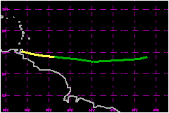
a. Synoptic HistoryTropical Storm Fran moved from Africa into the eastern Atlantic on 9 August as a low-latitude tropical wave. It quickly showed signs of circulation on METEOSAT imagery as satellite classifications began on the 10th with a center position estimate located about 200 nautical miles south of the Cape Verde Islands. The wave was upgraded to Tropical Depression Seven on the 11th. The depression was embedded in deep strong easterlies and it scooted westward across the tropical Atlantic at 23-29 mph, remaining south of 10°N. By 0600 UTC on the 12th, the depression was nearing tropical storm strength as indicated by satellite intensity estimates. However, later in the day, the depression began to lose its circulation and its deep convection. It became "too weak to classify" using the Dvorak technique and was downgraded to an open tropical wave. About 24 hours later, the system again became a little better organized. At 1700 UTC on the 13th, a ship report from LQLW was received which showed a sustained southeasterly wind of 43 mph. The ship was estimated to be 45 nautical miles north of the circulation center at the time of the observation. Based on this report, the wave was upgraded to Tropical Storm Fran on the 2200 UTC advisory and tropical storm warnings were issued for portions of the southern Windward Islands. The minimal storm moved across the extreme southern Windward
Islands on the morning of the 14th and, with half its circulation over
Venezuela, Fran quickly dissipated. b. Meteorological StatisticsTrinidad reported a sustained wind of 40 mph and a surface
pressure of 1007.8 mb at 1200 UTC on the 14th as the storm center passed
just south. It is interesting that satellite intensity estimates from
TSAF, SAB and AFGWC all remained below tropical storm force during the
24 hours that Fran was of tropical storm status. An Air Force reconnaisance
mission on the 14th was also unable to find any tropical storm-force wind
speeds at an altitude of 5000 feet as Fran moved across the Windward Islands.
c. Casualty and Damage StatisticsNone have been reported.
Maximum
Intensity For Tropical Storm Fran
| ||||||||||||||