|
|
|
|
|||||||||||||||
|---|---|---|---|---|---|---|---|---|---|---|---|---|---|---|---|
|
1990 PRELIMINARY
REPORTS |
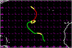
a. Synoptic HistoryJosephine originated from a tropical wave which moved off the African coast on 16 September. The wave had considerable amount of convective activity associated with it as it moved westward. The Tropical Satellite Analysis and Forcast Unit of the NHC began to classify the system at 0000 UTC 20 September, and forecasters at the NHC issued the first advisory on Tropical Depression Twelve at 1000 UTC 21 September. A 200-mb cut-off low located to the west of Gibraltar had deepened to the surface by 21 September and the depression immediately turned northward toward the weakness. During the next few days the surface low weakened and by 24 September surface high pressure began building from the west across to the north of the depression. It immediately turned toward the west and strengthened to a tropical storm. A strong 200-mb trough located to the northwest produced shearing over the storm on 25 September and Josephine weakened to depression strength by 0600 UTC 26 September. By 28 September a broad weak trough located over the northwest
Atlantic caused the depression to turn toward the northwest, and Tropical
Depression Josephine spent the next two days moving toward the weakness
in the pressure field. By 30 September the trough had moved eastward and
Josephine turned toward the north and northeast into the wake of the weak
eastward-moving trough. The trough was too weak to capture the depression.
By 2 October it became readily apparent that the next high pressure center
in the westerlies which had moved off the Canadian Maritimes had begun
to block Josephine's escape to the northeast. Josephine reintensified
to tropical storm strength as the high pressure forced the storm into
a 360° clockwise turn during the following three days.
| ||||||||||||||
| Date/Time (UTC) |
Position | Pressure (mb) |
Wind Speed (mph) |
Stage | |
|---|---|---|---|---|---|
| Lat. (°N) | Lon. (°W) | ||||
| 05/1800 | 34.1 | 38.4 | 980 | 85 | Category 1 Hurricane |