|
|
|
|
|||||||||||||||
|---|---|---|---|---|---|---|---|---|---|---|---|---|---|---|---|
|
1990 PRELIMINARY
REPORTS |
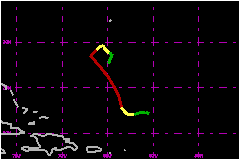
Nana makes 1990 the most active season since 1969. a. Synoptic HistoryThe 14th named system of the 1990 Atlantic season developed from a vigorous tropical wave which moved over the cape Verde Islands on 7 October. Surface and upper-air data from the islands revealed that the wave produced squalls and a marked 52-mph wind shift at the low levels. Data also indicated that the upper-level conditions were not favourable for development, since the westerlies were already establieshed in that region. The wave travelled westward for the next several days in tandem with a broad upper-level trough to its west and maintained deep but disorganised convection. On 13 October, the wave reached the Lesser Antilles and its northern portion moved northwestward while the southern sector continued westward through the Caribbean. The northern portion of the wave became convectively active in the vicinity of high-level divergence provided by a deepening upper level trough. The convection became organized as the trough moved out of the area and the shear relaxed. Finally, on 16 October, satellite images and data from an Air Force plane indicated that a tropical depression had developed about 360 nautical miles northeast of Puerto Rico. The depression intensified rapidly and at 1800 UTC 17 October the system had already reached hurricane status. Nana moved toward the north-northwest track and became a threat
to Bermuda. However, the threat was short lived because a new impulse
of upper level westerlies moved across the hurricane and seperated the
convection from its low-level center. Consequently, Nana weakened to a
tropical depression and drifted in a southerly direction, steered by the
low level flow until it dissipated at 1800 UTC 21 October. The remnants
of Nana were depicted on satellite images for the next few days as a westward
moving swirl of low clouds with transient convection. b. Meteorological StatisticsNana was a very small hurricane. During a flight on 18 October
when Nana was still on developing stage the Air Force plane reported a
closed 8 nautical mile diameter eyewall and estimated surface winds of
109 mph in a very small area north of the eye. The Air Force crew reported
textually " surface pressure dropped like a rock at the time we exited
the eye " at 1146 UTC 18 October when Nana was still in a developing
stage. The reported winds were stronger than would be expected for a system
with the measure minimum pressure. However, those reports and the comments
from the crew were the primary basis for classifying Nana as a hurricane. c. Casualty and Damage StatisticsNone have been reported.
Maximum
Intensity For Hurricane Nana
| ||||||||||||||