1990 PRELIMINARY
REPORTS
Tropical
Storm Arthur (TS)
Hurricane Bertha (1)
Tropical Storm Cesar (TS)
Hurricane Diana (2)
Tropical Storm Edouard (TS)
Tropical Storm Fran (TS)
Hurricane Gustav (3)
Tropical Storm Hortense (TS)
Hurricane Isidore (2)
Hurricane Josephine (1)
Hurricane Klaus (1)
Hurricane Lili (1)
Tropical Storm Marco (TS)
Hurricane Nana (1)
|
a. Synoptic History
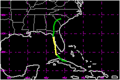
Early on 9 October, Tropical
Storm Klaus was located east of the Bahamas, moving northwest,
and becoming poorly organized. At the same time, a cold low aloft was
developing over Cuba. By 1200 UTC on 9 October, Klaus
had dissipated and the new low had developed downward to the surface over
central Cuba. This new low was designated Tropical Depression Fifteen
near Caibarien, Cuba.
The depression moved west-northwest along the north coast of
Cuba, and then turned toward the northwest over the Florida Straits. The
system became Tropical Storm Marco at 0600 UTC on 10 October while centered
about 30 nautical miles south-southwest of Key West, Florida. After passing
midway between the Dry Torugas and Key West, Marco moved generally toward
the north at 6 to 12 mph just off the Florida west coast. The storm reached
its peak intensity near 0600 UTC on 11 October with 63-mph sustained winds
and a 989-mb central pressure. The center moved to just a few nautical
miles west of Bradenton Beach by 1200 UTC on 11 October and continued
hugging the coast, with much of its circulation over land in the St. Petersburg
area, to near Clearwater around 1500 UTC.
Marco was downgraded to a tropical depression at 0000 UTC on
12 October just offshore of Cedar Key, Florida. The central pressure rose
as the depression continued moving inland, and the system was declared
extratropical at 1200 UTC over central Georgia. The low could be followed
in surface pressure and wind reports for another 24 hours, moving through
Georgia and into South Carolina. The weakening low was finally absorbed
by a frontal system in the vicinity of Columbia, South Carolina, near
1200 UTC on 13 October.
Although Marco brough sustained tropical storm force winds to several
areas on the Gulf of Mexico side of the Florida peninsula and to the Florida
Keys, the storm and its remnants will also be remembered for contributing
to heavy rains previously initiated by the remnants of Klaus
over Georgia and the Carolinas.
b. Meteorological Statistics
There were five aircraft reconnaissance missions into Marco
with a total of 27 center fixes during a 42-hour period from the time
Marco was in the Florida Straits until moving onshore near Cedar Key.
The best track wind of 63 mph on the 11th is based on an aircraft measurement
of 71 mph at 1500 feet. The highest intensity estimate from satellite
imagery during this time was also 63 mph.
The lowest central pressure reported by U.S. Air Force reconnaissance
aircraft was 989 mb at 0816 UTC on 11 October, while the lowest pressure
reported over land was 992.4 mb at 0857 UTC. The land report came from
an observer on Lido Key, just west of Sarasota, with a barometer that
had been calibrated at the Atlantic Oceanographic and Meteorological Laboratory's
Hurricane Research Division a week earlier.
Official records of the National Hurricane Center indicate the last year
the United States went without a "hit" from a tropical storm
or hurricane was 1890. Although Marco was downgraded to a tropical depression
just prior to making final landfall in the vicinity of Cedar Key, and
although all the aircraft reconnaissance center fixes of Marco during
the tropical storm stage reported the actual center remaining over water,
Marco will be counted as a U.S. "hit" since much of the inner
circulation was actually over the St. Petersburg area at one time.This
is consistent with an adaptation of the definition of a direct hit found
in Hebert and Case (1990). Using "R" as the radius of maximum
winds in a tropical cyclone (the distance in miles from the storm's center
to the circle of maximum winds around the center), all or parts of counties
falling within approximately 2R to the right and R to the left of a storm's
center were considered to have received a direct hit. (This assumes an
observer at sea looking toward the direction of motion.) In addition,
the Air Reconnaissance Weather Officer onboad one of the Air Force missions
flying Marco reported she could see land while in the center making a
fix just offshore Sarasota.
Several reports of sustained tropical storm force winds were noted along
the west coast of the Florida peninsula and the Florida Keys, while the
highest reported gusts reached 85 mph at the Sunshine Skyway Bridge across
Tampa Bay and also at Bradenton located just south of Tampa Bay.
1. Rainfall Data
The greatest rainfall in Florida associated with Marco was near 6 inches
along the west central Florida coast. The moisture from Marco continued
spreading northward over the eastern U.S. The greatest 24-hour rainfall
reported in Georgia was 16.42 inches at Louisville, in Jefferson County.
2. Tornadoes
There were 4 tornadoes reported in Florida; one each in Sarasota County,
Sumter County, near the Citrus/Levy County line, and near Lake City in Colombia
County.
c. Casualty and Damage Statistics
Damage and Deaths associated with Marco are unknown at this
stage.
Maximum
Intensity For Tropical Storm Marco
09 - 13 October, 1990
Date/Time
(UTC) |
Position |
Pressure
(mb) |
Wind Speed
(mph) |
Stage |
| Lat. (°N) |
Lon. (°W) |
| 11/0600 |
26.7 |
82.6 |
989 |
65 |
Tropical Storm |
|