|
|
|
|
|||||||||||||||
|---|---|---|---|---|---|---|---|---|---|---|---|---|---|---|---|
|
1990 PRELIMINARY
REPORTS |
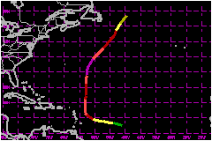
a. Synoptic HistoryThe tropical wave that spawned Gustav moved off the northwest coast of Africa on 18 August with some signs of organization. However, the system became embedded within the ITCZ on its westward journey across the tropical Atlantic and didn't gebin strengthening until late on the 23rd and early on the 24th. It is estimated that the system became Tropical Depression Eight 840 nautical miles east of Barbados near 0600 UTC on the 24th. Tropical Depression Eight gradually strengthened while moving west to west-northwestward at 12 mph and, based on satellite imagery, reached tropical storm strength 620 nautical miles east of Barbados near 0000 UTC on the 25th. Tropical Storm Gustav continued the same general motion under the influence of weak ridging to the north. There was some concern that a cold low that was located to the northwest of Gustav would inhibit development during the next day or so. However, the low had little impact and Gustav reached hurricane strength 240 nautical miles east-northeast of Barbados near 1200 UTC on the 26th. The first of 53 reconnaissance aircraft fixes in Gustav had 75-mph winds at the 1500-feet flight level with 81-mph winds estimated at the surface at 1217 UTC on the 26th. A hurricane watch was issued soon thereafter for the northern
Lesser Antilles and a prtion of that area was placed under hurricane warnings
at 2200 UTC on the 26th. However, the ridge to the north was breaking
down and Gustav began responding by taking a gradual northwestward and
then northward with the center of the system by-passing the Lesser Antilles
180 nautical miles to the east. b. Meteorological StatisticsGustav was primarily of concern to the marine community and
at least two ships reported sustained winds of hurricane force. Ship C6BB,
"Trinidad and Tobago", a merchant marine ship registered
in the Bahamas reported 75-mph winds at 0000 UTC on 27 August 210 nautical
miles northeast of Barbados. Ship FNWT, "Galion",
a vessel of French registry, appears to have gone through or near the
edge of the eye with winds of 030/81 mph at 0000 UTC on 2 September, and
280/81 mph at 1800 UTC on the same data. A pressure of 994.5 mb was reported
from the Galion at 1200 UTC on the 2nd. Very likely that ship experienced
hurricane conditions for 24 hours except for whatever period it may have
been in the eye. c. Casualty and Damage StatisticsThere were no reports of deaths or damage attributed to Gustav. The U.S. Navy Ship "Antares" was potentially threated by both Hortense and Gustav bu the U.S. Navy Tug "Apache" towed the disabled Antares to safety.
Maximum
Intensity For Hurricane Gustav
| ||||||||||||||