|
|
|
|
|||||||||||||||
|---|---|---|---|---|---|---|---|---|---|---|---|---|---|---|---|
|
1990 PRELIMINARY
REPORTS |
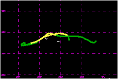
a. Synoptic HistoryEdouard began on 2 August near latitude 38°N, longitude 23°W as a wave on a cold front. Within the next 24 hours the wave developed into a strong midlatitude cyclone capped with an upper-cold low at the 200-mb level. Rapid baroclinic development over sea surface temperatures of 22°C produced a 1009-mb storm by 1200 UTC 3 August. The non-tropical storm drifted northward on 3 August and began
to weaken slightly on 4 August as it turned toward the southwest and moved
across the Azores. Heavy rains and gusty winds of 23 to 35 mph were reported
by the islands on 4 August. From 6 August through the morning of 8 August
the system made a counter-clockwise loop while located between 200 and
300 miles to the southwest of the Azores. During this time deeply organized
convection developed near the center of the circulation, and the system
was designated Tropical Depression Six at 1800 UTC 6 August. b. Meteorological StatisticsStrongest winds of 46 mph were recorded by the ship VRAZ
near 38.9°N, 24.7°W within 24 hours (1800 UTC 3 August) after
the wave began to develop on the cold front. Various reporting stations
in the Azores reported storm-force gusts on 9 August as the tropical storm
moved northeastward toward the islands. c. Casualty and Damage StatisticsThere were no casualties and damage in the Azores was minimal.
Maximum
Intensity For Tropical Storm Edouard
| ||||||||||||||