|
|
|
|
|||||||||||||||
|---|---|---|---|---|---|---|---|---|---|---|---|---|---|---|---|
|
1990 PRELIMINARY
REPORTS |
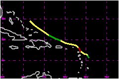
a. Synoptic HistoryKlaus originated from a tropical wave that moved off the coast of Africa on 27 September. The wave was convectively active as it moved westward across the tropical Atlantic. Evidence of a circulation was detected from METEOSAT imagery as early as the 28th when the system was located 350 nautical miles south of the Cape Verde Islands. The wave moved across the Atlantic for several days, occasionally showing signs of becoming a depression. Finally, on 3 October, when located just east of the Lesser Antilles, the wave began a steady strengthening even though there appeared to be a strong shearing environment. Klaus' best track starts with a tropical depression centered 100 nautical miles east of Dominica, at 1200 UTC on 3 October. The system drifted slowly toward the northwest for three days, caught in a weak steering current between high pressure to its east and west and with short wave troughing to the north. It quickly strengthened to a tropical storm at 1800 UTC on the 3rd and reached hurricane strength at 1200 UTC on the 5th. At this time, the center was at its point of closest approach to the Leeward Islands and was only about 25 nautical miles east of Antigua and, shortly thereafter, 10 nautical miles east of Barbuda. Tropical storm and hurricane warnings were issued as appropiate for the islands near Klaus' path. Klaus reached its peak on the 5th with 81 mph winds and a
985 millibar central pressure and was a hurricane for only 15 hours. Although
it moved close to the Leeward Islands as a hurricane, there were no observations
of sustained tropical storm force winds at Antigua or other nearby islands.
This was due to the frequent shearing conditions that caused most of the
deep convection and strong winds to be located north and east of the circulation
center. b. Meteorological StatisticsThere were 13 aircraft reconnaissance missions into Klaus with
a total of 40 center fixes during the seven day period from 3 to 9 October.
In addition, there were several investigative missions before Klaus became
a tropical cyclone. The best track peak wind of 81 mph on the 5th is
based on an aircraft measurement of 83 mph at 1500 feet. The highest
satellite based intensity estimate during this time was 63 mph. 1. Rainfall Data Grand Turk in the Bahamas reported 4.00 inches in 36 hours.
There may well have been much higher totals recorded in the Leeward Islands
since Klaus moved so slowly through this area. The remants of Klaus brought
10 to 15 inches of rain to the South Carolina midlands on the 10th and
11th of October. Ten inches of rain in the southern piedmont section of
North Carolina is also attributed to the remnants of Klaus. Georgia also
received some rain from the remnants. Details of rainfall totals in the
southeastern United Statesare contained in the Marco
preliminary report. c. Casualty and Damage Statistics
There were 4 deaths attributed to Klaus; 4 in South Carolina.
Maximum
Intensity For Hurricane Klaus
| ||||||||||||||