|
|
|
|
||||||||||||||||||||||||||||||||||||||||||||
|---|---|---|---|---|---|---|---|---|---|---|---|---|---|---|---|---|---|---|---|---|---|---|---|---|---|---|---|---|---|---|---|---|---|---|---|---|---|---|---|---|---|---|---|---|
|
2001 PRELIMINARY
REPORTS |
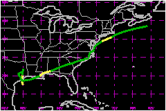
Tropical Storm Allison developed over the northwestern Gulf of Mexico and moved inland over the upper Texas coast, producing extremely heavy rainfall and catastrophic floods in the Houston area. Allison then acquired subtropical characteristics and continued to produce heavy rainfall and flooding near its track from Louisiana eastward to North Carolina, and then northward along the U.S. east coast to Massachusetts. a. Synoptic HistorySatellite images and synoptic data indicate that Allison originated from a tropical wave that moved off the west coast of Africa on 21 May. The wave tracked westward at about 17 mph across the tropical Atlantic with little associated convection before moving inland over the northern part of South America on 26 May. It emerged over the southwestern Caribbean Sea on 29 May. The wave moved westward into the eastern North Pacific Ocean on 1 June, then slowed down over the Gulf of Tehuantepec. On 2 June, the wave produced a low-level cyclonic circulation centered about 200 nautical miles south-southeast of Salina Cruz, Mexico. On 3 June, low- to mid-level southwesterly flow in the southeast quadrant of the Mexican thermal low moved the broad cyclonic circulation inland over extreme southeastern Mexico and western Guatemala. The low-level circulation weakened and became ill-defined after moving inland, whereas the strong mid-level circulation remained intact and tracked northeastward over the southern Yucatan Peninsula early on the 4th. By 0000 UTC 5 June, the mid-level circulation had moved northwestward into the Bay of Campeche of the Gulf of Mexico. Deep convection developed along the western (cyclonic-shear) side of a 35 to 46 mph low-level jet whose axis extended north-northwestward from Merida, Mexico to the Texas-Louisiana border. The deep convection persisted during the night of the 5th and eventually moved north-northwestward around an upper-level cold low centered over south Texas. The difluent eastern semicircle of the upper-level low acted to enhance the development of deep convection. By 1200 UTC on the 5th, satellite imagery and surface observations suggest that the mid-level circulation developed downward and became Tropical Storm Allison about 120 nautical miles south of Galveston, TX. The cold-core nature of the upper low detected in 0000 and 1200 UTC 5 June upper-air data suggests, however, that this system possessed some subtropical characteristics. A strong pressure gradient developed between Allison's center and the Atlantic subtropical ridge, which extended westward across Florida and the southeast U.S. and into the northeast Gulf of Mexico. Allison's central pressure dropped and sustained winds increased across a large portion of the central Gulf of Mexico. Winds as high as 46 mph, with gusts to 58 mph, occurred more than 200 nautical miles east of the center. At 1500 UTC, a ship reported a sustained wind of 49 mph with gusts to 69 mph, about 90 nautical miles east of the estimated center location. Confirmation of a closed circulation came at 1800 UTC when Buoy 42019 (located about 60 nautical miles south of Freeport, TX) reported a light northwest wind and a pressure of 1006.6 mb just west of the surface center. At 1852 UTC, aircraft personnel on the first U.S. Air Force Reserve reconnaissance flight of the day "closed off" the low-level circulation about 80 nautical miles south-southwest of Galveston, TX. A combination of a 55 kt flight-level (1500 ft) wind report and the earlier ship reports indicated that the storm had strengthened. The cyclone tracked slowly north-northwestward and weakened slightly (based on offshore buoy reports) just before making landfall southwest of Galveston near Freeport, TX. Its center then tracked slowly northward across the western portions of the Houston metropolitan area during the night of the 5th and the morning of the 6th. After moving inland, surface observations indicated that Allison quickly weakened to a tropical depression. It drifted slowly northward before becoming stationary over eastern Texas near Lufkin on 7 June. On 8 June, Tropical Depression Allison began to move slowly southward. It eventually moved back over the Gulf of Mexico around 0000 UTC on the 10th, at nearly the same location where it had made landfall as a tropical storm. Although the low-level center remained over warm water on the 10th, very dry air in the mid- and upper-levels of the troposphere overlaid the surface center. The dry air, combined with moderate upper-level westerly shear, inhibited the redevelopment of thunderstorms near the low-level center. Upper-air observations indicated that by 0000 UTC Allison had acquired some baroclinic characteristics and became a subtropical depression. Most of the persistent deep convection was then developing a couple hundred miles east of the low-level center. A new low-level circulation developed around 0000 UTC 11 June, near the strongest thunderstorms about 150 nautical miles east of the original center, approximately 50 nautical miles south of Intracoastal City, LA. By 0200 UTC 11 June, the new center moved inland over southeast Louisiana near Morgan City. During the early morning hours of the 11th, strong thunderstorms became organized near the low-level circulation center and surface observations indicated that Allison had become a subtropical storm by 0600 UTC. Convection wrapped all the way around the center creating an "eye-like" feature near 1200 UTC. In spite of the eye-like feature apparent in radar imagery, the cyclone's radius of maximum winds (~100 nautical miles) was more typical of a subtropical low. Also, surrounding upper-air observations continued to show that Allison was in a weakly baroclinic environment. The subtropical storm tracked east-northeastward across southern Mississippi. It weakened back to subtropical depression status by 0000 UTC 12 June, when the system was located over southwestern Alabama. It continued to track east-northeastward across southern Alabama, southern Georgia, and southern South Carolina before becoming stationary just north of Wilmington, NC on the 14th. The center of Allison then drifted slowly northward over eastern North Carolina and extreme southeastern Virginia on the 15th. It then moved more quickly northeastward and reached the mid-Atlantic coast on the 17th and eventually cleared the United States mainland along the Delmarva Peninsula later that day. At 1200 UTC 17 June, Allison began to interact with an approaching cold front and briefly strengthened back to a subtropical storm. Allison merged with the cold front around 0000 UTC 18 June, then becoming an extratropical low pressure system. Shortly after becoming extratropical, the system accelerated east-northeastward before dissipating southeast of Nova Scotia around 0600 UTC 19 June.
b. Meteorological Statistics Allison's peak intensity of 58 mph at 1800 UTC 5 June was
based on a 1700 UTC ship (WTEJ) observation of 55 mph and a 63 mph surface
wind estimate made by reconnaissance flight crew personnel at 1852 UTC.
1. Storm Surge DataEvacuations of the west end of Galveston Island were required due to coastal flooding since this area is not protected by the seawall that was built after the Great Hurricane of 1900. Storm surge of 2 to 3 feet, when combined with wave heights up to 8 feet, created considerable overwash. This resulted in significant beach erosion and damage to some of the island's roads. Additional storm surge of 1 to 2 feet occurred over southeast Louisiana on the 11th when Allison passed over that area as a subtropical storm.2. Rainfall DataDuring and after Allison's landfall over the upper Texas coast and its southward return to the Gulf of Mexico, extremely heavy rainfall occurred over much of eastern and southeastern Texas, including the Houston metroplex, and much of southwestern Louisiana. Several locations on the east side of Houston received more than 30 inches of rainfall. Heavy rainfall and widespread flooding also occurred with the subtropical low pressure system as it tracked across the southeast and eastern United States. 3. TornadoesA total of 23 tornadoes were confirmed from Mississippi to South Carolina from 11-16 June Specifically, 10 tornadoes were reported in South Carolina, 4 in Mississippi, 3 in Florida, 2 in both Alabama and Georgia, and 1 each in Louisiana and Virginia.
c. Casualty and Damage Statistics There were 41 deaths attributed to Allison; 23 in Texas,
8 in Florida, 7 in Pennsylvania, 1 in Louisiana, 1 in Mississippi and
1 in Virginia. Forty-one deaths are directly related to the heavy rain, flooding, tornadoes, and high surf generated by Tropical Storm Allison and its remnant subtropical circulation. Twenty-seven of these deaths were due to drowning in freshwater flooding. Early morning on the 11th in Zachary, LA, a tornado (intensity unknown) knocked down trees onto a pickup truck, killing the male driver. Later that morning, an F1 tornado cut a 4 mile long path across George County, MS. It damaged several manufactured homes and completely destroyed a mobile home (tiedowns were pulled out of the ground and the home turned over and fell apart as it rolled), severely injuring a female occupant. There were also 9 indirect deaths in North Carolina as a result of traffic accidents occurring on wet roads. These damage and direct death toll estimates make Allison the deadliest and most costly tropical or subtropical storm on record in the United States.
Maximum
Sustained Winds For Tropical Storm Allison
Minimum
Pressure For Tropical Storm Allison
Landfall
for Tropical Storm Allison
| |||||||||||||||||||||||||||||||||||||||||||