|
|
|
|
|||||||||||||||
|---|---|---|---|---|---|---|---|---|---|---|---|---|---|---|---|
|
2001 PRELIMINARY
REPORTS |
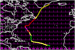
Erin was the third of a series of four "interrupted track" tropical cyclones during the 2001 Atlantic hurricane season. After re-forming, it strengthened to a category three hurricane on the Saffir-Simpson Hurricane Scale, just to the east of Bermuda. a. Synoptic HistoryErin can be traced back to a tropical wave that emerged from western Africa on 30 August. The system almost immediately showed signs of tropical cyclone formation, with curvature in the bands of associated deep convection. Dvorak classifications commenced at 1800 UTC on the 30th. There was little change in the system's organization, and deep convection was sporadic for the next day or so. On 1 September the cloud pattern began to become better organized, and based on the satellite presentation as well as drifting buoy data that showed a definite closed surface circulation, it is estimated that a tropical depression formed by 1800 UTC that day, located about 600 nautical miles west-southwest of the Cape Verde Islands. With a mid-tropospheric ridge in place to its north, the tropical cyclone moved on a west to west-northwestward heading at 16-21 mph over the following three days. At first, there was weak to moderate vertical shear over the area, and the cyclone was able to strengthen into Tropical Storm Erin by 0600 UTC 2 September. Erin's maximum winds increased to near 58 mph by 0600 UTC 3 September. Later on the 3rd, vertical shear associated with an upper-level low to the northwest caused the low-level center of the storm to become exposed to the southwest of the main area of deep convection, indicating that Erin had weakened. On the 4th, the shear appeared to lessen somewhat, and Erin re-strengthened slightly. However the system failed to become much better organized, and was soon on a weakening trend. By 5 September, southwesterly shear caused the tropical cyclone to degenerate into an area of disturbed weather. About a day later, a surface circulation re-developed in the northern part of the area of disturbed weather that was associated with Erin. The re-generated tropical depression moved north-northeastward, then north-northwestward, and regained tropical storm strength about 550 nautical miles north-northeast of the northern Leeward Islands at 1800 UTC 7 September. After a mid-level ridge to the north of Erin was temporarily weakened by a passing trough, the ridge re-built, moving the storm toward the northwest and north-northwest. Erin strengthened into a hurricane late on the 8th. While passing east of Bermuda on the 9th, Erin continued to strengthen, and it reached its peak intensity of 121 mph around 1800 UTC that day. A few hours later, the eye of the hurricane passed within about 90 nautical miles east-northeast of Bermuda, which was Erin's point of closest approach to the island. After brushing Bermuda, the hurricane continued to move mainly toward the north-northwest. On 10 September, Erin began to weaken, however the weakening was slower than usual over the ensuing days, due in part to slightly warmer than normal waters over the western subtropical Atlantic. A series of short-wave troughs weakened the western portion of the Atlantic subtropical ridge. This caused the motion of the hurricane to turn toward the right, with a decrease in forward speed, on the 11th. Erin's heading veered toward the east-northeast and east on the 12th. Then, a broad, amplifying mid- to upper-level trough over eastern Canada accelerated Erin toward the northeast. The center passed just east of Cape Race, Newfoundland at 0000 UTC, while the system was weakening to just below hurricane strength. Then, Erin lost its tropical characteristics. The extratropical storm accelerated north-northeastward and passed over southern Greenland on 16 September, and merged with high-latitude cyclonic flow over eastern Greenland on the 17th.
b. Meteorological StatisticsErin's peak intensity of 120 mph at 1800 UTC 9 September is a compromise of the following observations taken around that time: 90 percent of the maximum flight-level (700 mb) winds of 136 mph (122 mph); the surface reduction of the lowest 150 m of a dropwindsonde sounding, yielding 112 mph; and a surface value from that same sounding of 128 mph. Although the minimum central pressure value of 968 mb around the time of peak intensity would not typically support quite so high a wind speed, Erin was situated in an area of higher than average (for a tropical cyclone) environmental pressures. About 24 h after peak intensity, during 1900-2000 UTC 10 September, radar data and Stepped-Frequency Microwave Radiometer measurements from a NOAA aircraft showed that Erin had a concentric eyewall structure. Bermuda reported a peak wind gust of 41 mph at 2300 UTC 9 September, about when the center of Erin was nearest to that island. Cape Race, Newfoundland reported sustained winds of 44 mph with a gust to 53 mph at 2100 UTC 14 September, and a sustained wind of 53 mph with a gust to 67 mph at 0200 UTC 15 September. St. John's, Newfoundland reported a gust to 52 mph at 0352 UTC. Grates Cove, Newfoundland reported a gust to 64 mph at 0449 UTC 15 September, and Bonavista Newfoundland reported sustained winds of 39 mph with a gust to 67 mph at 0536 UTC 15 September. Note that the observations after 0000 UTC 15 September occurred during the extratropical stage of Erin. There were a couple of drifting buoy observations of hurricane force winds near the tropical cyclone, at 0000 and 0300 UTC 4 September, which have been excluded because they were not consistent with nearby observations in time and/or space (the best track intensity was 46-52 mph around these times). 1. Rainfall DataMaximum rainfall totals from Newfoundland were 131 mm (5.1 in) at Sagona Island, 102 mm (4.0 in) at Burgeo, and 78 mm (3.1 in) at Bonavista.
c. Casualty and Damage StatisticsThere were no reports of damage or casualties associated with Erin.
Maximum
Intensity For Hurricane Erin
| ||||||||||||||