|
|
|
|
|||||||||||||||||||||||||
|---|---|---|---|---|---|---|---|---|---|---|---|---|---|---|---|---|---|---|---|---|---|---|---|---|---|
|
2001 PRELIMINARY
REPORTS |
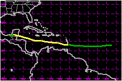
Poorly-organized for most of its life cycle, Chantal was a tropical storm that made landfall near the Mexico-Belize border. Development was hindered by a strong low- to mid-level easterly flow that contributed to a rapid translation speed and persistent westerly shear. a. Synoptic HistoryChantal developed from a tropical wave that crossed the coast of Africa and entered the far eastern Atlantic on 11 August. Although convection diminished after the system left the African continent, a broad surface low and a closed circulation developed by the 13th. Early on the 14th, convection increased northwest of the center. By 1800 UTC on the 14th, when the system was about 1300 nautical miles east of the southern Windward Islands, the convection was sufficiently well-established and organized to consider the low to be a tropical depression. A QuikSCAT pass near this time (at 2000 UTC), indicated a broad closed cyclonic surface circulation. South of a strong mid-level ridge, the depression moved rapidly westward at about 26 mph. The convective structure changed little for the next 36 hours under easterly wind shear, but banding developed early on the 16th. Even though the satellite presentation continued to improve throughout the day, reconnaissance aircraft data near 2100 UTC could not define a closed circulation. It is impossible to determine precisely when the depression's surface circulation degenerated into an open wave, but a QuikSCAT pass suggests that this may have occurred near 1200 UTC on the 16th, when the consensus of Dvorak intensity estimates reached tropical storm strength. At this time the system's forward speed was increasing to near 35 mph. Early on the 17th, the wave sped through the Windward Islands, where there was a report of sustained tropical storm force winds from Martinique. After passing through the islands, the wave's speed slowed to about 23 mph and its convective pattern, which had been limited and linear, expanded and became more symmetric. At 1400 UTC, a reconnaissance aircraft was able to determine that a small closed circulation had redeveloped about 250 nautical miles south of St. Croix; with winds still near 40 mph, the wave had become a tropical storm. Over the next 18 h the pressure fell from 1010 mb to 1003 mb and Chantal's maximum winds increased to 63 mph. During the morning of the 18th, however, Chantal weakened slightly as its forward speed increased again (to 28 mph) and its low-level center raced ahead of the deep convection. This was followed by a second episode of slowing and strengthening that ended at 0600 UTC on the 19th, when the pressure fell to 997 mb and the winds increased to 69 mph. At this time Chantal was moving westward at 12 kt about 160 nautical miles south of Kingston, Jamaica. It is possible that the apparent reduction in forward speed was a result of a reorganization or reformation of the low-level circulation. During the day on the 19th, Chantal again became disorganized with an ill-defined center located well to the west-southwest of the main area of deep convection. Although the pressure rose sharply, to 1008 mb, reconnaissance aircraft continued to report strong winds in the trailing convection. Chantal turned slightly to a west-northwesterly heading, and maintained a near steady state structure in the northwestern Caribbean Sea with 58 mph winds until late on the 20th. (During this time, there were large differences, often 60 nautical miles or more, between aircraft- and satellite-based position fixes. Since the wind centers found by the aircraft were probably not representative of the vorticity center of the system, the best track through this period is based primarily on the satellite data.) When Chantal approached Belize and the Yucatan Peninsula late on the 20th, the storm became much better organized. Reconnaissance aircraft, which had for days had difficulty closing off the circulation on the cyclone's south side, found a well-defined center for the first time, with the strongest winds closer to the center than was observed previously. Water vapor imagery indicated that the upper-level westerly vertical wind shear was decreasing, and the cyclone's forward speed again decreased, from 17 to 12 mph. That these latter two events would occur simultaneously suggests that a reduction in the low-level easterly flow also contributed to this final period of development. The pressure dropped steadily in the final hours before landfall, reaching an estimated 999 mb when the center came ashore near the Belize/Mexico border around 0200 UTC on the 21st. The maximum winds at landfall are estimated to be 69 mph. As Chantal made landfall its forward speed continued to slow, and radar imagery from Belize showed that the system's organization continued to improve for several hours as it slowly moved inland. Had Chantal remained over water for another hour or two, it is quite likely that it would have become a hurricane. Over the next day and a half Chantal moved westward and then southwestward over the Yucatan and southeastern Mexico, weakening to a depression on the 22nd at 0000 UTC, and dissipating by 1800 UTC that day.
b. Meteorological StatisticsChantal's maximum intensity of 69 mph was attained on two occasions. In the first instance, the peak flight-level wind from reconnaissance aircraft in Chantal was 94 mph, measured at a flight level of 850 mb at 1123 UTC on the 19th. While the standard reduction for this altitude would indicate that Chantal was a hurricane with a surface equivalent of 76 mph, several factors suggest that this was not the case. First, the area of flight-level winds that supported hurricane intensity were extremely limited, and therefore may not have been representative of the cyclone's circulation. Second, Chantal's minimum pressure was rising rapidly at the time of the observation; this is consistent with the view that the peak wind observed by the aircraft was primarily a local convective, rather than a cyclone-scale event. The most convincing evidence, however, comes from soundings in the storm core and environment in the right semicircle, which show significant shear in the lower troposphere. The Kingston sounding from 1200 UTC on the 18th, for example, shows about 23 mph of easterly shear between 925 and 700 mb. A dropwindsonde at 2340 UTC 19 August, which reported 700 mb winds of 69 mph, had a surface wind of only 44 mph. In this environment, a lower than normal surface wind reduction would be appropriate on the right-hand side of the cyclone. Chantal also reached an intensity of 69 mph just prior to landfall. This estimate is supported by a surface wind of 67 mph from a GPS dropwindsonde, and a surface-adjusted flight-level wind of 66 mph. Numerous dropsonde profiles from Air Force and NOAA aircraft just before landfall indicate that the surface adjustment factors had returned to more typical values. The estimated landfall pressure of 999 mb is based largely on an extrapolation of the deepening trend observed by reconnaissance aircraft up until the last report at 2307 UTC on the 20th. In the Lesser Antilles, the automated site on Martinique (78922, station elevation 33 m) reported a 10-min sustained wind of 39 mph at 0600 UTC on the 17th. Based on aircraft and dropsonde reports, the strongest winds at landfall in the western Caribbean were likely in a band roughly 30-40 nautical miles north of the center, near Chinchorro Banco. Unfortunately, there are no observing stations in this area. Caye Caulker, Belize reported a gust of 71 mph, and Chetumal, Mexico reported a gust of 62 mph. 1. Rainfall DataChantal produced copious amounts of rain. The largest storm total (13.41 in) was reported from Chetumal. Several sites in Belize reported totals in the 8-10 in range.
c. Casualty and Damage Statistics There were 2 deaths attributed to Chantal; 2 in Trinidad.
In Belize, damage estimates are near $4 Million, primarily from wave damage to sea-walls and piers, agricultural losses from wind and floods, and erosion of roads due to floods. About 8000 persons were evacuated, mainly from offshore islands. About 2500 persons were evacuated from vulnerable areas in Mexico. Reports from Mexico indicate downed trees but otherwise no significant damage.
Maximum
Intensity For Tropical Storm Chantal
Landfall
for Tropical Storm Chantal
| ||||||||||||||||||||||||