|
|
|
|
|||||||||||||||
|---|---|---|---|---|---|---|---|---|---|---|---|---|---|---|---|
|
2001 PRELIMINARY
REPORTS |
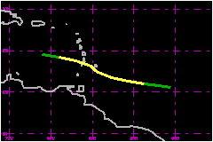
Jerry was a poorly-organized, short-lived tropical storm that passed through the Windward Islands with minimal impact. a. Synoptic HistoryA westward-moving tropical wave crossed the west coast of Africa and entered the tropical Atlantic on 1 October. The wave's cloud pattern changed little in organization until 4 October, when the associated deep convection increased and exhibited some curved banding in the vicinity of 40W longitude. The system did not become significantly better organized for a couple more days, as it continued westward. On 6 October, the deep cloudiness become more concentrated and it is estimated that a tropical depression, Twelve, formed by 1200 UTC that day, about 540 nautical miles east-southeast of Barbados. A ridge of high pressure in the lower- to mid-troposphere steered the tropical cyclone on a heading slightly north of west at 17-23 mph. There was fairly weak vertical shear over the system, and the depression strengthened into Tropical Storm Jerry around 0000 UTC 7 October. Jerry's sustained winds increased to their maximum speed, estimated near 52 mph, as the storm approached the Windward Islands on 7 October. A little later that day, the center of the tropical cyclone passed a short distance south of Barbados. As it moved through the Windward Islands around 0000 UTC 8 October, Jerry apparently made a jog to the northwest and temporarily decreased its forward speed. There may also have been a northward re-formation of the center; aircraft data showed evidence of multiple low-level centers along a northeast-southwest axis around that time. After passing near St. Vincent around 0300 UTC on the 8th,
Jerry moved into the eastern Caribbean Sea, its forward speed increasing
to near 23 mph. Moderate northwesterly shear was disrupting the upper-level
outflow, and the system lacked a single, well-defined center of circulation.
Later on the 8th, Jerry's organization deteriorated further
while the system was moving rapidly westward about 200 nautical miles
south of Puerto Rico. The tropical cyclone then dissipated.
b. Meteorological StatisticsAn automated station, Caravelle (number 78922, station elevation 33 m), at Martinique reported a sustained (10 minute average) wind of 45 mph with gusts to 58 mph around 0600 UTC 8 October. There were no ship reports of tropical storm force winds associated with Jerry. A ship with call sign FNOR reported a wind of 110/38 mph at 15.3N 60.9W at 0600 UTC 8 October. Barbados reported a minimum pressure of 1007 mb at 1900 and 2000 UTC 7 October.
c. Casualty and Damage StatisticsThere were no reports of damages or casualties associated with Jerry.
Maximum Intensity For Tropical Storm Jerry
| ||||||||||||||