|
|
|
|
|||||||||||||||||||||||||||||||||||||||
|---|---|---|---|---|---|---|---|---|---|---|---|---|---|---|---|---|---|---|---|---|---|---|---|---|---|---|---|---|---|---|---|---|---|---|---|---|---|---|---|
|
2001 PRELIMINARY
REPORTS |
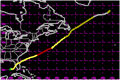
Gabrielle made landfall on the Florida west coast as a tropical storm with 69-mph sustained winds and then became a category one hurricane (on the Saffir-Simpson Hurricane Scale) as it moved across the northwest Atlantic Ocean. It produced major river floods over west-central Florida and at the lower St. Johns River and also caused heavy rain over southeastern Newfoundland. a. Synoptic HistoryGabrielle's origin was non-tropical. On 5 September, a weak low- to mid-level trough, and its associated cloudiness and showers, was nearly stationary and located just east of the southeastern U.S. coast. This feature persisted and gradually resulted in a low- to mid-level cut-off low over Florida by the 9th. Late on the 11th, a surface low formed over the southeastern Gulf of Mexico in association with the cut-off low and convection was sufficiently well-organized to classify the system as Tropical Depression Eight. The "best track"of the tropical cyclone begins at 1800 UTC on the 11th. Under weak steering currents, the cyclone moved in a small counterclockwise loop over the southeastern Gulf of Mexico for two and one-half days and gradually strengthened. It reached tropical storm strength mid-day on the 13th while located about 175 nautical miles southwest of Venice, Florida. By this time, a mid-level trough in the westerlies was moving into the eastern United States and Gabrielle began moving northeastward with increasing forward speed. Gabrielle's center made landfall on Florida's west coast near Venice at about 1200 UTC on the 14th. The storm strengthened to 69 mph just before landfall, even though a SHIPS analysis, based on the Aviation model, calculated about 29 mph of westerly vertical shear affecting the storm at this time. The storm decelerated and its winds decreased to 46 mph during the center's 18-hour traverse across central Florida. The center moved offshore on the Florida east coast near Titusville and accelerated northeastward. Although the cyclone was highly sheared, winds strengthened to 81 mph on the 17th while it was located about 200 nautical miles northwest of Bermuda. Continuing northeastward, Gabrielle weakened to 69 mph and, at 0600 UTC on the 19th, lost all deep convection near the center while located about 300 nautical miles south of Newfoundland. Gabrielle is assigned extratropical status at this time. Still moving northeastward, Gabrielle passed near southeastern Newfoundland and merged with another extratropical low on the 21st over the far north Atlantic Ocean.
b. Meteorological StatisticsOn the 14th, when Gabrielle was nearing the west coast of Florida, aircraft 700-millibar flight-level winds suggest that surface winds were near 75 mph. But the Venice C-MAN station, almost beneath the location of the aircraft strong winds, reported a maximum surface wind of 58 mph. At nearby New Pass, the highest measured surface wind was 59 mph and this was a 15-minute average. The aircraft reported a dropsonde central pressure of 980 mb at 1009 UTC and 983 mb at 1132 UTC. The aircraft weather officer also reported a 972-mb value extrapolated from flight level at 0850 UTC and associated with a temperature spike. The best-track wind speed of 69 mph at 1200 UTC is a compromise between these observations and represents an estimate of the strongest sustained winds that occurred on the southwest Florida coast. There is an uncertainty associated with official surface wind speed estimates and it is possible that Gabrielle was briefly a hurricane while making landfall. Inland winds ranged from 40-52 mph as the storm moved northeastward across Florida. The strengthening to 81 mph on the 17th is based on aircraft dropsonde and flight-level wind speeds. The maximum flight-level wind speed was 98 mph at 850 mb at about 1700 UTC. The standard reduction to the surface under deep convection is 90 percent, which yields a 89-mph surface wind. A few hours earlier, a GPS-dropsonde indicated a surface wind speed of 69 mph.
The rain over west-central Florida resulted in major floods on the Manatee
River, Little Manatee River, Myakka River, Peace River, and Horse Creek.
A river gage at Arcadia on Horse Creek reported a crest of 16.8 feet. Flood
stage for this location is 12 feet. Minor river and urban flooding occurred
elsewhere along the path of the storm across Florida. | ||||||||||||||||||||||||||||||||||||||
| Date/Time (UTC) |
Position | Pressure (mb) |
Wind Speed (mph) |
Stage | |
|---|---|---|---|---|---|
| Lat. (°N) | Lon. (°W) | ||||
| 17/1200 | 35.3 | 66.6 | 983 | 80 | Category 1 Hurricane |
Minimum
Pressure For Hurricane Gabrielle
11 - 21 September, 2001
| Date/Time (UTC) |
Position | Pressure (mb) |
Wind Speed (mph) |
Stage | |
|---|---|---|---|---|---|
| Lat. (°N) | Lon. (°W) | ||||
| 19/0000 | 41.5 | 57.5 | 975 | 70 | Tropical Storm |
Landfall
for Hurricane Gabrielle
11 - 21 September, 2001
| Date/Time (UTC) |
Pressure (mb) |
Wind Speed (mph) |
Stage | Landfall |
|---|---|---|---|---|
| 14/1200 | 983 | 70 | Tropical Storm | Venice, Florida |