|
|
|
|
|||||||||||||||
|---|---|---|---|---|---|---|---|---|---|---|---|---|---|---|---|
|
2001 PRELIMINARY
REPORTS |
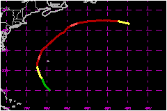
Humberto was a category 2 hurricane (on the Saffir-Simpson Hurricane Scale) that passed about 120 nautical miles to the west of Bermuda. a. Synoptic HistoryHumberto had its origin in a trough of low pressure that extended southwestward from the circulation of Hurricane Gabrielle. On 18 September, a westward-moving upper-level low passed over the surface trough about 600 nautical miles south-southeast of Bermuda and enhanced deep convection there. A weak low formed in this area the following day and began to drift westward. The system gradually became better organized, and Dvorak classifications were initiated early on 20 September. The system became Tropical Depression Ten near 1200 UTC 21 September, when deep convection developed near the center of a broad cyclonic circulation defined by low-cloud vectors in the satellite imagery, about 425 nautical miles south of Bermuda. Moving to the northwest at about 9 mph, the depression's surface circulation remained weak and disorganized on 21 September despite a rapidly improving and impressive appearance in satellite imagery. Surface development appeared to catch up to the satellite signature the next day, however, and the depression is estimated to have reached tropical storm strength by 1200 UTC 22 September, about 275 nautical miles south-southwest of Bermuda. Moving around the periphery of the subtropical ridge, Humberto turned to the north-northwest and gradually strengthened, becoming a hurricane at 1200 UTC 23 September, about 150 nautical miles west-southwest of Bermuda. Humberto then turned to the north-northeast and reached its first peak in intensity, 98 mph and 983 mb, shortly thereafter at 0000 UTC 24 September. Strong upper-level westerlies began to shear the system, and within 12 h the estimated maximum surface winds in Humberto had fallen to 81 mph. However, once Humberto passed north of the subtropical ridge, it turned to the northeast and accelerated within a more vertically uniform steering current and the weakening trend slowed. With a large mid- to upper-level cutoff low over the Midwestern states, downstream ridging caused Humberto to slow on 25 September. An eye was then apparent intermittently on satellite images. Humberto moved underneath the downstream ridge and turned briefly northward early the next day. At this point the eye became much better defined and Humberto quickly strengthened over water temperatures no higher than 25-26C, reaching its peak intensity of 104 mph and 970 mb at 1200 UTC 26 September, about 175 nautical miles south-southeast of Sable Island. The ridging that had been sheltering Humberto quickly collapsed and upper-level westerly flow again impinged on the cyclone. Humberto turned northeastward again and began to accelerate over colder waters, weakening rapidly. Moving eastward at 32 mph, Humberto weakened to a tropical storm at 1200 UTC 27 September about 350 nautical miles southeast of Cape Race Newfoundland. As Humberto was beginning to lose its tropical characteristics, its cloud pattern becoming distorted and separated from the low-level wind center, the cyclone dissipated when its weakening circulation degenerated into an open trough shortly after 1800 UTC 27 September.
b. Meteorological StatisticsThe first reconnaissance mission in the depression near 1800 UTC 21 September was not able to formally close off the center; however, the data did suggest that a small circulation was present. Subsequent reconnaissance missions indicated that Humberto's circulation remained small. When the reconnaissance aircraft entered then-Tropical Depression Ten near 1800 UTC 22 September, they found a peak flight-level (1500 ft) wind of 66 mph (estimated surface-equivalent of 53 mph), and visually estimated the surface winds to be 63-69 mph. It is therefore assumed that Humberto had reached tropical storm strength by 1200 UTC that day. The first peak intensity of 98 mph at 0000 UTC 24 September is based in part on a dropwindsonde spot surface report of 100 mph. While surface winds derived from dropsonde layer averages are lower, suggesting that this surface value may not have been representative, the surface report is consistent with data from the Stepped Frequency Microwave Radiometer (SFMR) on board the NOAA WP-3D research aircraft. Humberto's peak intensity of 104 mph on 26 September is based on Dvorak satellite classifications from TAFB and SAB. Bermuda experienced a maximum sustained wind of 28 mph, with gusts to 43 mph, when Humberto passed 120 nautical miles to the west of the island.
1. Rainfall DataBermuda also reported a storm total rainfall of 1.69 inches.
c. Casualty and Damage StatisticsThere were no reports of damage or casualties associated with Humberto.
Maximum
Intensity For Hurricane Humberto
| ||||||||||||||