|
|
|
|
|||||||||||||||||||||||||
|---|---|---|---|---|---|---|---|---|---|---|---|---|---|---|---|---|---|---|---|---|---|---|---|---|---|
|
2001 PRELIMINARY
REPORTS |
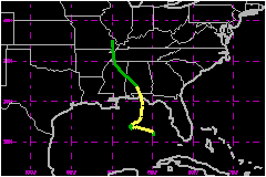
Barry was a strong tropical storm that caused minor damage in the western Florida Panhandle. a. Synoptic HistoryBarry formed from a tropical wave that moved westward from the coast of Africa on 24 July. The wave moved westward across the tropical Atlantic with little development until the 28th, when convection started increasing just east of the Lesser Antilles. The system moved into the eastern Caribbean Sea on 29 July accompanied by poorly organized thunderstorms and gusty winds. Convection continued increasing on 30-31 July as the wave moved west-northwestward through the Caribbean. It moved into the southeastern Gulf of Mexico on 1 August, accompanied by widespread heavy rains over southern Florida and western Cuba. A broad 1014 mb low formed along the wave near Dry Tortugas, Florida late on 1 August. The low moved northwestward and intensified. An Air Force Reserve Hurricane Hunter aircraft reached the center at 1829 UTC 2 August and found that the system had become Tropical Storm Barry. A large area of tropical storm winds existed north and east of the center, primarily due to interaction with a strong surface ridge. Post-analysis suggests that the low had become a tropical depression about 6 h earlier approximately 175 nautical miles west-northwest of Key West, Florida. Barry may not have been fully tropical when it formed, because an upper level low was over the surface center. However, southwesterly upper level flow moved the upper low moved northeastward while Barry moved west-northwestward due to the ridge over the United States. This shear, combined with falling external surface pressures as the ridge weakened, caused it to weaken to a depression early on 4 August. Barry then remained in a generally unfavorable environment until early on the 5th. The weakening ridge caused the steering currents to collapse, and Barry slowed to a west-southwestward drift on the 3rd. This was followed by a general northeastward drift on the 4th. Flow around a mid/upper level low dropping southward into the western Gulf states caused Barry to turn northward and accelerate on 5 August. Concentrated convection formed near the center early that day and this led to another significant burst of intensification. The central pressure fell from 1004 mb to 990 mb in 7 h as the organization of the system improved dramatically in satellite and radar imagery. Although the strengthening was short-lived, it made Barry a 69 mph cyclone. This intensity was maintained through landfall near Santa Rosa Beach, FL at 0500 UTC 6 August. The cyclone turned northwestward and weakened rapidly after landfall. It became a tropical depression over southern Alabama later on the 6th and further weakened to a low pressure area near Memphis, TN the next day. The remnant low dissipated over southeastern Missouri on the 8th.
b. Meteorological StatisticsThe Air Force Reserve Hurricane Hunters made 35 center "fixes" during Barry. The maximum flight level winds reported by the aircraft were 82 mph just after the center made landfall. Additionally, an eyewall dropsonde measured 70 mph surface winds at 1847 UTC on the 5th. The maximum surface winds reported by an official land station were 48 mph with gusts to 79 mph at station C-72 of the Eglin AFB mesonet. Shortly after landfall, an unofficial observation from Seagrove Beach, FL reported a 3-minute average wind of 94 mph with gusts to 107 mph. This and the 82 mph flight-level wind suggested the possibility that Barry had reached hurricane strength just as it was making landfall. No official observations supported the Seagrove Beach data, so several efforts were made to verify its validity: First, personnel from the NWS Forecast Office in Mobile, AL investigated the Seagrove Beach report. They indicate that the wind damage in the area was far less than what would be expected for the reported winds. This casts some doubt as to the accuracy of the data. Second, additional analysis was conducted by the Hurricane Research Division using the HWIND system on the aircraft and surface data. The analysis yielded a maximum sustained wind at landfall of 71 mph. Third, the WSR-88D radar at Eglin Air Force Base indicated hurricane-force winds about 1500 ft above the surface as Barry approached the coast. Unfortunately, the radar failed about an hour before landfall, and it is unknown how these winds evolved as the center reached the coast. The National Hurricane Center (NHC) conducted post-analysis of the radar wind data using some experimental algorithms. This was inconclusive as to whether the hurricane-force winds aloft reached the surface. Fourth, the NHC sent a request to the public asking for additional observations from the landfall area.Several of the wind reports were in the 69-75 mph range with higher gusts, which supports Barry being right on the threshold of a hurricane. However, the quality of this data is uncertain due to the mostly unknown accuracy and exposure of the instruments. The lowest aircraft-measured pressure was 990 mb at 1154 UTC 5 August and again at landfall. The lowest pressure from an official station was 994.2 mb from the Eglin AFB mesonet. The supplemental data included a 988.5 mb pressure in Freeport, FL, which was likely in the eastern side of the eye. While this and a 989.1 mb observation in Destin were slightly lower than the landfall pressure reported by aircraft, the accuracy of these supplemental measurements is unknown. Therefore, the best track landfall pressure will be the 990 mb reported by the aircraft. Most of the much-appreciated supplemental wind and pressure data are consistent with the wind and pressure values the NHC determined from reconnaissance data. However, due to the uncertainties in the data quality, the data are not quite enough to justify calling Barry a hurricane at landfall. The core of Barry missed most ships and buoys. The most significant
marine observation was from buoy 42039, which reported 45 mph sustained
winds with gusts to 62 mph and a 1001.5 mb pressure at 2000 UTC 5 August.
An unidentified ship reported 30 kt winds with gusts to 58 mph over the
southeastern Gulf from 0200-1000 UTC 2 August. This, combined with data
from the Coastal Marine Automated Network Station at the Dry Tortugas,
provided evidence that the tropical wave was developing into a tropical
cyclone. 1. Storm Surge DataStorm surges and tides associated with Barry were 2-3 ft near the landfall area in Bay and Walton counties. Tides of 2-3 ft above normal also occurred along portions of the southeast Louisiana coast in association with the strong winds early in Barry's life. 2. Rainfall DataStorm total rainfalls were generally 5-9 inches over the Florida Panhandle near and east of where the center made landfall with 1-4 inches elsewhere in the affected area from southwestern Georgia to northern Mississippi. The maximum amount from an official station was 8.91 inches at Tallahassee, FL. Supplemental observations included 11.00 inches at WJHG-TV in Panama City, FL and 9.57 inches at Port St. Joe, Fl. These rains caused localized flooding. The pre-Barry tropical wave produced 3 to 8 inches of rain over portions of southern Florida with local amounts as high as 13 inches in Martin County. These rains helped relieve long-term drought conditions in south Florida. 3. TornadoesOne tornado has been confirmed in association with Barry - an F0 near Carrabelle, FL. The pre-Barry wave produced F0 tornadoes near Ft. Pierce and Boynton Beach, FL. All three tornadoes caused minor damage.
c. Casualty and Damage Statistics There were 2 deaths attributed to Barry; 2 in Florida. The American Insurance Services Group estimates insured property damage from Barry to be $15 Million. Applying a 2:1 ratio of total damage to insured damage, the total damage from Barry is estimated to be $30 Million.
Maximum Sustained Winds For Tropical
Storm Barry
Landfall
for Tropical Storm Barry
| ||||||||||||||||||||||||