|
|
|
|
|||||||||||||||||||||||||
|---|---|---|---|---|---|---|---|---|---|---|---|---|---|---|---|---|---|---|---|---|---|---|---|---|---|
|
2001 PRELIMINARY
REPORTS |
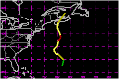
Karen was a category 1 hurricane that originated from a baroclinic system. The cyclone passed just south of Bermuda as a powerful extratropical low and subtropical storm, and produced hurricane force wind gusts and widespread damage on the island. Karen later made landfall on Nova Scotia as a weak tropical storm. a. Synoptic HistoryKaren originated from a cold frontal system that stalled a couple hundred miles southeast of Bermuda on 10 October. During the day, a strong negatively-tilted, difluent upper-level trough dug sharply southeastward off the east coast of the United States. The associated strong divergence and upward vertical motion fields east of the trough interacted with the cold front, increased the baroclinic characteristics of the boundary, and helped spin up a deep, extratropical low pressure system about 300 nautical miles southeast of Bermuda. Due to the strong baroclinic effects, the occluded low pressure system continued to deepen and tracked northward at 23 mph. By 1800 UTC 11 October, the mid- to upper-level circulations became vertically aligned with the low-level center as the system slowed down and tracked northwestward at 15 to 17 mph. An upper-air observation at 2300 UTC from Bermuda indicated the presence of potentially cold, dry air in the mid- to upper-levels, which is not typical of the inner-core region of a tropical cyclone. However, the sounding data also showed that the powerful low pressure area was beginning to acquire some warm-core characteristics. The low- to mid-levels had become warmer than the surrounding environment (compared to the 1100 UTC sounding; data not shown) and the lapse rate was saturation adiabatic up to about 500 mb. The vertical wind profile was also more characteristic of a warm-core cyclone with the strongest winds occurring near the top of the boundary layer with decreasing wind speeds above that. By 0000 UTC 12 October, the system had strengthened into an powerful 988 mb low and became Subtropical Storm One about 30 nautical miles south of Bermuda. The cyclone continued to acquire more tropical characteristics -- strong thunderstorms near the low-level center by around 1800 UTC. At that time, the low had also become cut off from the polar westerlies and had turned northward with a marked decrease in forward speed. The occluded frontal appearance in satellite imagery also became less distinct, which further indicated that the system was undergoing a transition from an subtropical low to a tropical cyclone. An investigative flight by an Air Force Reserve reconnaissance aircraft near that time confirmed that the cyclone had warm-core characteristics, at least in the lower levels of the troposphere where the entire mission took place. Deep convection continued to develop and eventually encircled the low-level center giving the appearance of a banded-eye feature in satellite imagery. At 0600 UTC 13 October, Advanced Microwave Sounding Unit (AMSU) satellite-derived temperature data indicated the system had acquired enough warm-core characteristics throughout the vertical column to make the transition to a tropical cyclone and it became Tropical Storm Karen about 170 nautical miles north of Bermuda. Karen then intensified very slowly and became a hurricane at 1800 UTC based on Dvorak satellite intensity estimates. Karen moved in a general northward direction for the next two
days and reached a peak intensity of 81 mph at 0600 UTC 14 October when
it was located about 350 nautical miles south of Halifax, Nova Scotia.
After peaking, Karen slowly weakened until the cyclone reached the southwest
coast of Nova Scotia near Western Head as a 46-mph tropical storm at around
1200 UTC on the 15th. The cyclone then made a sharp turn to
the northeast under the influence of strong mid-latitude westerlies and
became an extratropical low pressure system again, losing all of its deep
convection. The remnant low-level circulation eventually became absorbed
by a larger extratropical low pressure system located to the west of Newfoundland
over the Gulf of St. Lawrence.
b. Meteorological StatisticsSustained winds to near hurricane strength with wind gusts ranging from 90 to 98 mph were officially reported on Bermuda. A gust to 118 mph was reported by the cruise ship Nordic Empress anchored in a harbor on the west side of Bermuda at around 2317 UTC 11 October, when the low was near its closest approach to the island. An Air Force Reserve reconnaissance aircraft made an investigative flight into Karen from 1600 UTC to 2100 UTC 12 October. The two center penetrations at 1725 UTC and 1910 UTC indicated 850 mb flight-level winds of 61 mph and 77 mph, respectively, which only equates to surface winds of approximately 48 mph and 62 mph, respectively, when using the standard 0.80 reduction factor. However, two dropwindsondes released northwest and southeast of the center indicated wind speeds of 69 to 72 mph in the boundary layer with a sharp decrease to less than 52 mph near the surface. Karen's peak intensity of 81 mph at 0600 UTC 14 October is based on an objective Dvorak satellite intensity estimate (ODT) of 81 mph. It is important to note some of the inner-core thermodynamic and kinematic characteristics of Karen when the system passed close to Bermuda as an extratropical low. The 2300 UTC 11 October upper-air sounding indicates a vertical wind profile more characteristic of a warm- core tropical cyclone with the strongest winds (81 mph) present in the lowest layers with weakening and veering winds in the mid- and upper-levels. Temperatures at 700, 500, 400, and 300 mb also warmed 7.0O , 7.0O, 6.2O, and 4.2O C, respectively, during the previous 24 h, whereas temperatures at 250 and 200 mb remained steady or cooled slightly during the same period. While the vertical temperature and moisture profiles revealed a moist warm-core up to about 500 mb, this layer was overlaid by a deep layer of potentially colder and drier air. In fact, the lapse rate in the mid- and upper-levels were sharply cooler than the typical saturation adiabatic lapse rate of the inner-core region of tropical cyclones. This was most pronounced in the 500-400 mb layer where the lapse rate steepened to nearly dry adiabatic. While the sounding data indicates a thermodynamic structure more typical of a cold core, extratropical low pressure system above 500 mb, the vertical wind profile more closely resembles that of a warm-core tropical cyclone. Hence, the system is classified as a subtropical storm immediately after the sounding time. However, there is presently no definitive criteria for determining when an extratropical low acquires enough warm-core characteristics to be classified as a subtropical low or when a subtropical low becomes a tropical cyclone. It is entirely possible that at 2300 UTC 11 October, Karen was already near tropical cyclone status. Concerning the near-hurricane force sustained winds observed on Bermuda, the strong pressure difference between the central pressure (988 mb) and the higher than normal surrounding environmental pressures (1016-1020 mb) likely created a very tight pressure gradient across the island. While the Bermuda upper-air vertical wind profile did not indicate any winds greater than 81 mph, the 118 mph wind gust observed by the Nordic Empress could have been caused by strong convective downdrafts emanating from low-topped convection. The downdrafts could have been created by the entrainment of the potentially cold (290-295 K theta-e) dry air that was present in the 400-300 mb layer.
c. Casualty and Damage Statistics There were no deaths associated with Karen. Some beneficial rainfall of 1.4 to 1.8 inches occurred across portions of drought-stricken Nova Scotia and New Brunswick. However, owing to the rapid forward speed and weakening trend at landfall, most areas of Nova Scotia, New Brunswick, and Prince Edward Island generally received less than one-half inch of rainfall. Wind gusts as high as 64 mph only caused minor tree damage on Nova Scotia. There were no reports of casualties.
Maximum Intensity For Hurricane Karen
Landfall
for Hurricane Karen
| ||||||||||||||||||||||||