|
|
|
|
|||||||||||||||
|---|---|---|---|---|---|---|---|---|---|---|---|---|---|---|---|
|
2001 PRELIMINARY
REPORTS |
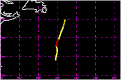
Hurricane Noel was a short-lived hurricane of subtropical origin. a. Synoptic HistoryNoel developed from a non-tropical occluded low that gradually lost its frontal structure. The first appearance of the frontal low in surface synoptic maps was at 0000 UTC 2 November, when a 1002-mb low was analyzed near 32N, 42W. The low deepened and occluded while it moved slowly west-northwestward over the next 48 h. The official "best track" of Noel begins at 0000 UTC 4 November when the system, then 775 nautical miles south of Cape Race, Newfoundland, was being classified as a subtropical cyclone by both the Tropical Analysis and Forecast Branch (TAFB) and the Satellite Analysis Branch (SAB). The subtropical cyclone drifted northward initially, its speed
increasing to about 12 mph by late on 4 November. Convection, which had
been limited to the northern semicircle, became more symmetric as it formed
a ring around the center with a radius of about 60 nautical miles. The
system developed a weak mid-level warm core early on 5 November, strengthened
and became a hurricane with 75 mph winds at 1200 UTC that day, about 535
nautical miles south-southeast of Cape Race. By 0000 UTC 6 November, westerly
wind shear began to displace and limit convection near the center, and
Noel weakened to a tropical storm. Noel then accelerated to the north,
and had lost all its convection by 1200 UTC that day, when it became extratropical
about 285 nautical miles southeast of Cape Race. The extratropical low
was absorbed into a larger extratropical system later that day.
b. Meteorological StatisticsInitial subtropical classifications of 52-58 mph are consistent with a QuikSCAT pass near 0800 UTC 4 November showing peak winds of 52 mph. Although satellite intensity estimates remained constant over the next 30 h, a report from the ship Tellus (call sign WRYG) of 75 mph at 1400 UTC 5 November indicates the system had strengthened. This ship report is the basis for the peak intensity estimate of 75 mph. Microwave sounding data suggested that a weak warm core near 550 mb had developed by about 1000 UTC on the 5th.
c. Casualty and Damage StatisticsThere were no reports of damage or casualties associated with Noel.
Maximum Intensity For Hurricane Noel
| ||||||||||||||