|
|
|
|
|||||||||||||||
|---|---|---|---|---|---|---|---|---|---|---|---|---|---|---|---|
|
2002 PRELIMINARY
REPORTS |
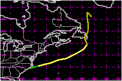
Arthur was a tropical storm, with wind speeds up to 58 mph, that moved east-northeastward across the western North Atlantic Ocean. a. Synoptic HistoryThe origin of Arthur was a weak low-level circulation first detected in the eastern Gulf of Mexico on July 9th. This system was likely associated with a decaying frontal zone that had persisted in the area for several days. The circulation and associated low pressure meandered for a few days, then accelerated northeastward across the southeastern U.S. on the 13th. This was in response to a mid-level trough amplifying southward along the U.S. east coast. The circulation moved along the coast of South and North Carolina on the 14th. By 1800 UTC of the 14th, the circulation and its associated convection were well enough organized to become Tropical Depression One, centered about 40 nautical miles west-southwest of Hatteras, North Carolina. The "best track" of the tropical cyclone's path begins on the 14th.. A mid-level low cut off from the westerlies and deepened as
it dropped southward over the Canadian Maritimes. The depression responded
by accelerating east-northeastward and slowly strengthening. It became
a tropical storm on the 15th when its winds increased to 40
mph. By the time Arthur strengthened to its estimated peak winds of 58
mph on the 16th, it was centered about 350 nautical miles south
of Nova Scotia and its forward speed was increasing to 40 mph. Arthur
turned northward late on the 16th around the above-mentioned
low and became extratropical as it moved northward over eastern Newfoundland.
Thereafter, the extratropical storm was tracked until the 19th
as it slowed and became nearly stationary between Newfoundland and Greenland
and weakened below gale strength. b. Meteorological StatisticsA Canadian data buoy 44141 observed a pressure of 997.5 mb as the center passed about 40 nautical miles to its south and also reported an 8-min wind speed of 45 mph with a gust to 60 mph as the center passed. The ship WESTON reported 51 mph on the 16th while located about 140 nautical miles south-southeast of the center of Arthur. Before Arthur became a tropical cyclone, its originating low
pressure system spread heavy rain across portions of north Florida, Georgia
and South Carolina on the 13th. Later, Arthur's extratropical
stage produced rainfall over Newfoundland on the 17th ranging
up to about one inch. Wind speeds along Newfoundland's east coast reached
39 mph at Bonavista on the 17th. c. Casualty and Damage StatisticsThere were no casualties or damage reported in association with Arthur.
Maximum
Intensity For Tropical Storm Arthur
| ||||||||||||||