|
|
|
|
||||||||||||||||||||||||||||||
|---|---|---|---|---|---|---|---|---|---|---|---|---|---|---|---|---|---|---|---|---|---|---|---|---|---|---|---|---|---|---|
|
2002 PRELIMINARY
REPORTS |
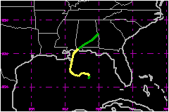
Hanna was a poorly-organized tropical storm that nevertheless produced rip currents responsible for three deaths off the beaches of the Florida panhandle. a. Synoptic HistoryHanna formed in the Gulf of Mexico from a complex interaction of a tropical wave, an upper-level low, and a surface trough. In the days preceding genesis, a broad surface trough in the wake of Hurricane Gustav stretched from the western Atlantic across South Florida and into the central Gulf of Mexico. During this time a westward-moving tropical wave approached the Yucatan peninsula, and when the wave reached the Gulf of Mexico on 10 September a weak 1008-mb low formed on the western end of the surface trough. Initially, there was minimal convection associated with the combination of these two features; however, on 11 September an upper-level short-wave trough over the southern United States cut off over the central Gulf of Mexico, and convection began to develop to the east of the both the upper level low and the tropical wave/surface low. The convection became sufficiently organized to warrant a Dvorak classification at 1800 UTC that day, and over the next 6 hours convection developed closer to the surface low. Shortly before 0000 UTC 12 September a reconnaissance aircraft was able to locate a well-defined low-level circulation center, and with that the ninth depression of the season had formed about 250 nautical miles south of Pensacola Florida. The cyclone initially had some non-tropical characteristics, including a westward tilt with height in association with the upper-low. Despite strong southwesterly shear and a disorganized convective structure, the depression became a tropical storm at 0600 UTC 12 September, about 225 nautical miles south of Pensacola. For the first 24 hours after genesis, the low-level circulation center rotated counter-clockwise around the middle and upper-level centers, first moving northeastward but turning to the southwest by late on 12 September. Moving slowly the following day, Hanna turned to the west and then to the north ahead of an approaching mid-level trough. Hanna strengthened and reached its peak intensity of 58 mph and 1001 mb at 0000 UTC 14 September about 60 nautical miles south of the mouth of the Mississippi River. In response to the approaching trough, Hanna accelerated northward early on 14 September and its exposed low-level circulation center began to become deformed and elongated. With nearly all the significant weather well to its east, Hanna's center of circulation passed over the extreme southeastern tip of Louisiana near 0800 UTC. Hanna then turned to the north-northeast and made its second landfall near the Alabama-Mississippi border near 1500 UTC. Maximum winds at both landfalls were near 58 mph. Hanna moved northeastward across southern Alabama and weakened rapidly, dissipating by 1800 UTC 15 September. The remnants of the tropical cyclone then produced heavy rains as they moved rapidly across Georgia and the Carolinas.
b. Meteorological StatisticsAt 0600 UTC 12 September, buoy 42003 (at 25.9 N, 86.0 W, about 50 nautical miles south-southeast of the center) reported an 8-min mean wind of 37 mph. This observation is the basis for the assignment of tropical storm status at this time. Hanna's peak winds are estimated to be 58 mph, based on surface-adjusted flight-level winds of 53 mph at 2346 UTC 13 September and 54 mph at 1303 UTC 14 September, as well as a 54 mph 2-min wind from the Pensacola ASOS station at 1352 UTC 14 September. The only ship to report tropical storm force winds was KRPP
(Nobel Star), which reported winds of 43 mph and a pressure of 1006.0
mb at 0300 UTC 13 September, when it was about 45 nautical miles west-southwest
of the center. Other observations of note include the aforementioned 54
mph report from Pensacola, the strongest sustained wind observation from
a surface station. The highest gust reported was 68 mph at Pensacola Beach.
. Minor river flooding occurred along Spring Creek near Iron City, Georgia,
where the river crested at 15.3 ft, 1.3 feet above flood stage. 1. Storm SurgeGulfport Harbor reported a storm tide of 5.1 feet, and there were other reports in the 3-5 feet range.2. Rainfall DataHanna and its remnants produced heavy rains across much of the southeastern states. These rains were largely confined to the eastern semicircle of the storm, with numerous reports of storm-total accumulations of between 5 and 10 inches. The highest reported storm total, 15.56 in, was from Donalsonville, Georgia. 3. TornadoesAn F0 tornado that blew down some trees was reported in south Mobile County Alabama.
c. Casualty and Damage StatisticsThree deaths are attributed to rip currents generated by Hanna. An adult male (age 20) drowned in rough surf near Pensacola Beach on the afternoon of the 14th. Two other adult males (ages unknown) drowned, one at Seagrove Beach (Walton County) on the 14th, and another at Panama City Beach on the 15th. Storm effects were relatively minor, and insured losses did
not meet the $25 Million threshold to be
recorded by the American Insurance Services Group. Minor beach erosion
was reported from Dauphin Island, Alabama, to Navarre Beach, Florida,
as well as in the Florida counties of Walton, Bay, and Gulf. Some storm
tide flooding was reported on Dauphin Island and in Mobile County. Roughly
250 homes and 50 businesses were damaged from freshwater flooding in Donalsonville,
Georgia. Data from the Georgia Farm Services Agency indicates agricultural
damage, primarily to the cotton and peanut crops, amounted to nearly $19
Million. There were several other apparently minor flooding events.
Well after Hanna had made landfall and weakened to a tropical depression,
there was a report of a roof being blown off a house in Donalsonville.
Total damage is estimated at $20 million.
Maximum Intensity For Tropical
Storm Hanna
Landfall for Tropical Storm
Hanna
| |||||||||||||||||||||||||||||