|
|
|
|
||||||||||||||||||||||||||||||||||||||||||||
|---|---|---|---|---|---|---|---|---|---|---|---|---|---|---|---|---|---|---|---|---|---|---|---|---|---|---|---|---|---|---|---|---|---|---|---|---|---|---|---|---|---|---|---|---|
|
2002 PRELIMINARY
REPORTS |
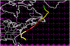
Hurricane Gustav was a category 2 hurricane of subtropical origin. The cyclone passed near the Outer Banks of North Carolina as a tropical storm, then passed over the eastern end of Nova Scotia and western Newfoundland as a category 1 hurricane. a. Synoptic HistoryAn area of showers developed between the Bahamas and Bermuda on 6 September in association with a developing upper-level trough and a weak surface trough. The upper-level trough amplified over the next two days in response to upstream ridging enhanced by Tropical Storm Fay over the Gulf of Mexico. As this occurred, convection increased in both coverage and intensity and the surface trough became better defined. A broad surface low formed in the system late on 7 September. By 1200 UTC 8 September, the cyclone had developed sufficient organized convection to qualify as a subtropical depression about 440 nautical miles south-southeast of Cape Hatteras, North Carolina. Later that day, an Air Force Reserve Hurricane Hunter aircraft investigated the cyclone and found it had become Subtropical Storm Gustav. Gustav moved erratically west-northwestward on 9 September as it slowly strengthened. On that day, the cyclone had a large area of light winds near the center with multiple low-level cloud swirls, and aircraft and satellite position fixes often differed by 30-50 nautical miles. Gustav turned north early on 10 September as convection became better organized near the center. Based on this and the development of a band of strong winds closer to the center, it is estimated that the cyclone transformed into a tropical storm around 1200 UTC. Maximum sustained winds reached 63 mph while the center passed between Cape Hatteras and Diamond Shoals, North Carolina about 2100 UTC that day. It should be noted that while the circulation center stayed offshore (not a "landfall"), the radius of maximum winds (RMW) passed over portions of the Outer Banks and thus counts as a "strike" for this area. Gustav turned northeastward when it reached the Hatteras area, then accelerated northeastward on 11 September in southwesterly flow caused by baroclinic cyclogenesis over the New England states and southeastern Canada. In a complex process similar to that seen in Hurricane Michael in 2000, the tropical cyclone intensified as it gradually began to merge with or absorb the non-tropical low. Gustav became the 2002 season's first hurricane just before 1200 UTC and reached a maximum intensity of 98 mph near 1800 UTC. After that, the cyclone began to weaken. Gustav made landfall over the southern part of Cape Breton, Nova Scotia near 0430 UTC 12 September as an 92-mph hurricane. Satellite, surface, and radar data indicated the cyclone was becoming extratropical as it made a second landfall over southwestern Newfoundland near 0900 UTC. Gustav lost all tropical characteristics by 1200 UTC as it continued northeastward while decelerating across Newfoundland. The remnant extratropical low moved into the Labrador Sea, where it turned northwestward late on 13 September and dissipated on 15 September.
b. Meteorological StatisticsThe maximum winds reported in Gustav were flight-level winds of 120 mph from both Air Force Reserve (at 850 mb) and NOAA (at 700 mb) hurricane hunters around 1900-2000 UTC 11 September. Using standard flight-level to surface reduction for eyewall conditions, the NOAA report would yield a surface wind estimate of 104-109 mph. However, neither aircraft reported an eye or eyewall, so a more conservative reduction for convective bands would yield a surface wind estimate of 98-104 mph. This is in better agreement with the 92-98 mph estimated surface wind from the Air Force aircraft and with an 95 mph surface wind measured by the Stepped Frequency Microwave Radiometer instrument on the NOAA aircraft. The minimum aircraft-reported pressure on a formal fix was 969 mb at 1701 UTC 11 September. However, a dropsonde released later that day near the flight-level wind maximum southeast of the center reported a surface pressure of 964 mb. This suggests that the rapid northeastward motion displaced the wind center of the cyclone to the northwest of the pressure center. Gustav affected many ships and buoys between North Carolina and Nova Scotia. The most notable observations were from the ship Tellus (call sign WRYG), which reported 101 mph and 104 mph winds at 1500 and 1600 UTC 11 September. While these winds are not totally inconsistent with the strength of Gustav at the time, the ship was far enough from the center that the speeds appear somewhat suspect. The oil rig WCY533 near Sable Island reported 85 mph winds and a 965.0 mb pressure at 0300 UTC 12 September. Other noteworthy ship and buoy reports include a 63 mph wind reported by the Columbus Canterbury (call sign ELUB8) near the North Carolina coast at 1900 UTC 10 September and a 964.3 mb pressure from Canadian buoy 44142 at 2300 UTC 11 September. Gustav brought tropical-storm winds to portions of the North
Carolina coast and eastern Nova Scotia. In North Carolina, the Coastal
Marine Automated Network station at Diamond Shoals reported 60 mph sustained
winds with a gust to 70 mph at 1400 UTC 10 September and a 984.8 mb pressure
at 2000 UTC. The Cape Hatteras Coast Guard station reported a gust of
78 mph at 2130 UTC. In Nova Scotia, Sable Island reported 55 mph sustained
winds with a gust to 76 mph at 0414 UTC 12 September, while Hart Island
reported a pressure of 961.4 mb at 0345 UTC. Tropical-storm winds were
also reported on Prince Edward Island as the wind field of Gustav expanded
during extratropical transition. 1. Storm SurgeStorm surge flooding of 5-6 feet above normal tide levels occurred along the inland side of the Outer Banks in Hyde and Dare counties. This occurred during a period of strong northwesterly winds following the passage of the center of Gustav. Storm tides of 3-4 feet above normal were reported in Cedar Island and along the Neuse River. Tides were 1-2 feet above normal elsewhere along the coasts of North Carolina and southeastern Virginia. A 4-5 feet storm surge occurred at Charlottetown, Prince Edward Island. Above normal tides were also reported along the coasts of northern and eastern Nova Scotia and eastern New Brunswick.2. Rainfall DataStorm total rainfalls were 2-5 inches over portions of the Outer Banks, Nova Scotia, and Prince Edward Island. This included a 4.90 inches total at Ocracoke, North Carolina and a 4.25 inches total at Lyon's Brook, Nova Scotia. 3. TornadoesOne tornado occurred during Gustav near Ocracoke.
c. Casualty and Damage StatisticsGustav directly caused one death - a swimmer at Myrtle Beach, South Carolina who suffered injuries from high surf and died two days later. Forty people had to be rescued from storm surge in Hatteras at the height of the storm. Damages from Gustav were minor. Damages to property and vehicles in North Carolina is estimated at about $100,000. In Canada, the worst damage occurred on Prince Edward Island, where whole trees were toppled and local flooding occurred. In Nova Scotia, some docks were damaged and trees were blown down.
Maximum
Sustained Winds For Hurricane Gustav
Minimum
Pressure For Hurricane Gustav
Landfall
for Hurricane Gustav
| |||||||||||||||||||||||||||||||||||||||||||