|
|
|
|
|||||||||||||||||||||||||||||||||||
|---|---|---|---|---|---|---|---|---|---|---|---|---|---|---|---|---|---|---|---|---|---|---|---|---|---|---|---|---|---|---|---|---|---|---|---|
|
2002 PRELIMINARY
REPORTS |
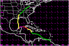
Hurricane Isidore was a slow-moving tropical cyclone that hit western Cuba as a category 1 hurricane (on the Saffir-Simpson Hurricane Scale) and the northern Yucatan Peninsula as a category 3 hurricane. It made landfall on the Louisiana coast as a strong tropical storm. a. Synoptic HistoryA tropical wave moved off the coast of Africa on 9 September accompanied by a large area of thunderstorms. The convective activity decreased significantly as the system moved toward the west-southwest during the next few days, but the wave maintained a good low-cloud signature and cyclonic rotation. As the wave approached 50 West, the shower activity began to increase and an upper-level anticyclone became evident over the system. By 1800 UTC 14 September, there was enough convection and rotation to classify the system as a tropical depression as it approached Trinidad and the northern coast of Venezuela. The depression moved west-northwestward and its development was halted by its interaction with land. By 1800 UTC 15 September, the system had degenerated into a tropical wave in the eastern Caribbean Sea. However, as the wave entered the western Caribbean Sea, it redeveloped a closed circulation and regained tropical depression status at 1200 UTC 17 September, about 120 nautical miles south of Kingston, Jamaica. The depression became Tropical Storm Isidore around 0600 UTC 18 September, and, embedded within a weak steering current, the tropical cyclone moved very slowly toward the northwest, passing just west of Jamaica. Isidore then moved very slowly toward the west-northwest across the Cayman Islands and became a hurricane at 1800 UTC 19 September. Its winds reached 104 mph around 0600 UTC 20 September as it was nearing the southwest coast of the Isle of Youth, Cuba. Although the minimum pressure continued to drop, Isidore's winds decreased a little bit and the hurricane made landfall near Cabo Frances in western Cuba at 2100 UTC 20 September with maximum winds of 86 mph. For more than 12 hours, Isidore relentlessly pounded western Cuba. The hurricane then moved west and southwestward toward the Yucatan Peninsula. Isidore re-strengthened and reached its maximum intensity of 127 mph at 1800 UTC 21 September. However, its minimum central pressure of 934 mb occurred at 1200 UTC 22 September, just before landfall near Puerto Telchac on the north coast of Yucatan. Isidore meandered for 24 to 36 hours over northern Yucatan
and weakened to a minimal tropical storm. It then moved northward over
the Gulf of Mexico where the circulation expanded but the cyclone never
redeveloped an inner core of strong winds. Isidore made landfall with
winds of 63 mph and a minimum pressure of 984 mb just west of Grand Isle,
Louisiana at 0600 UTC 26 September. Once it moved inland, Isidore weakened
to a tropical depression and moved north-northeastward across the southeastern
United States, producing torrential rains. It became an extratropical
storm over southwestern Pennsylvania at 1800 UTC 27 September, and was
then absorbed into a frontal zone. b. Meteorological StatisticsIsidore was upgraded to tropical depression status based on a fix provided by a reconnaissance plane. It was a report of a poorly defined center of 1009 mb with 23 to 29 mph southwesterly winds at 1500 feet around 1800 UTC 14 September. It was downgraded to a tropical wave in the eastern Caribbean Sea the next day, when a reconnaissance plane could not find a closed circulation. Isidore moved very close to the south of Cayman Brac, which reported sustained winds of 48 mph with gusts to 70 mph at 0325 UTC 19 September. During the time Isidore was moving nearby the Isle of Youth, the eye contracted to 8 nautical miles, and based on data from a dropsonde in the eyewall, surface winds were near 104 mph. Thereafter, there was a slight weakening as suggested by data from a reconnaissance aircraft. In fact, the official best track over Cuba was adjusted with data provided by the Cuban Weather Service. Surface observations from Cuba and a post-analysis of aircraft and dropsonde data suggest that Isidore crossed Cuba with 86-mph winds and not with the 98 mph indicated operationally. Several locations in the area reported the calm of the eye. There was a strong storm surge along the south coast of Cuba in Playa Cajio, south of Habana and in Ensenada de Cortes, Pinar del Rio. Isidore's peak intensity of 127 mph at 1800 UTC 21 September, was a compromised between adjusted aircraft flight-level winds and satellite estimates. Although the winds remained unchanged, the central pressure continued to drop to a minimum of 934 mb at 1200 UTC 22 September. At this time, the cloud pattern looked the best one imagery and the three satellite agencies reported T-numbers of 6.5 on the Dvorak scale, corresponding to 146 mph. However, aircraft data did not support such intensity. The maximum winds reported by a station in Yucatan were gusts to 81 mph, with a minimum pressure of 969.9 mb at Merida around 2350 UTC 22 September as the western eyewall moved through the area.. Later, when a weakened Isidore was heading for Louisiana, it reached 63-mph winds based on data from the "Deepwater Pathfinder", which reported sustained winds of 64 mph with gusts to 82 mph and 20 ft waves at 1743 UTC 27 September. Because Isidore was a large tropical cyclone, there were numerous observations from ships of tropical storm force winds. The Belle Chase Naval Air Station in Louisiana experienced northeast winds of 58 mph with gusts 69 mph at 0155 UTC 26 September. This is the highest wind reported by any station as Isidore made landfall in the Louisiana coast.
1. Storm Surge DataThe highest storm surge reported along the U.S. coast was 8.3 feet and occurred at Rigoletes, Louisiana and at Gulfport Harbor, Mississippi.2. Rainfall DataThe minimum pressure measured in western Cuba was 970 mb at Isabel Rubio, and that station experienced gusts to 86 mph at 2140 UTC 20 September and about 554 mm (21.7 in) of rain. 3. TornadoesWhen Isidore was already in the Gulf of Mexico, rainbands over Cuba produced a wind gust of 99 mph in an isolated tornado in the town of Candelaria at 1600 UTC 23 September.
c. Casualty and Damage StatisticsPress reports indicate that there were 2 indirect deaths attributable to Isidore in Merida, Mexico. One was electrocuted by a downed power line, another died in a weather-related car crash. Four direct and one indirect deaths occurred in the United States. One was a marine fatality drowning from a rip current near Port Fourchon, LA on 22 September when Isidore was still over Yucatan, another one was a drowning in a vehicle parked near a casino in Mississippi when storm surge inundated the parking lot. A third died when a tree fell across his car in eastern Mississippi, and the forth one died after driving into 10 feet of water in Clarksville, Tennessee. The indirect death occurred in Mississippi when a man suffered from a cardiac arrest and could not be reached by rescuers due to floodwaters. Damage from Isidore in Jamaica was mainly related to torrential rains. Western Cuba and Yucatan were severely damaged by the hurricane primarily the agriculture and cattle industry. According to Tropical Cyclone Reports from the weather services of Cuba and Mexico, numerous houses and power lines were damaged by wind. In the United States, the Property Claim Services Division of the Insurance Services Office reports that insured losses due to Isidore totaled $165 Million. Using a two to one factor for insured to overall damage gives a total damage estimate of $330 Million. Most of the damage occurred in Louisiana.
Maximum Intensity For Hurricane
Isidore
Landfall for Hurricane Isidore
| ||||||||||||||||||||||||||||||||||