|
|
|
|
|||||||||||||||||||||||||||||||||||
|---|---|---|---|---|---|---|---|---|---|---|---|---|---|---|---|---|---|---|---|---|---|---|---|---|---|---|---|---|---|---|---|---|---|---|---|
|
2002 PRELIMINARY
REPORTS |
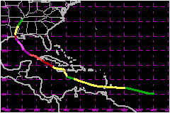
Hurricane Lili crossed western Cuba as a category two hurricane on the Saffir-Simpson Hurricane Scale and made landfall on the Louisiana coast as a category one hurricane. Lili also affected the Windward Islands as a tropical storm, the northeastern Cayman Islands as a category one hurricane and caused serious rainfall flooding in Jamaica. Nine deaths are attributed to Lili. Lili reached category four intensity over the Gulf of Mexico. a. Synoptic HistoryLili originated from a tropical wave that moved over the tropical Atlantic Ocean from the west coast of Africa on September 16th. The wave developed a low -level cloud circulation center midway between Africa and the Lesser Antilles on the 20th. Convective clouds became sufficiently well organized on the 21st to qualify the system as a tropical depression, centered about 900 nautical miles east of the Windward Islands. . Lili's track followed the pressure contours of the southern and western periphery of the semi-permanent Atlantic subtropical high pressure ridge. The tropical cyclone moved just north of due westward at over 23 mph, crossed the Windward Islands as a developing tropical storm on the 23rd and then its winds briefly reached 69 mph on the 24th. The storm weakened to an open tropical wave on the 25th and 26th in the east-central Caribbean as its organization was disrupted by vertical wind shear. Lili re-acquired a low-level closed circulation on the 27th, then its forward speed slowed to about 6 mph by the 28th while beginning a slow northward jog around the north coast of Jamaica. The storm dumped heavy rain on Jamaica over a four-day period. Resuming a west-northwestward track, Lili became a hurricane on the 30th, while passing over Cayman Brac and Little Cayman Islands. The center of the hurricane moved over the southwest tip of
the Isle of Youth on the morning of October 1st, and over western mainland
Cuba a few hours later, with wind speeds as high as 104 mph. Gradually
accelerating its forward speed to about 17 mph, Lily turned northward
and made landfall on the Louisiana coast on the 3rd, with an estimated
92-mph maximum wind speed. However, between Cuba and Louisiana, Lili intensified
to 144 mph early on the 3rd over the north-central Gulf of Mexico and
then rapidly weakened to 92 mph during the 13 hours until landfall. Lili
was absorbed by an extratropical low on the 4th while moving northeastward
near the Tennessee/Arkansas border. Lili was the first hurricane to make
landfall in the United States since Irene
hit Florida in 1999. b. Meteorological StatisticsSustained wind speeds were near 52 to 58 mph as Lili moved quickly across the Windward Islands. A sustained wind speed of 54 mph with a gust to 78 mph was observed at Martinique early on the 24th. The forward motion slowed to six mph as Lili moved between Haiti, Jamaica and eastern Cuba. This slow motion contributed to the copious rainfall over Jamaica from the 27th through the 30th, where over 20 inches of rainfall was recorded. Lili developed an eye which passed over the Isle of Youth and then western mainland Cuba on October 1st. The highest wind report from Cuba was a ten-minute average of 100 mph with a gust to 113 mph from Francia on the Isle of Youth and this is the basis for a best-track wind speed of 104 mph over Cuba. The highest aircraft -measured flight-level wind speed during this time was 100 mph. The highest best-track wind speed is estimated at 144 mph at 0000 UTC on the 3rd, while the hurricane was centered in the north-central Gulf of Mexico. This is based on an aircraft 700-mb flight-level wind speed of 163 mph along with 938-mb surface pressure. The aircraft flight level-wind speed reduces to a surface wind of 147 mph using a 90 percent eyewall reduction factor. There were also several GPS-sonde surface wind speed measurements of 132 to 141 mph near this time. The east eye wall passed over NOAA data buoy 42001 at 2000 UTC on the 2nd. This buoy reported a ten-minute wind speed of 113 mph with a gust to 150 mph, which is the highest wind speed ever recorded by a National Data Buoy Center buoy. Hurricane Lili made landfall along the south-central coast of Louisiana near Intracoastal City. The highest observed sustained wind over land is 74 mph, from a Texas Tech. tower near Kaplan or about 15 nautical miles north-northwest of Intracoastal City. The highest recorded wind gust is 120 mph at Intracoastal City. The highest aircraft flight level wind speed near the time of landfall is 101 mph at 700 mb. The highest surface wind speed estimate obtained from GPS- sondes during the last few hours before landfall is 84 mph. A mobile SMART radar measured 116 mph just above the surface south of New Iberia. The lowest surface pressure observed was 963.9 mb at the Louisiana Agriclimate Information System at Crowley. Based on the above data, the best-track maximum wind speed at landfall is estimated at 92 mph. The landfall area is sparsely populated. Most of southern Louisiana experienced sustained winds of 75 mph or less. Lili's eyewall collapsed as its wind speed decreased during the 13 hours before landfall. The radius of maximum wind speed may not have been close to the center at landfall. Aircraft Flight level winds near the coast just south of Morgan City suggest that the highest winds were perhaps 50 nautical miles east of the center, so that wind speeds near the coast south of Morgan City could have been as high or higher than wind speeds near Intracoastal City, where the center crossed the coast.
1. Storm Surge DataA tide gage at Crewboat Channel near Calumet measured a storm tide water height of 12.3 feet and another at Vermillion Bay measured 11.7 feet. The water height at Burn's Point, south of Morgan City, is estimated at 10 to 12 feet above normal, based on the observed water level inside a house. A combination of storm surge and heavy rain caused levees to fail at Montegut and Franklin, Louisiana. Tide gauge waters levels were already 2 to 4 ft above normal prior to Lili's arrival.2. Rainfall DataLili slowly moved between Haiti, Jamaica and eastern Cuba and dropped over 20 inches of rainfall.Over six inches of rainfall was recorded at locations in Granma and Santiago de Cuba provinces in eastern Cuba. Rainfall across south-central and southeastern Louisiana ranged from four to eight inches, with the highest amount of 8.57 inches at Perry, just north of Intracoastal City. Over four inches was measured in northern Louisiana and southern Mississippi and over two inches spread into Arkansas. Portions of Florida and Alabama had over an inch of rain. 3. TornadoesTornadoes were reported in Acadia, Evangeline, Lafayette, Rapides, and St. Landry Parishes. Most were short-lived and damage was in the F-0 to F-1 range on the Fujita scale.
c. Casualty and Damage StatisticsThere were 9 deaths attributed to Lili; 4 in St. Vincent,
4 in Jamaica & 1 in Cuba. Jamaica was hard hit by heavy rain from Lili. Four people, including a 3-year-old child, died when flood waters swept them away. Flood waters also swept away livestock and crops and caused extensive damage to homes, bridges, roadways, and other infrastructure. Flood damage was compounded by heavy rain earlier in September from Hurricane Isidore. This is also the case with rainfall over western Cuba and Louisiana. Lili also pelted Haiti's south coast with wind and rain. There are news reports of high winds uprooting trees, knocking out electricity and damaging roofs in Cayman Brac in the northeastern Cayman Islands. The hurricane cut a swath of destruction across western Cuba, damaging buildings and farmland and disrupting communications. Some 360,000 people were reported to have been evacuated from their homes. There was one direct death in Pinar del Rio province. Lili made landfall on the central Louisiana coast as a category one hurricane and left behind a trail of muck and misery from widespread wind and flood damage. Strong winds toppled trees onto houses and into roadways, stripped shingles from roofs, and blew out windows. The wind and driving rain flattened sugar cane fields throughout southern Louisiana. A combination of storm surge and rain caused levees to fail in the southeastern part of the state. Lili also temporarily curtailed all oil production in the Gulf of Mexico. Damage total from the American Insurance Services Group is $430 Million, $415 Million for Louisiana and $15 Million for Mississippi. The total dollar damage estimate is twice this value or $860 Million. President Bush declared that Louisiana is eligible for federal assistance. One indirect fatality occurred in Crowley, Louisiana, when
an elderly woman died from carbon monoxide poisoning from a generator.
Another indirect fatality occurred in Vermilion Parish where a 79 year
old Erath man died when he fell from a ladder cleaning up storm debris.
Maximum Intensity For Hurricane
Lili
Landfall for Hurricane Lili
| ||||||||||||||||||||||||||||||||||