|
|
|
|
||||||||||||||||||||||||||||||
|---|---|---|---|---|---|---|---|---|---|---|---|---|---|---|---|---|---|---|---|---|---|---|---|---|---|---|---|---|---|---|
|
2002 PRELIMINARY
REPORTS |
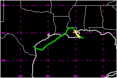
Bertha was a minimal tropical storm that made landfall in southeastern Louisiana. a. Synoptic HistoryBertha had a non-tropical origin, forming from the same non-tropical surface trough of low pressure that spawned Tropical Storm Cristobal in the western North Atlantic Ocean. This trough extended from the north central Gulf of Mexico across Florida into the Atlantic on 1 August and moved little for the next two days. A broad low pressure area was first noted on 3 August. Satellite, surface, and radar observations indicated the low became better organized just east of the mouth of the Mississippi River on 4 August, and the system developed into Tropical Depression Two around 1800 UTC that day. The depression strengthened further as it moved west-northwestward. An Air Force Reserve Hurricane Hunter aircraft indicated the system became Tropical Storm Bertha near 2300 UTC 4 August. The broad center made landfall near Boothville, LA about two hours later. After landfall, Bertha assumed a wobbly northwestward motion that took the center to the north of Lake Ponchartrain later on the 5th. The cyclone weakened back to a depression at 1200 UTC that day. Bertha maintained its circulation over land while moving slowly
westward and then southward on 6 August. It began a southwestward motion
on the 7th, which brought the center back to the Gulf of Mexico
around 0900 UTC that day. This motion continued until late on 8 August.
While satellite and radar data showed periods of increased organization,
surface and aircraft observations showed only slight strengthening at
most over the northwestern Gulf. The cyclone turned west-northwestward
late on the 8th, and this motion brought the center to the
Texas coast east of Kingsville around 0800 UTC 9 August. Bertha weakened
quickly after landfall and dissipated over southern Texas later that day. b. Meteorological StatisticsTropical Depression Two was upgraded to Tropical Storm Bertha
on the basis of an aircraft report of 54 mph flight-level winds north
of the center at 850 mb. The highest surface winds measured during the
storm were at NOAA buoy 42007, which reported 38 mph 10-minute average
winds at 2240 UTC 4 August and 0310 UTC 5 August. The buoy reported a
peak gust of 49 mph at 0441 UTC on the 5th. A nearby station
run by Louisiana State University reported a 39 mph wind gust at 0000
UTC on the 5th. The highest wind at a coastal site was a gust
of 41 mph at an National Ocean Service station in Waveland, MS. 1. Storm SurgeStorm tides reached as high as 3-4 feet -- 1-2 feet above normal tide levels -- along portions of the Mississippi and southeastern Louisiana coasts.2. Rainfall DataRainfall totals associated with Bertha were mainly in the 3-6 inch range. There were locally heavier amounts, including reports of 10.25 inches at Pascagoula, MS and Norwood, LA.
c. Casualty and Damage Statistics
Press reports indicate one death associated with Bertha - a drowning in high surf at Perdido Key State Park, FL on 4 August. Rains associated with Bertha produced areas of stream and street
flooding, which affected some structures producing minor damage. No monetary
damage figures are available.
Maximum Intensity For Tropical
Storm Bertha
Landfall for Tropical Storm
Bertha
| |||||||||||||||||||||||||||||