|
|
|
|
|||||||||||||||||||||||||
|---|---|---|---|---|---|---|---|---|---|---|---|---|---|---|---|---|---|---|---|---|---|---|---|---|---|
|
2002 PRELIMINARY
REPORTS |
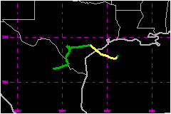
Tropical Storm Fay was a short-lived cyclone that made landfall along the central Texas producing widespread heavy rainfall and inland flooding. a. Synoptic HistoryTropical Storm Fay developed from an area of disturbed weather that included a broad, non-tropical low pressure system over the northwestern Gulf of Mexico. During the first few days of September, a broad mid- to upper-level trough moved southward from the United States and became stationary across the northern Gulf of Mexico. Thunderstorms developed along a surface low pressure trough that hugged the northern Gulf of Mexico coastal areas. Gradually, the trough and a series of weak low pressure systems drifted southward over the warm waters (sea-surface temperatures > 30� C) of the Gulf. A low in the northwestern Gulf of Mexico became the dominant circulation and developed persistent deep convection near the low-level center by 4 September. On 5 September, an Air Force Reserve Reconnaissance aircraft investigated the system when it was centered about 85 nautical miles southeast of Galveston, Texas. During the flight, a broad, closed circulation and sufficient winds were found to estimate that a tropical depression had formed at 1800 UTC. The depression moved steadily south-southwestward and strengthened fairly quickly. The depression became Tropical Storm Fay at 0000 UTC 6 September about 110 n mi southeast of Galveston. Fay moved south-southwestward for 12 hours before turning toward the west where it reached a peak intensity of 58 mph by 1200 UTC that day about 125 nautical miles southeast of Galveston. Shortly thereafter, Fay turned and moved erratically in a general west-northwestward direction and maintained its 58 mph intensity for nearly 24 hours until landfall occurred at 0900 UTC 7 September on the southern Matagorda Peninsula about 10 n mi east of Port O'Connor, Texas. After making landfall, the broad circulation reformed farther north, about 25 nautical miles northwest of Palacios. Fay then made a sharp turn toward the west and accelerated to about 17 mph. With more of the circulation being over land, the faster forward speed hastened the weakening process and by 0600 UTC 8 September, Fay had degenerated into a remnant low pressure system about 30 nautical miles southwest of Hondo, Texas. However, the rather tenacious remnant low meandered across southern Texas and northeastern Mexico for another 3 days producing copious amounts of rainfall before finally dissipating about 65 nautical miles northwest of Monterrey, Mexico.
b. Meteorological StatisticsFay's peak intensity of 58 mph from 1200 UTC 6 September to 0900 UTC 7 September (near landfall) is based on a blend of a reconnaissance flight-level spot wind report of 78 mph and larger area of 69 mph wind, which convert to surface wind values of 62 mph and 55 mph, respectively, and a pressure-wind relationship surface wind estimate of approximately 49 mph. This lower maximum wind speed is believed to be more representative of Fay's overall circulation since the isolated peak flight-level wind speed of 78 mph was well removed from the circulation center. In addition, after the center of Fay moved inland, the converted flight-level-to-surface wind speed estimate of 71 mph that was observed over land on 7 September was not considered to be representative since it was associated with a large nocturnal thunderstorm complex and little or no thunderstorm activity existed over water. The minimum pressure of 998 mb at 0000 UTC 7 September was based on a reconnaissance aircraft extrapolated surface pressure from 1500 ft. The 58 mph surface wind value at landfall along the central
Texas coast is consistent with previous flight-level-to surface wind conversions
when the center of Fay was still offshore and is close to the pressure-wind
relationship value of 54 mph. The interpolated landfall minimum pressure
of 999 mb is based on a reconnaissance aircraft extrapolated (from 1500
ft) surface pressure of 999.9 mb that was reported approximately 40 nautical
miles northeast of the center. 1. Storm SurgeMaximum storm surge values were generally around 2 -3 feet all along the Texas coast. Along the Louisiana coast, west of Cameron, storm surge values ranged from 1.5 to 2.5 feet and caused minor beach erosion and coastal highway flooding.2. Rainfall DataRainfall totals across the San Antonio metropolitan area ranged from 4 to 8 inches with some isolated reports in excess of 11 inches. Across the remainder of south-central Texas, rainfall totals exceeded 9 to 12 inches at several locations, with a total of 17.29 inches reported at Fowlerton.Heavy rainfall and widespread inland freshwater flooding occurred across the upper Texas coastal area, north of where the center of Fay passed. Rainfall totals across the Upper Texas coast and in the Houston metropolitan area ranged from 8 to 12 inches in many areas, with some estimated rainfall totals of 20 to 24 in near the town of Sweeney. 3. TornadoesSeveral tornadoes were spawned by Fay before and after the system moved inland.Five tornadoes occurred in association with Tropical Storm Fay. Four of the tornadoes developed across the upper Texas coastal area on 6 September and one was reported near Premont in south-central Texas on the evening of 8 September. A funnel cloud was also sighted 3 miles west of Belmont, Texas during the early evening of 6 September.
c. Casualty and Damage StatisticsNo deaths were reported in association with Fay. Insured
losses did not meet the $25 Million threshold
in order to be recorded by the American Insurance Services Group and total
flood-related damages are not available at this time. No monetary damage
figures are available from Mexico. Severe floods occurred across much of the upper Texas coastal area. In Galveston County, 135 residential structures were affected by Fay, with 23 receiving major damage that totaled about $500,000 in losses. In Brazoria county, more than 1500 homes and nearly 500 cars were flooded. In Matagorda County, 130 single-family homes and 32 businesses were damaged by flood waters. In addition, over $1 Million in damage was done to public facilities, including roads, bridges, and public buildings. In Wharton County, nearly 200 single-family homes were damaged or destroyed by flood waters. After moving inland and dissipating as a tropical cyclone, the remnant low generated widespread showers and thunderstorms which, in turn, produced torrential rainfall and widespread flooding across the region. Some homes and businesses across the area were damaged due to the floods. Ten homes were damaged due to floods in La Coste in Medina County, while another 20 homes were damaged in Pearsall in Frio County. Widepread minor damage also occurred to roads and bridges across Bexar, Medina, Wilson, Atascosa, Frio, Comal, and Guadeloupe Counties due to the floods. In contrast, the remnants of Fay brought much needed rainfall to help alleviate water shortage problems in the drought-stricken regions of west-central and south Texas. On 6 September, the first tornado destroyed a beach house in
Surfside; a second tornado hit west Columbia knocking down numerous trees
along Highway 36; the third and most significant tornado touched down
in extreme eastern Fort Bend County destroying one mobile home and injuring
2 people; this same tornado later crossed the San Bernard River into Wharton
County where it destroyed another mobile home and heavily damaged two
others; the fourth tornado caused minor damage to 4 single-family homes
near Hungerford in Wharton County. A funnel cloud that was sighted on
6 September and a tornado that was observed on 8 September produced no
damage.
Maximum Intensity For Tropical
Storm Fay
Landfall for Tropical Storm
Fay
| ||||||||||||||||||||||||