|
|
|
|
|||||||||||||||||||||||||
|---|---|---|---|---|---|---|---|---|---|---|---|---|---|---|---|---|---|---|---|---|---|---|---|---|---|
|
2002 PRELIMINARY
REPORTS |
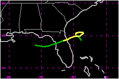
Edouard made landfall on the northeast coast of Florida as a minimal tropical storm. a. Synoptic HistoryEdouard formed from a disturbance of non-tropical origin. Cloudiness and isolated showers developed several hundred miles east-southeast of Bermuda on 25 August, likely in association with a low-level disturbance that had formed along a dying frontal zone. The system moved southwestward for several days, and when the disturbance was located near the southwest end of an upper-level trough a few hundred miles north of Puerto Rico, deep convection associated with the system increased. The area of disturbed weather moved slowly westward over the next couple of days, and on the 31st, when the system was located just to the east of the northern Bahamas, it began to become better organized. On 1 September deep convection became persistent, and surface and reconnaissance aircraft data indicate the system became a tropical depression around 1800 UTC that day, centered about 120 n mi east of Daytona Beach, Florida. In the early stage of the tropical cyclone, the environment was characterized by modest west-northwesterly shear, and the system strengthened into Tropical Storm Edouard by 0600 UTC 2 September. Later that day and early on the 3rd, the environment appeared to become more hostile. Water vapor imagery suggested that dry mid- to upper-tropospheric air was overspreading the center, and radiosonde data indicated 35 to 46 mph winds affecting the storm at the 200 mb level. Despite this, Edouard was able to intensify further, and it reached its peak strength of 63 mph around 1200 UTC 3 September. However, very soon thereafter, the storm soon began to succumb to the influence of strong shear and dry air aloft and a weakening trend was underway. By midday on the 3rd, the associated deep convection had decreased, and the low-cloud circulation center was clearly exposed. Soon after Edouard's genesis, steering currents weakened. From
2-3 September, the cyclone moved in a clockwise loop. Then, as a weak
and narrow mid-tropospheric ridge developed to its north, Edouard headed
erratically westward and west-southwestward toward the northeast coast
of Florida. Strong shear continued to impact the system, and although
occasional bursts of deep convection occurred near the center, the cyclone
was barely of tropical storm strength when the center crossed the coastline
in the vicinity of Ormond Beach, Florida around 0045 UTC 5 September.
Edouard weakened to a depression almost immediately after landfall, and
crossed north-central Florida. The weak depression emerged into the Gulf
of Mexico near Crystal River, Florida around 1400 UTC on the 5th.
Strong northwesterly shear, associated with the upper-tropospheric outflow
from developing Tropical Storm Fay located
over the western Gulf, precluded any redevelopment of Edouard. On the
6th, Tropical Depression Edouard moved westward over the northeastern
Gulf, and by 1200 UTC on that day, it was a rather insignificant-looking
low cloud swirl with minimal deep convection. The system dissipated shortly
thereafter, as it became absorbed into the larger circulation of Tropical
Storm Fay. b. Meteorological StatisticsThe peak intensity of Edouard, 63 mph, is based on a reconnaissance aircraft wind measurement of 82 mph at a flight level of about 1000 ft at 1159 UTC 3 September. There were no reports of sustained tropical storm force winds
over land associated with Edouard. On 4 September, Patrick Air Force Base
reported a peak wind gust of 39 mph at 2127 UTC , and the St. Augustine
C-MAN station reported a peak gust of 38 mph at 1900 UTC. 1. Rainfall DataReliable rainfall estimates from the Melbourne radar indicated maxima of 4 to 5 inches near the Seminole/Orange County line, just northeast of Union Park (Orange County) Florida.
c. Casualty and Damage StatisticsThere were no reports of casualties due to Edouard. Some
flooding occurred in Brevard, Seminole, and Orange counties in Florida.
This appears to have been mainly roadway flooding and damages, if any,
appeared to be minor. No dollar amounts are available.
Maximum Intensity For Tropical
Storm Edouard
Landfall for Tropical Storm
Edouard
| ||||||||||||||||||||||||