|
|
|
|
||||||||||||||||||||||||||||||
|---|---|---|---|---|---|---|---|---|---|---|---|---|---|---|---|---|---|---|---|---|---|---|---|---|---|---|---|---|---|---|
|
2002 PRELIMINARY
REPORTS |
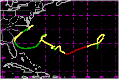
Hurricane Kyle was a category 1 hurricane (on the Saffir-Simpson Hurricane Scale) that lasted for 22 days and became the third longest-lived tropical cyclone in the Atlantic basin. Kyle eventually made landfall along the southeastern United States coast as a weak tropical storm before moving back out to sea. a. Synoptic HistoryKyle formed from a non-tropical low pressure system in the central North Atlantic Ocean. A cold front moved across Bermuda on 13 September and stalled to the southeast of the island by 15 September. The stationary front gradually weakened and became an elongated area of low pressure by 18 September. A sharp mid-level shortwave trough moved off the southeast coast of the United States and likely acted as the triggering mechanism for the development of a stationary low pressure center by 1200 UTC 19 September about 750 nautical miles east-southeast of Bermuda. Thunderstorms gradually developed into narrow bands a few hundred miles away from the well-defined low-level circulation center. Surface winds gradually increased to 29 mph early on 20 September and the overall satellite cloud pattern became much better organized. At 1800 UTC that day, it is estimated that Subtropical Depression Twelve had developed about 715 nautical miles east-southeast of Bermuda. Later that day, the system made a clockwise loop as it became embedded in the weak steering flow region(or "col") between its parent upper-level low to the south and a mid-latitude trough to the north. Based on Dvorak satellite intensity values, it is estimated that the cyclone became Subtropical Storm Kyle at 0600 UTC 21 September when it was about 680 nautical miles east of Bermuda. While making the loop, thunderstorms developed around the low-level center and Kyle gradually acquired warm-core tropical characteristics. It is estimated that Kyle became a tropical storm at 1800 UTC 22 September about 760 nautical miles east of Bermuda. Under the influence of weak steering currents, Tropical Storm Kyle drifted erratically toward the southwest for about a week and steadily intensified. Kyle became a hurricane at 1200 UTC 25 September about 550 nautical miles east-southeast of Bermuda. A peak intensity of 86 mph is estimated to have occurred at 1200 UTC 26 September about 425 nautical miles east-southeast of Bermuda. Kyle maintained this intensity for the next 24 hours before gradually weakening under the influence of moderate northwesterly to northerly vertical shear. After Kyle weakened below tropical storm strength at 1800 UTC 30 September, the cyclone made a slow counter-clockwise loop about 300 nautical miles west of Bermuda from 5-8 October. Afterwards, Kyle moved westward and then northwestward before making landfall along the South Carolina coast late on 11 October. During this period, fluctuations in intensity occurred and Kyle strengthened back into a tropical storm on 1, 6, and 11 October. After making its first landfall near McClellanville, South Carolina at around 1700 UTC 11 October, Tropical Storm Kyle moved northeastward and skirted the remaining upper coastline of South Carolina. Its center moved inland again a few hours later near Long Beach, North Carolina around 2200 UTC. Kyle weakened to a tropical depression by 0000 UTC 12 October near Surf City, North Carolina and then strengthened back into a tropical storm over Pamlico Sound six hours later. Shortly thereafter, it exited the eastern portion of the state near Nags Head at around 0800 UTC. The cyclone eventually merged with a cold front later that day at 1200 UTC, when it was located about 280 nautical miles south-southwest of Nantucket, Massachusetts. Kyle lasted for 22 days making it the third longest-lived Atlantic tropical cyclone, after Ginger of 1971 and Inga of 1969.
b. Meteorological StatisticsKyle's peak intensity of 86 mph from 1200 UTC 26 September to 1200 UTC 27 September is based on a blend of subjective and 3-hour objective Dvorak satellite intensity estimates. The minimum pressure of 980 mb at 0000 UTC 27 September is estimated based Dvorak satellite intensity estimates, and on the best appearance and definition of the eye in both visible and infrared satellite imagery. The 40-mph intensity at landfall along the South and North Carolina coasts was based on a blend of 1500 ft flight-level winds of 44 mph (reduced to 37 mph surface wind estimate) and offshore buoy reports of 10-minute average wind speeds of 40 mph with gusts to 46 mph. However, tropical storm force winds were confined to offshore waters in the eastern semicircle and there were no reports of sustained tropical storm force winds along or inland of the United States coast.
1. Storm Surge DataStorm surge values were generally around 1 ft from Florida to North Carolina, with a few isolated occurrences of near 2 ft at Fort Pulaski, Georgia and at Charleston Harbor, South Carolina.2. Rainfall DataRainfall totals were generally less than 2 in with a few isolated amounts of 5-6 in reported. Minor urban flooding occurred. 3. TornadoesAt least 4 tornadoes were reported across eastern South Carolina and southeastern North Carolina during Kyle's passage.
c. Casualty and Damage StatisticsAs a result of the relatively weak sustained winds at landfall, Kyle caused no significant structural damage and only minor beach erosion was reported along the North Carolina and South Carolina coastlines. In South Carolina, an F2 tornado touched down in Georgetown, and tossed and severely damaged 5 mobile homes and a car. Twenty-five additional structures sustained at least minor damage. Eight people were injured. In North Carolina, a damaging F1-F2 tornado touched down near Pantego, in Beaufort County. The tornado flipped one mobile home, blew the roof off of one house, and destroyed 7 hog houses on Benson Farms, which resulted in $1.5-2.0 million in damage . Weaker tornadoes touched down in Belvoir and overturned two mobile homes and knocked a house off its foundation. Another weak tornado touched down east of Washington, North Carolina causing no damage. No injuries were reported with any of the North Carolina tornadoes. The reported insured losses associated with Kyle were approximately $2.5 Million. Total damages is estimated at $5 Million. No deaths were reported in association with Kyle.
Maximum Intensity For Hurricane
Kyle
Landfall for Hurricane Kyle
| |||||||||||||||||||||||||||||