|
|
|
|
|||||||||||||||
|---|---|---|---|---|---|---|---|---|---|---|---|---|---|---|---|
|
1998
PRELIMINARY REPORTS |
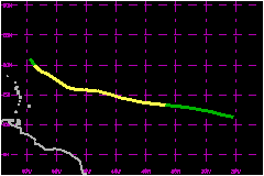
Alex was the first tropical cyclone of the 1998 season and remained over the open waters of the tropical Atlantic throughout its lifetime. a. Synoptic HistoryA well-organized tropical wave emerged from the west coast
of Africa on 26 July and moved westward at 17 to 23 mph. Early on 27th,
ship reports and satellite scatterometer winds supported the presence
of a surface circulation in association with the wave. On this basis,
it is estimated that the system attained tropical depression status around
1200 UTC 27 July while located about 300 nautical miles south-southwest
of the Cape Verde Islands. The depression changed little in organization on 27 July
and most of the 28th, with minimal deep convection near the center, while
moving on a general west-northwestward track at 17 to 23 mph. During this
period, satellite imagery characterized the depression as a large and
elongated circulation which was still involved with the Intertropical
Convergence Zone. By the evening of the 28th, deep convection increased
near the center and meteorologists from both the Tropical Analysis and
Forecast Branch (TAFB) at the Tropical Prediction Center and the Satellite
Analysis Branch (SAB) from the National Environmental Satellite, Data,
and Information Service assigned Dvorak T-numbers of 2.5, i.e., 40 mph.
Consequently, the system was upgraded to Tropical Storm Alex at 0000 UTC
29 July. Alex continued to move on a general west to west-northwest
course at 12 to 17 mph in response to a deep-layer ridge over the tropical
eastern Atlantic. During the next several days, Alex's development was
hampered by a mid- to upper-level trough, and attendant cyclonic circulation,
located to its north and west. By 30 July, satellite imagery indicated
that Alex was experiencing southerly vertical wind shear. During the evening
of the 30th, satellite imagery showed a burst of deep convection just
east of the center. It is estimated that Alex reached a peak intensity
of 52 mph from 1800 UTC 30 July to 0600 UTC 31 July, and a minimum central
pressure of 1002 mb near 0000 UTC 31 July. Shortly thereafter, increased
southerly vertical wind shear induced by the mid- to upper-level tropospheric
trough to the west of Alex curtailed further strengthening. Over the next few days the vertical wind shear took its toll
with the low-level center of Alex becoming fully exposed south of the
remaining deep convection on 1 August. Alex turned toward the northwest
later that day and continued to gradually weaken. Alex was downgraded
to a depression by midday on the 2nd. Later that afternoon, data from
an Air Force Reserve Hurricane Hunter reconnaissance aircraft showed that
the system no longer had a closed low-level circulation, and the system
dissipated. b. Meteorological StatisticsThere were no surface observations of tropical storm force
winds in association with Alex. c. Casualty and Damage StatisticsAlex is not known to have caused any casualties or damages.
Maximum
Intensity For Tropical Storm Alex
| ||||||||||||||