|
|
|
|
|||||||||||||||||||||||||||||||||||||||
|---|---|---|---|---|---|---|---|---|---|---|---|---|---|---|---|---|---|---|---|---|---|---|---|---|---|---|---|---|---|---|---|---|---|---|---|---|---|---|---|
|
1998
PRELIMINARY REPORTS |
a. Synoptic HistoryThe origin of Tropical Storm Charley is unclear. It could
have been a large swirl of clouds that exited the coast of Africa on 9
August at rather high latitude, mainly to the north of Dakar, Senegal.
More definitely, the precursor consisted of a small area of deep convection
first noted a few hundred miles to the northeast of the Leeward Islands
on the 15th. Intermittent convective activity continued while the system
moved just west of north for the following few days. On the 19th, animation
of satellite pictures showed a cyclonic rotation of the clouds over the
southeastern Gulf of Mexico. The first formal position estimate from satellite analysts
came on the evening of the 19th and Dvorak T-numbers (1.5) were first
assigned the next day over the central Gulf. By the morning of the 20th,
surface winds had begun to increase, with NOAA's central Gulf buoy 42001
measuring sustained winds as high as 36 mph and gusts to 52 mph at
1700 UTC. These stronger winds were fleeting, however, and an investigation
of the system late that day by U.S. Air Force Reserves reconnaissance
aircraft did not indicate a closed low-level circulation center. A center "fix" was made aboard reconnaissance aircraft early
in the following flight, near 1300 UTC the next day, and this is the basis
for indicating that the system became a tropical depression around 0600
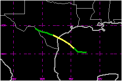
UTC on the 21st. At that time, the depression was centered about 275 nautical miles off of the south Texas coast. The tropical cyclone moved toward the
west-northwest to northwest at about 12 mph during its three-day lifetime.
Although the center was not well-formed initially, the amount
of deep convection steadily increased, particularly over the northern
semicircle. That part swept over the oil platforms of the northern Gulf
and data from them (e.g., Table 2) suggest that tropical storm status
was reached by 1800 UTC on 21 August. Winds of hurricane force were noted
in intense convection to the northeast of the center at a flight level
of 1500 feet early on the 22nd. Charley was likely then at its peak strength,
near 69 mph. The wind speeds measured aboard aircraft were considerably
lower thereafter and it is estimated from that data and other observations
that surface winds were closer to 46 mph when Charley's center made
landfall near Port Aransas about 1000 UTC on the 22nd. The surface circulation weakened further after landfall and
likely dissipated early on the 24th along the Rio Grande near Del Rio,
Texas. Although the winds diminished inland, and a closed surface circulation
could no longer be identified, a slow-moving circulation aloft persisted
in the Del Rio vicinity and generated flooding rains that were most devastating
in that area on the 23rd and 24th. By late on the 25th, most of the remnant
cloud system had deteriorated and precipitation had diminished. b. Meteorological StatisticsThe ASOS sites at Rockport (RKP) and Galveston (GLS), Texas
were the only two surface reporting stations on land to measure sustained
tropical storm force winds. They recorded 2-minute winds of 41 mph and
39 mph, respectively. A gust to 63 mph was reported from the Pt. O'Connor
Coast Guard. A minimum pressure of 1000 mb is estimated at landfall from
the observation of 1000.7 mb at RKP an hour later. 1. Storm Surge DataStorm tides of 2 to 3.5 feet above normal astronomical levels
were reported from the coast. 2. Rainfall DataCharley's primary legacy will be the rainfall and associated
flooding it produced in the Del Rio vicinity. On 23 August, 16.83 inches
of rain fell in Del Rio. This easily surpassed the previous daily record
of 8.79 inches on 13 June 1935. A nearby site recorded 17.59 inches for
the 24 hour period ending in the morning hours of 24 August. Along the
coast, maximum rainfall totals were near 5 inches except for an unofficial
report of 9 inches near the mouth of the San Bernard River in Brazoria
County. River flooding along the Rio Grande occurred well downstream
from Del Rio, in the Laredo area. c. Casualty and Damage StatisticsThere were 20 deaths attributed to Charley; 13 in Texas and
7 in Mexico. Emergency operations personnel in Mexico reported that as
of early October the number of fatalities in Ciudad Acuña, Mexico,
across the border from Del Rio, was seven. Media reports indicate that
three of these victims drowned while trying to cross a flooded gully. A preliminary estimate of the total loss due to the inland
flood is $50 Million.
Property losses were reported in several counties and consisted of damages
to residences, businesses, roads, bridges and agriculture. About 1500
homes, 200 mobile homes, and 300 apartments were damaged or destroyed
in Val Verde County, where about $40 Million
in losses occurred. Minor beach erosion was reported.
Maximum
Sustained Winds For Tropical Storm Charley
Minimum
Pressure For Tropical Storm Charley
Landfall
for Tropical Storm Charley
| ||||||||||||||||||||||||||||||||||||||