|
|
|
|
|||||||||||||||||||||||||||||||||||||||||||||||||||||||
|---|---|---|---|---|---|---|---|---|---|---|---|---|---|---|---|---|---|---|---|---|---|---|---|---|---|---|---|---|---|---|---|---|---|---|---|---|---|---|---|---|---|---|---|---|---|---|---|---|---|---|---|---|---|---|---|
|
1998
PRELIMINARY REPORTS |
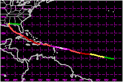
Georges (pronounced Zhorzh) was the second deadliest and second strongest hurricane within the Atlantic basin during the 1998 season. Its 17 day journey resulted in seven landfalls, extending from the northeastern Caribbean to the coast of Mississippi, and 602 fatalities -- mainly in the Dominican Republic and Haiti. a. Synoptic HistoryGeorges originated from a tropical wave, observed by satellite
and upper-air data, which crossed the west coast of Africa late on 13
September. Rawinsonde data from Dakar, Senegal showed an attendant 40
to 52 mph easterly jet between 550 and 650 millibars (mb). On the 14th,
visible satellite imagery depicted a large, well-defined cloud system
in association with the wave and meteorologists at the Tropical Prediction
Center/National Hurricane Center (NHC) Tropical Analysis and Forecast
Branch (TAFB), the Satellite Analysis Branch (SAB) of the National Environmental
Satellite, Data, and Information Service, and the Air Force Weather Agency
(AFGWC) began satellite-based Dvorak intensity classifications. By early
on the 15th, ship reports indicated the presence of a closed surface circulation
in this system and it is estimated that a tropical depression formed at
1200 UTC, centered about 300 nautical miles south-southwest of the Cape
Verde Islands in the far eastern Atlantic, as shown in the post-storm
"best-track". During the next 24 hours the tropical depression continued
to become better organized as banding features developed and deep convection
formed over the center. The system became a tropical storm at 1200 UTC
on 16 September while centered about 620 nautical miles west-southwest
of the Cape Verde Islands. Georges moved on a persistent west-northwest
course for the next ten days, a classic Cape Verde-type track, in response
to a mid- to upper-level tropospheric ridge which strengthened with height. Georges continued to gradually strengthen over the next several
days, reaching hurricane intensity around 1800 UTC on 17 September when
a banding-type eye feature became evident in satellite imagery. By the
19th, an upper-level anticyclone was well-established over Georges and
satellite pictures suggested that the hurricane was beginning to strengthen
rapidly, as indicated by the cooling cloud tops, increased symmetry of
the deep convection, and the warming and contracting of the well-defined
eye. By early afternoon on the 19th, the first U.S. Air Force
Reserve (USAFR) reconnaissance aircraft reached the hurricane and measured
maximum flight-level winds of 168 mph and a minimum central pressure of
938 mb - confirming the intensification trend noted in satellite imagery.
Georges' winds were increased to 144 mph at 1800 UTC on the 19th making
it a category four hurricane on the Saffir-Simpson Hurricane Scale. Several Global Positioning System (GPS) dropwinsondes were
deployed within the eye-wall region of the hurricane during these reconnaissance
missions. Near-surface (below 200 feet) wind estimates from these drops
indicate maximum winds from 154 mph to 173 mph. On this basis, Georges
is estimated to have reached a peak intensity of 155 mph at 0600 UTC on
the 20th while located about 285 nautical miles east of Guadeloupe in
the Lesser Antilles. Although GPS Dropwinsondes data is still being evaluated
by scientists at the National Oceanic and Atmospheric Administration (NOAA)
Hurricane Research Division, preliminary research suggests that the observed
near-surface winds approximate 1-minute values. Shortly after 0600 UTC 20 September, the hurricane began
a marked weakening trend with the eye becoming indiscernible in satellite
pictures, or to aerial reconnaissance by that afternoon. Examination of
water vapor satellite imagery and satellite-derived wind analyses from
the Cooperative Institute for Meteorological Satellite Studies at the
University of Wisconsin suggest that one possible factor responsible for
the weakening could have been upper-level northerly vertical wind shear
induced by an upper-level anticyclone located over the eastern Caribbean.
By the evening of the 20th, the central pressure had risen 26 mb and Georges
weakened. It then made the first two of its seven landfalls in the Lesser
Antilles, first in Antigua then in St. Kitts and Nevis, early on the 21st
with maximum sustained surface winds of 115 mph. By mid-morning of the 21st an upper-level low over Cuba,
denoted in water vapor imagery, was moving westward away from Georges
thereby reducing the possibility of Georges moving to the northwest, away
from Puerto Rico. Later in the afternoon, the shear appeared to diminish
and the outflow aloft improved but Georges never fully recovered due in
part to the circulation's interaction with Puerto Rico. Georges made landfall
in southeast Puerto Rico with sustained surface winds of 115 mph on the
evening of the 21st. The hurricane moved inland over Puerto Rico and weakened
slightly and then moved into the Mona Passage early on the 22nd. Georges
began to re-intensify while over the Mona Passage and made landfall later
that morning in the Dominican Republic, about 75 nautical miles east of
Santo Domingo with estimated sustained surface winds of 121 mph. During the next 21 hours Georges weakened as it moved slowly
across the mountainous terrain of the Dominican Republic and Haiti, where
it produced copious rains resulting in deadly flash floods and mud slides.
The system emerged into the Windward Passage on the morning of the 23rd
with 75 mph maximum winds. Georges changed little before making landfall
in eastern Cuba later that afternoon, about 25 nautical miles east of
Guantanamo Bay. The system retained hurricane status while moving slowly
west-northwestward across the northern coast of Cuba, exiting the northern
coast by late afternoon on the 24th. Satellite imagery showed that the
system retained a fairly impressive upper-level outflow pattern during
its crossing of both Hispaniola and Cuba. Once back over water, the hurricane began to re-intensify.
Satellite pictures showed that a band of deep convection developed east
of the center early on the 25th which expanded throughout the morning.
Georges made landfall during mid-morning of the 25th in Key West, Florida
with a minimum central pressure of 981 mb and maximum winds of 104 mph.
After moving away from Key West, Georges turned more to the northwest,
then north-northwest, and gradually slowed down on the 26th and 27th.
This occurred in response to the mid-tropospheric anticyclone north of
the hurricane shifting eastward into the southeastern United States. The
hurricane made landfall near Biloxi, Mississippi on the morning of the
28th with estimated maximum sustained 1-minute winds of 104 mph and a
minimum central pressure of 964 mb. After landfall, the system meandered
around southern Mississippi and was downgraded to a tropical storm on
the afternoon of the 28th. Georges became quasi-stationary for the next 6 to 12 hours
moving in a cyclonic loop over southern Mississippi. The tropical storm
began moving in a generally northeast to east direction early on the 29th
and was downgraded to a tropical depression by mid-morning while located
about 30 nautical miles north-northeast of Mobile, Alabama. Georges continued
to move eastward at 6 to 12 mph on the 29th and 30th. By early morning
of 1 October, the system dissipated near the northeast Florida/southeast
Georgia coast, although a very weak remnant low did emerge over the western
Atlantic during the day. However, the remnant circulation merged with
a frontal zone by late on the 1st. b. Meteorological StatisticsThe best-track intensities in were obtained from the data
in which depict the curves of minimum central sea-level pressure and maximum
sustained 1-minute average "surface" (10 meters above ground level) wind
speed, respectively, as a function of time. These figures also contain
data upon which the curves are based: USAFR and NOAA aircraft reconnaissance
data, satellite-based Dvorak-technique intensity estimates from TAFB,
SAB, and AFGWC, and estimates from synoptic data analyses after landfall. 1. Storm Surge DataThe storm surge was estimated to be near 10 feet in Fajardo,
Puerto Rico while values of 4 to 6 feet were typical in the Florida Keys.
Preliminary storm surge estimates along the central and east Gulf Coast
range from 5 to 9 feet in Louisiana and Mississippi (maximum of 8.9 feet
at Point A La Hache, LA and Point Cadet, Biloxi, MS) to 5 to 12 feet in
Alabama (5 to 10 feet in Mobile County and 7 to 12 feet in Baldwin County).
The two highest values received from Alabama are 9.3 feet which occurred
in west Mobile Bay, and 11.9 feet in Fort Morgan. In the Florida Panhandle,
the storm surge in Escambia, Santa Rosa, and Okaloosa Counties was estimated
to be 5 to 10 feet. Of course breaking waves superimposed on the storm
surge will result in even higher water marks. At the time of this writing,
official United States Corps of Engineers/Geological Survey (USCE/USGS)
storm surge site survey values have not been received. 2. Rainfall DataGeorges was a substantial rain-producer in portions of the
Caribbean and the central/eastern Gulf of Mexico coast. In the U.S. Virgin
islands, rainfall totals were generally between 3 and 8 inches. In Puerto
Rico, the maximum official two-day USGS rain gage measurement was 24.62
IN in Lago El Guineo near Villalba while the maximum Cooperative Observer
(CO-OP) two-day total reported was 28.36 inches in Jayuya. Figure 4 shows
the USGS rainfall analysis for Puerto Rico in 5-inch isohyets - of particular
interest is the large swath of 10-15 inch values. No surface-based rainfall estimates are available from the
Dominican Republic or Haiti, two of the hardest-hit countries. Satellite-derived
rainfall estimates suggest that as much as 39 inches of rain may have
fallen over portions of the Dominican Republic and Haiti over a 24-hour
period ending around 1200 UTC on the 23rd. Over Cuba, the Instituto
de Meteorologica reported a maximum storm total of 24.41 inches in
Limonar. Rainfall in the Florida Keys was considerably less than what
was seen over Cuba or Hispaniola, with Key West recording 8.38 inches.
In contrast, storm totals along the Gulf Coast were noticeably higher
owing to the hurricane's marked deceleration. The maximum rainfall total
from an official observation site was 24.24 inches at Eglin AFB (KVPS)
in the Florida Panhandle while the highest storm total was 29.66 inches
from a CO-OP in Bay Minette, AL. Rainfall totals generally ranged from
10 to 20 inches over most of southern Mississippi and Alabama, and the
Florida Panhandle - see Figure 5. In response to the heavy rains, widespread
river flooding occurred in southern Mississippi from 30 September through
2 October flooding homes and forcing evacuations. The Tchoutacabouffa
River at D'Iberbville, MS set a record crest of 19 feet at 0200 UTC 30
September. 3. TornadoesMost of the reported tornado activity associated with Georges
occurred in Florida and Alabama with a total of 28 tornadoes estimated
to have touched down, mostly in northwest Florida. No deaths were directly
attributible to these tornadoes. Two tornadoes were also reported in Puerto
Rico. c. Casualty and Damage StatisticsThere were 602 deaths attributed to Georges; 380 in Dominican
Republic, 209 in Haiti, 6 in Cuba, 4 in St Kitts and Nevis, 2 in Antigua,
1 in Bahamas and 1 in Alabama.
Insured property damage estimates supplied by the Property
Claims Services Division of the American Insurance Services Group estimates
that Georges caused a total of $2.955 Billion
in damage in the United States including Puerto Rico and the U.S. Virgin
Islands. This figure comes from $50 Million
to US Virgin Islands, $1.75 Billion to Puerto
Rico, $34 Million in Florida, $665
Million in Mississippi, $125 Million
in Alabama and $25 Million in Lousiana. These
estimates exclude storm surge damage. To determine the total estimated
damage, a ratio of 2:1 is applied to the insured property damage; this
is based on comparisons done in historical hurricanes. Thus, the total
estimated damage from Georges is $5.9 Billion. In Puerto Rico, there was considerable damage to homes throughout
the island. A total of 72,605 homes were damaged, of which 28,005 are
estimated to have been completely destroyed. During the hurricane, over
26,000 people were in shelters. In the Dominican Republic upwards of 185,000
were left homeless by Georges and 100,000 remained in shelters through
mid-October as electricity and water service remain out in most of the
country. Across Haiti, government officials stated that 167,332 had been
left homeless by the hurricane. The agricultural industry in Puerto Rico was hit hard by
Georges with estimates of 95% of the plantain and banana crop destroyed
along with 75% of the coffee crop. Despite Georges' weakened state when it moved across Cuba,
it had a substantial impact. A total of 60, 475 homes were damaged of
which 3,481 were completely destroyed. As was the case in Puerto Rico,
the agricultural sector was hard hit with major losses at banana plantations
in eastern Cuba. The damage to dwellings in the United States was not as extensive
as that experienced across the Caribbean. In the Florida Keys 1536 homes
were damaged of which 173 were completely destroyed, many of which were
mobile homes. Some roof and structural damage was also reported along
the coast of Mississippi. In the first 60 days or so after Georges made its final landfall in Mississippi, the American Red Cross spent $104 Million on relief services in the United States Virgin Islands, Puerto Rico, Alabama, Louisiana, Mississippi, the Florida Keys and the Florida Panhandle. This makes it the most expensive disaster aid effort in the organization's 117-year history.
Maximum Intensity For Hurricane Georges
Landfall
for Hurricane Georges
| ||||||||||||||||||||||||||||||||||||||||||||||||||||||