|
|
|
|
|||||||||||||||
|---|---|---|---|---|---|---|---|---|---|---|---|---|---|---|---|
|
1998
PRELIMINARY REPORTS |
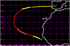
Jeanne remained over the eastern Atlantic. It brushed the Cape Verde Islands, and also caused some gusty winds over the Azores just before losing tropical characteristics. a. Synoptic HistoryJeanne formed from a tropical wave that was slow to emerge
from western Africa. The associated disturbed weather lingered near the
African coast from the 19th through the 20th of September, and gradually
became better organized. An initial Dvorak classification was made by
the Tropical Prediction Center's Tropical Analysis and Forecast Branch
(TAFB) at 1800 UTC 19 September, locating a center about 120 nautical
miles offshore of the coast of Guinea. Only a slight increase in organization
and little motion was noted during the following 24 hours. By 0600 UTC
21 September, deep convection had increased and it is estimated that the
system had become a tropical depression, while centered about 140 nautical
miles southwest of the coast of Guinea-Bissau. The cyclone moved generally west-northwestward, gradually
strengthening into a tropical storm later on the 21st. Jeanne was situated
in an environment of slight east to southeasterly shear, which is typical
for systems in the eastern tropical Atlantic. Early on the 22nd, Jeanne
began to intensify at a faster pace, and by 1800 UTC that day is estimated
to have become a hurricane while centered about 120 nautical miles southwest
of the Cape Verde Islands. This was the closest point of approach to those
islands. For the next couple of days, Jeanne continued moving toward the
west-northwest, strengthening to its estimated peak intensity of 104 mph
while located about 580 nautical miles west of the westernmost Cape Verde
Islands. The forward speed slowed, from 15-20 mph the previous couple
of days, to near 12 mph, and the hurricane turned toward the northwest,
and then north, on 25-27 September. Jeanne weakened, mainly due to increased
southwesterly vertical shear, on 25-26 September. These events were likely
caused by an amplifying mid- to upper-tropospheric trough located about
10 degrees of longitude to the west, a feature which assured that Jeanne
would remain in the eastern Atlantic for its life cycle. Under the continued influence of the trough, Jeanne accelerated
toward the north-northeast on 28 September. The hurricane re-intensified
somewhat, to near 92 mph, while located about 550 nautical miles west-southwest
of the Azores. As the system turned toward the northeast and east-northeast
on the 29th, its forward speed slowed and it weakened to a tropical storm.
Jeanne continued toward the east-northeast while gradually weakening.
Around 0000 UTC 1 October, the cyclone reached the Azores, but had degenerated
to a depression that was losing tropical characteristics. After leaving
the Azores, the extratropical low moved eastward, generating an area of
gale force winds until reaching the coast of Portugal just north of Lisbon
around 0000 UTC 4 October. Jeanne's extratropical remnants became unidentifiable
over Spain later that day. b. Meteorological StatisticsJeanne's peak intensity of 104 mph on 24 September is based
on subjectively-derived Dvorak T-numbers of 5.0 from the TAFB and the
SAB. A French drifting buoy, identifier 41599, reported winds of 060°/63
mph, 060°/55 mph, 110°/86 miles near 23.3N 40.6W at 1000, 1100,
and 1900 UTC, respectively, on 26 September. Although this buoy's data
are considered questionable, the 86 mph wind was used for the best track
intensity, since it was reported very near the center of the hurricane
where a burst of deep convection was occurring at the time. A ship, call
sign GQVJ, reported winds of 170°/41 mph at 30.1N
37.9W at 1200 UTC 28 September. Another ship, with call sign C6KV2,
also reported winds of 170°/41 mph, at 32.4N 35.4W at 1800 UTC 28
September. The island of Horta in the Azores reported wind gusts to
39 mph around 1800 UTC 30 September. c. Casualty and Damage StatisticsThere were no known casualties or damages caused by Jeanne.
Maximum
Intensity For Hurricane Jeanne
| ||||||||||||||