|
|
|
|
|||||||||||||||
|---|---|---|---|---|---|---|---|---|---|---|---|---|---|---|---|
|
1998
PRELIMINARY REPORTS |
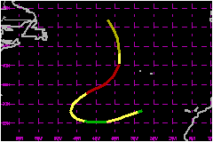
Late season Hurricane Nicole was a tenacious tropical cyclone that persisted for several days over the northeast Atlantic. a. Synoptic HistoryNicole developed from a nearly stationary and strong frontal
low which persisted for several days over the northeast Atlantic, centered
a few hundred miles south of the Canary Islands. Satellite imagery suggested
that the frontal low acquired tropical characteristics when a tightly-wrapped
convective band developed around the center of circulation. It is estimated
that the system reached tropical storm status at 0600 UTC 24 November.
Later on, a ship with call sign PFSJ confirmed that the system
had acquired tropical characteristics when reported 41 mph at 1200 UTC
24 November just to the north of the center of the tropical storm. The
tropical cyclone was then located in the central portion of a larger upper-level
low where the vertical wind shear was relatively weak. This is typical
for these late-season developments in the subtropics. Nicole continued
to become organized while an intermittent eye-feature was observed on
satellite images. Maximum winds increased to 69 mph as indicated by reports
from the same ship. Nicole moved toward the west-southwest for the next few days
while located south of a strong mid-level high pressure ridge. An upper-level
trough moved rapidly eastward over the system, producing a strong wind
shear. The shear removed most of the convection associated with the tropical
cyclone which weakened to tropical depression status on 26 November. If
fact, the system became so weak that advisories were discontinued. However,
the ridge which followed the upper-level trough became superimposed over
the system, decreasing the shear. Deep convection regenerated and unexpectedly,
the system reacquired tropical storm strength by the 27th. Nicole then began to move on a west-northwest track. Thereafter,
it turned toward the northeast ahead of another strong approaching cold
front. Nicole intensified further and reached hurricane status with peak
winds of 86 mph and a minimum pressure of 979 mb at 0000 UTC 1 December.
These estimates were based on satellite images which revealed the formation
of an eye, resulting in objective T-numbers oscillating around 4.5 on
the Dvorak scale. In addition, data from the Defense Military Satellite
Program (DMSP) 85 GHz sensor showed an almost complete eyewall. During
that period, Nicole was moving over a region of anomalously warm sea surface
temperatures of the order of 2 or 3 degrees. This anomalous feature was
probably partially responsible for the intensification of the system.
Nicole moved rapidly northward and north-northwestward around the periphery
of a large deep-layer cyclonic circulation and became extratropical by
1800 UTC 1 December. b. Meteorological StatisticsObservations from the ship PSFJ were crucial to determine
the structure and the intensity of Nicole. In fact, the storm's intensity
was operationally increased to 69 mph based on a 67-mph wind report from
that vessel at 1800 UTC 24 November. c. Casualty and Damage StatisticsThere are no reports of casualty and damage from Nicole.
Maximum
Intensity For Hurricane Nicole
| ||||||||||||||